Friday started off rather chilly across the region, with minimum temperatures in the 30s and 40s. According to LCRA’s Hydromet, low temperatures Friday morning included the mid and upper 30s across the Hill Country, the upper 30s to mid-40s across Central Texas and the mid to upper 40s across the coastal plains. An area of clouds developed across the Hill Country late Thursday night and this layer of clouds kept the temperature from falling below freezing at most locations. However, a couple of spots in the vicinity of Goldthwaite and Brownwood did record lows between 30 and 32 degrees. In Austin, Camp Mabry recorded a low temperature of 44 degrees while Austin-Bergstrom recorded 39 degrees.
Sunny, quiet and cool weather is in place on this Friday. Light northeast to easterly winds at 5-10 mph can be expected this afternoon through tonight. Today’s temperatures is predicted to warm to the mid and upper-60s. It will be clear and cool Friday night. Lows Saturday morning will range from the mid-40s across the Hill Country, to around 50 degrees near the coast.
For the weekend, sunny conditions look to continue Saturday. Temperatures will trend warmer as southerly winds increase to 10-20 mph. Expect readings to generally reach the mid-70s Saturday afternoon. The sky is forecast to become cloudy Saturday night as moisture begins returning off the Gulf. Lows Sunday morning will range from the mid-50s west, to the low 60s near the coast.
Forecasts call for another cold front to sweep southeast across the region Sunday morning through Sunday afternoon. The front is predicted to push across the northern Hill Country late Sunday morning, the Austin area around mid-afternoon and the coastal plains region in the late afternoon and early evening. No rain is forecast with the front when it moves across the Hill Country and the Interstate 35 corridor. However, there will be a slight chance for a few light showers and isolated thunderstorms along the front for areas east of Interstate 35. Rain amounts should only average around a tenth of an inch. Ahead of the front, temperatures are predicted to warm to the upper 70s to low 80s. Behind the front, breezy and cooler conditions will develop.
Lows Monday morning will be near 40-42 degrees across the Hill Country, near 45-48 degrees across Central Texas and near 50-52 degrees across the coastal plains.
Looking at next week, sunny and cooler weather is forecast Monday and Tuesday. High temperatures will be in the mid-60s Monday, warming to around 70-72 degrees Tuesday. It will be chilly Monday night, but no freezes are expected. Lows Tuesday morning will include the mid and upper 30s across the Hill Country, the upper 30s to 40 degrees across Central Texas and the low 40s across the coastal plains. Lows Wednesday morning will be in the 50s.
An unsettled weather pattern is forecast to take shape for the second half of the week, including Thanksgiving Day. Forecasts call for a trough of low pressure to slowly track southeast out of the southern Rockies mid-week, with the trough tracking across Texas Thursday through Friday and exiting to the east sometime next weekend. A cold front associated with the upper trough is predicted to spread south across the area Thanksgiving Day into Thursday night, bringing cooler air.
Based on the factors listed above, clouds are predicted to increase Wednesday, with the sky becoming mostly cloudy Wednesday afternoon. There will be a slight chance for rain showers Wednesday afternoon, followed by an increasing chance for rain showers and isolated thunderstorms Wednesday night through Thanksgiving Day. Periods of rain look to continue across the area Thursday night through Friday as an overrunning pattern sets up. The forecast beyond Friday is somewhat uncertain, as a couple of model solutions show the trough exiting to the east, bringing an end to the rain. Meanwhile, other solutions show the rain lingering into Saturday.
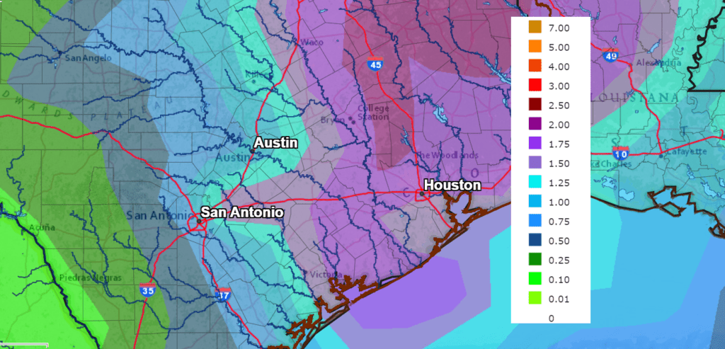
Rainfall forecasts through next Friday call for widespread totals of 1-2 inches for areas east of Interstate 35. To the west of I-35, totals should average between 0.5 and 1 inch.
NWS Rainfall Forecast for the Period 7 pm Friday through 7 pm Next Friday:
Temperatures will trend cooler behind the cold front beginning late Thursday. High temperatures Thanksgiving Day are predicted to be in the upper 60s. High temperatures next Friday through Sunday are forecast be in the low to mid 60s. Meanwhile, low temperatures are predicted to generally be in the upper 40s to 50 degrees.
I’ll have more specifics on next week’s weather in Monday’s report.
Tropical Weather Outlook
Weather conditions are quiet across the tropical Atlantic. Tropical cyclone development is not expected as atmospheric conditions have become unfavorable with the change of season.
Lunar Eclipse Recap
The sky was clear across the eastern half of Texas Thursday night and conditions were perfect for observing the near-total lunar eclipse. If you slept in and missed the event, you can check out some photos of the awesome-looking eclipsed moon from EarthSky’s eclipse photo gallery: https://earthsky.org/todays-image/lunar-eclipse-photos-nov-18-19-2021
Have a good weekend.
Bob
Social Media