A large area of rain showers and thunderstorms developed across West Texas late Thursday night ahead of a Pacific cold front. The showers spread east across the Hill Country and Central Texas regions late Thursday night into Friday morning. Although a few of the storms did produce some strong and gusty winds, severe weather was much more limited, compared to the storms affecting the area last Monday night. According to LCRA’s Hydromet, rain totals from the overnight storms generally ranged between 0.5 and 1 inch, with several gauges recording between 1 and 1.25 inches.
The line of rain and storms is forecast to spread across the middle Texas coast early Friday afternoon, pushing off the coast by 3 pm. Some of these storms will have the potential to become strong or severe and produce locally heavy rain. The threat for severe weather will decrease behind the line of storms mid to late afternoon. Rain amounts resulting from the line of storms is forecast to average around an inch.
While the threat for strong storms and heavy rain has diminished behind the line thunderstorms/cold front, the northern half of the Hill Country and the northern counties of Central Texas may still see some occasional light rain showers through late afternoon as moisture wraps around the parent trough of low pressure located over North Texas. The chance for rain will diminish across the region early Friday evening as the upper trough exits northeast, allowing drier air to spread into Central and South Texas.
For the Hill Country and Central Texas regions, Friday afternoon’s weather will include a mostly cloudy, breezy northwesterly winds, and temperatures in the upper 50s to low 60s. Across the coastal plains, afternoon temperatures will be in the 70s, falling into the 60s. Expect a cloudy sky Friday night. Lows Saturday morning will range from the upper 40s across the Hill Country, to the mid-50s near the coast.
Clouds look to decrease from south to north Saturday morning as the upper trough moves further north into Arkansas. Expect a mostly sunny sky by afternoon, followed by a mostly clear sky Saturday night and Sunday. It will be breezy on Saturday, with northwesterly winds at 10-15 mph and gusts 30 mph. Winds speeds should diminish Saturday night. High temperatures Saturday will generally be in the upper 60s, warming to the mid-70s Sunday. Lows Sunday and Monday mornings are forecast to be in the upper 40s to low 50s.
Looking ahead to next week, Monday’s weather will be mostly sunny and mild with a high temperature in the mid and upper 70s.
->For the ghosts and goblins, Monday evening weather will feature a partly to mostly cloudy sky and dry weather. Temperatures will be in the low 70s around 6 pm, with readings falling through the 60s Monday evening.
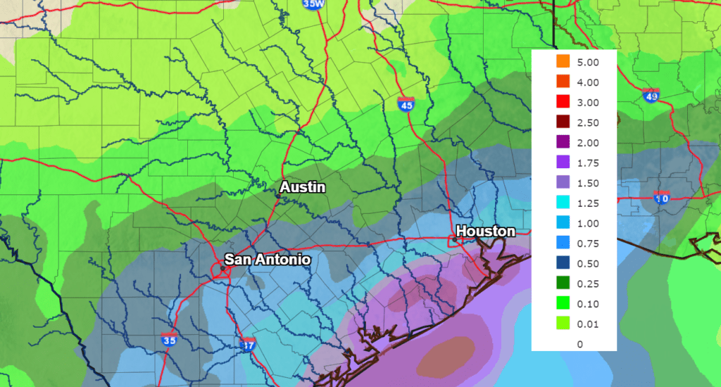
On Tuesday, a chance for rain showers and isolated thunderstorms will enter the forecast when a small trough of low pressure tracks northeast out of northern Mexico. Moisture returning off the Gulf will help produce scattered rain showers and thunderstorms across the region Tuesday into Tuesday night. The probability for rain will range from 30 percent across the northern Hill Country, to 60 percent near the coast. Rain amounts will be heaviest near the coast, where totals are predicted to be in the range of 1-2 inches. Amounts will be the lowest towards the north, where totals are forecast to average less than an a quarter inch. The chance for rain is forecast to diminish late Tuesday night. High temperatures Tuesday are forecast to be in the mid-70s.
NWS Rainfall Forecast for the Period 7 pm Monday through 7 pm Wednesday:
Mostly sunny, dry, and mild weather is forecast next Wednesday through Friday. Daily high temperatures are predicted to be in the low 80s, with low temperatures in the low and mid-70s.
The outlook for next weekend will feature another chance for rain. Forecast solutions call for a trough of low pressure to track northeast across West Texas out of northern Mexico, pulling moisture back into the state and causing a chance for showers Saturday and Sunday. High temperatures will be in the upper 70s to low 80s.
Looking out into the first full week of November, temperatures are predicted to remain mild, with highs in the 70s, and lows in the 50s.
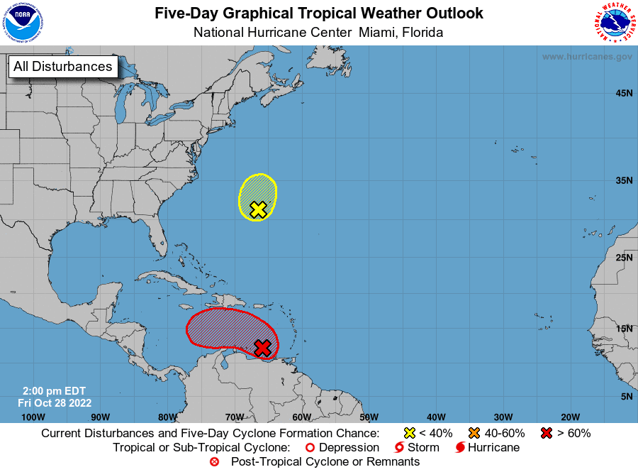
Tropical Weather Outlook
National Hurricane Center forecasters are monitoring two areas for possible development.
In the southeastern Caribbean Sea, a broad area of low pressure is producing a large area of disorganized showers and thunderstorms extending from the Windward Islands west-northwestward for several hundred miles. Environmental conditions are forecast to be conducive for gradual development over the next few days, and a tropical depression is likely to form this weekend or early next week while the disturbance moves slowly westward or west-northwestward over the central Caribbean Sea. Regardless of development, locally heavy rainfall is possible over portions of the Lesser Antilles, the Virgin Islands, and Puerto Rico through this weekend. NHC forecasters are giving this system a 70 percent chance for development over the next 5 days.
In the western Atlantic, satellite data indicated a well-defined low pressure area has formed about 150 miles southwest of Bermuda. This system is currently producing a limited amount of shower and thunderstorm activity. Environmental conditions are forecast to remain only marginally conducive, and any additional development should be slow to occur over the next day or so. By late Saturday, upper-level winds are forecast to become even less favorable, and the low is expected to begin interacting with an approaching frontal system. Therefore, development after that time is not anticipated. NHC forecasters are giving this system just a 20 percent chance for development over the next 5 days.
Have a good weekend!
Bob
Social Media