Widespread rain and thunderstorms moved across the region Monday. The heaviest rain and highest totals occurred across the Austin/Travis County area, as well as Mason County. Both spots saw peak totals between 4 and 5 inches. Overall, Hill Country totals ranged from around a third of an inch on the eastern side, to near 2 inches on the western side. Across Central Texas, most totals ranged from a half inch up to 3 inches. Totals were the lowest across the coastal plains, where most totals were less than a quarter inch.
There was a very interesting aspect to Monday’s rain in Austin. The climate site at Camp Mabry recorded 2.96 inches of rain between 4 pm and 5 pm. According to Austin’s climate database, this was the highest one hour total ever recorded at this site, dating back to 1948. That 2.96 inch total is more than the average total for the entire month of August (2.74 inches). And the 3.73 total for the entire day was more than double the amount of rain recorded so far this summer.
The wet and unsettled pattern remains in place today. The weak cold front which sank south into the area Monday has pulled up stationary along a line from around Del Rio, to near Austin, to just east of Dallas. Today’s atmosphere is also unusually moist. But the forcing to generate showers and thunderstorms does not appear to be as great as it was on Monday. High-resolution forecasts call for scattered showers and thunderstorms to develop across the region this afternoon, with the greatest coverage expected to be to the east of Interstate 35. Moderate to occasionally heavy rain will be possible. The probability for rain will generally be around 50 percent, decreasing to 30 percent this evening. Rain amounts are forecast to average less than a half inch across the Hill Country, and be between 0.5 and 1 inch for areas east of I-35.
While locally heavy rain will still be possible at some locations, the rain is not expected to be as widespread as we saw on Monday. As a result, the National Weather Service has canceled the Flash Flood Watch which had been posted for the eastern Hill Country and the Interstate 35 corridor.
The outlook for Wednesday and Thursday calls for a similar pattern across the area with the stalled boundary and a very moist atmosphere. But again, no strong forcing for thunderstorm development is predicted. The most favorable area for rain is expected to be for areas to the east of Interstate 35. Expect a partly cloudy sky with a 40 percent chance for scattered, mainly afternoon and evening showers and thunderstorms across the region. 2-day totals are forecast to average around a half inch for areas east of I-35, and average around a quarter inch for locations to the west of I-35.
Friday and through the weekend, there will be just a slight chance for scattered rain showers and thunderstorms across the Hill Country and Central Texas regions as the atmosphere becomes more stable. Meanwhile, there will be a 50 percent chance for more scattered afternoon showers across the coastal plains.
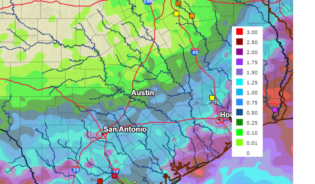
Rain amounts through Sunday are forecast to be heaviest for areas east of I-35. Here, the National Weather Service is forecasting totals of around 1-2 inches. For areas west of I-35, totals are forecast to range from less than a quarter inch north, to near 1 inch to the south.
NWS Rainfall Forecast for the Period 7 pm Tuesday through 7 pm Sunday:
The outlook for next week calls for at least a slight chance for rain in the forecast each day.
Bob
Social Media