It’s been quite a week for heat, with readings topping out in triple-digits across the Hill Country and into the mid and upper 90s at most other locations. Average temperatures for the month are generally running between 6 and 10 degrees above normal. Unfortunately, more August-like temperatures can be expected this afternoon and Saturday, but cooler air will begin to arrive Sunday, providing a nice break from current heat wave.
A mostly sunny to partly cloudy sky will be in place across the region this afternoon. It is shaping up to be another very hot day, with high temperatures ranging from about 100 degrees across the Hill Country, to the low and mid-90s across the coastal plains region. In addition to the hot temperatures, today’s weather will also feature a slight chance for some scattered thunderstorms across the Hill Country and Central Texas regions. Forecasts call for a small trough of low pressure to track from northeastern Mexico across the Hill Country and Central Texas regions late this afternoon and evening. Although atmospheric parameters are only somewhat favorable for thunderstorm development, high-resolution forecasts do call for the development of a few storms across the region. Any storms that do happen to develop could strengthen close to severe levels, with large hail being the primary severe weather threat. For locations that do happen to see rain, totals are forecast to remain under a half inch. The chance for scattered thunderstorms should diminish by late evening.
More mostly sunny and hot weather is forecast across the region Saturday. Expect high temperatures in the upper 90s across the Hill Country and Central Texas regions, and into the middle 90s across the coastal plains. Similar to Friday afternoon, there will be another slight chance for a few scattered thunderstorms across the Hill Country and the Interstate 35 corridor Saturday afternoon into Saturday evening as the dry line pushes east out of West Texas. Meanwhile, forecasters will also be keeping a close watch on a cold front that will be slowly sagging south out of North Texas. The cold front is predicted to spread across the northern Hill Country late Saturday afternoon and the Austin/Central Texas area Saturday evening through Saturday night. Atmospheric conditions appear favorable an area of rain showers and thunderstorms to develop along and behind the cold front. Some of the storms could be strong to severe—producing large hail and damaging winds. The probability for rain will be near 40-50 percent. Rain amounts across the Hill Country and Central Texas region through sunrise Sunday are forecast to average close to a half inch. Cooler air will spread in behind the cold front. Lows Sunday morning will include the low 60s across the Hill Country, with mid and upper 60s across Central Texas.
The cold front is forecast to sag south through the coastal plains region Sunday morning, pulling up stationary somewhere close to the U.S. Highway 59 corridor. Forecasts call for a 50 percent chance for showers and thunderstorms across the coastal plains region Sunday and Sunday night. Rain amounts through sunrise Monday are forecast to average between 0.5 and 0.75 inches. For the Hill Country and Central Texas regions, expect a partly to mostly cloudy sky on Sunday. There will be 30 percent chance for a few passing showers and isolated thunderstorms. Rain amounts through sunrise Monday are forecast to average around a quarter inch, or less.
High temperatures Sunday will include the upper 70s across the Hill Country, near 80 degrees across Central Texas, and in the mid to upper 80s across the coastal region.
An unsettled weather pattern is forecast to remain with us Monday through Wednesday as a series of low pressure troughs move over our region and the front remains stalled close to the coast. Periods of widespread rain and thunderstorms are forecast Monday through Wednesday, with the highest chance for rain expected to occur Monday night and Tuesday when a strong trough moves over the area. There is still a lot of uncertainty about the specific evolution of this system, but confidence for increased rain chances is high. Forecasts call for widespread totals of 1-1.5 inches across the Hill Country and Central Texas regions Monday night through Tuesday evening. Totals of 0.5-1 inch are forecast across the coastal plains. Additional periods of rain and thunderstorms are forecast across the entire region Tuesday night through Wednesday night. The chance for rain is expected to diminish late Wednesday night when a ridge of high pressure begins to spread over the area out of Mexico.
High temperatures Monday through Wednesday are forecast to mostly be in the mid-80s.
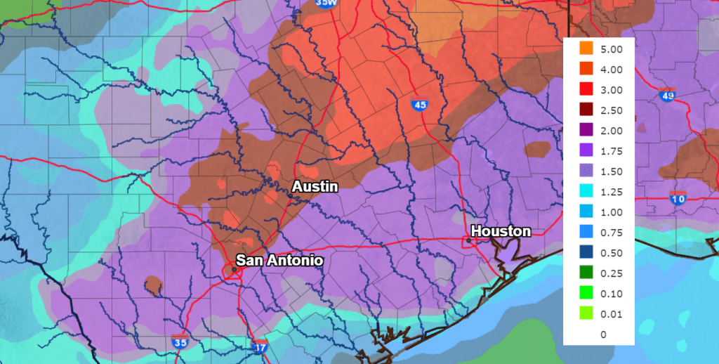
Generally speaking, forecasts call for widespread totals of 1-3 inches of rain to occur over the next 5 day period, with the highest totals expected to occur across the eastern Hill Country and the Interstate 35 corridor. Isolated totals of 3-5 inches will be possible.
NWS Rainfall Forecast for the Period 7 am Friday through 7 am Next Friday:
Mostly sunny, dry and warm weather is forecast to resume next Thursday as the ridge strengthens across Texas. This dry and warm pattern is forecast to continue through the Memorial Day weekend, including Memorial Day. Expect afternoon high temperatures to generally be in the low 90s.
Tropical Weather Outlook
Weather conditions are quiet across the tropical Atlantic and tropical cyclone development is not expected over the next 5 days.
Have a great weekend!
Bob
Social Media