All eyes are currently on a large trough of low pressure across the western U.S. that stretches from central Montana to southern Nevada. The trough is forecast to track to the east tonight and Friday, then lift northeast to the Middle Mississippi Valley on Saturday. The trough will help push a Pacific cold front across Texas Friday into Friday, with strong to severe thunderstorms expected to develop along the cold front by the time it reaches the eastern Hill Country and the Interstate 35 corridor. A threat for severe storms will continue along the cold front as it pushes southeast to the coast Friday night. Forecasts put the cold front into the western Hill Country around noon Friday, across the Austin/Interstate 35 corridor between 6 and 8 pm Friday evening, and the coastal plains region around 11pm-midnight.
The latest high-resolution forecast data indicates there will be a potential for the development of isolated severe thunderstorms across the eastern Hill Country and much of Central Texas Friday afternoon in advance of the approaching cold front. Showers and thunderstorms are predicted to develop and increase in areal coverage along the cold front around mid-afternoon, roughly when the cold front reaches close to Highway 83 across the Hill Country. The rain and thunderstorms are then predicted to transition into a large, discrete line that will parallel the cold front as it pushes to the southeast. The chance for rain is predicted to end across the Hill Country by early Friday evening. The rain and storms are predicted to move out of Central Texas by late evening, and the coastal counties shortly after midnight.
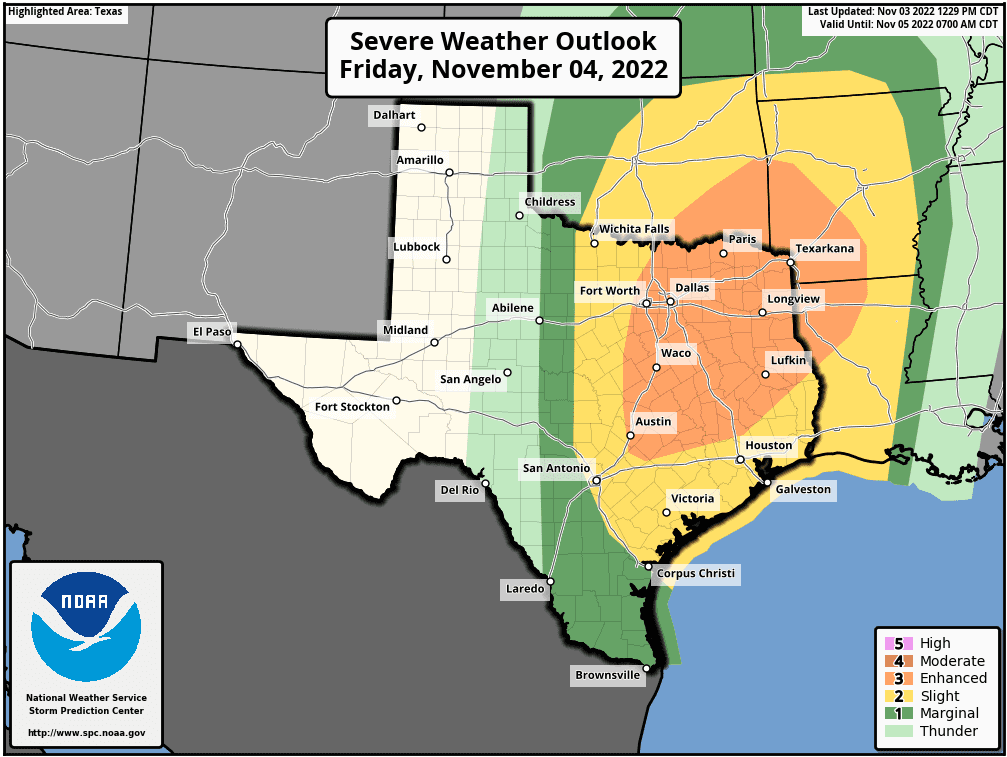
The primary severe weather threat from the storms on Friday is expected to be damaging straight-line winds. However, the atmospheric setup will also somewhat favorable for the development of isolated tornadoes and large hail. As of now, it appears the Austin/Interstate 35 corridor will see the greatest risk for tornadoes. The Storm Prediction Center has placed the area along and east of line stretching from Gatesville, to Austin, to La Grange, and Brenham in an Enhanced Risk (a 3 out of 5 risk) for severe thunderstorms Friday. The eastern Hill Country and the coastal plains region are under a Slight Risk (a 2 out of 5 risk) for severe thunderstorms through Friday night.
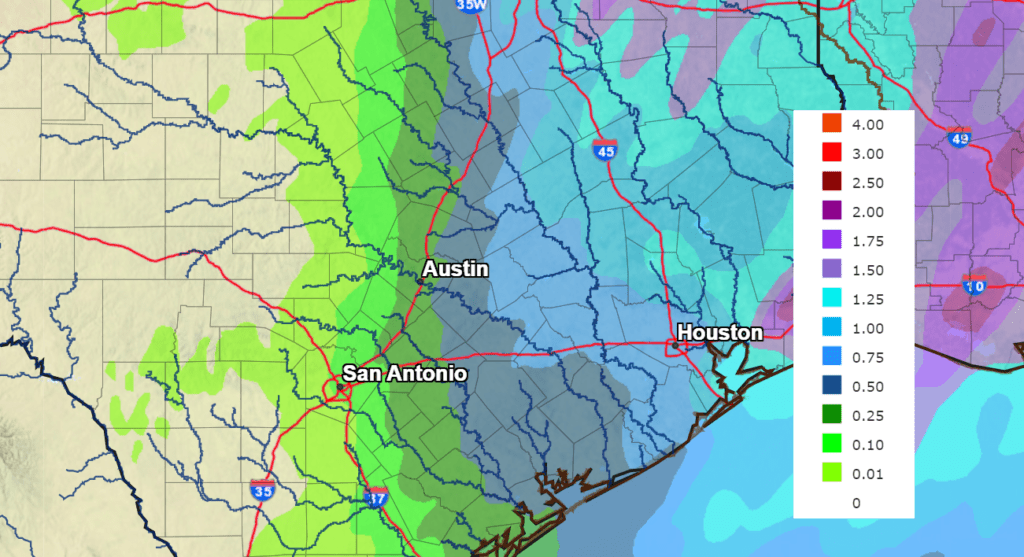
Generally speaking, the threat for significant rain across the Hill Country and Central Texas regions Friday through Friday night appears minimal. Here totals are predicted to be around a quarter to a half inch, or less. Heavier rain is forecast for locations east and southeast of Austin, where the areal coverage of storms along the cold front is expected to expand. Totals of 0.50-0.75 inches are forecast.
NWS Rainfall Forecast for the Period 7 pm Thursday through 7 pm Saturday:
I’ll pass along another update on the weather Friday morning.
Bob
Social Media