It’s the start of a new week, but it’s the same ol’ hot and dry forecast. As we move through this last week of July, very few changes in the weather pattern can be expected. It’s shaping up to be another week of triple-digit heat along with no rain.
Texas continues to be at the mercy of a broad ridge of high pressure, or heat dome, now covering most of the western, central and southeastern U.S. Forecasts call for the ridge to remain over the southern U.S. throughout the week, continuing into next week. There are some indications the ridge will weaken slightly late week and through the upcoming weekend, which might help lower temperatures a couple of degrees. Aside from that, expect more sunny, dry, and hot weather throughout the week and the upcoming weekend.
Forecasts call for a small, weak trough of low pressure over the western Gulf of Mexico to push inland along the middle and upper Texas coast late Wednesday. This system may cause a few isolated showers along the middle Texas coast Wednesday afternoon and Wednesday evening. However, the chance for rain will only be 20 percent and most totals should average less than a tenth of an inch.
- High temperatures Monday and Tuesday are forecast to be near 101-104 degrees across the Hill Country and Central Texas regions, and in the upper 90s across the coastal plains.
- High temperatures Wednesday through Sunday are forecast to be near 99-103 degrees across the Hill Country and Central Texas regions, and in the mid to upper 90s across the coastal plains.
Forecasts late last week were pointing toward a slight chance for rain this Friday and Saturday when a weak cold front was predicted to sag south to the Red River. The most recent data now calls for the front to stall over Oklahoma, and the atmosphere across the Hill Country and Central Texas to be too stable for the development of any showers or thunderstorms.
I know we’re all wanting to see a break from heat. Unfortunately, long-range forecasts for next week are showing little to no change. A broad ridge of high pressure is forecast to remain across Texas and the southern U.S. throughout the week, causing more sunny, hot, and dry weather.
- High temperatures next week are forecast to be near 101-104 degrees across the Hill Country and Central Texas regions, and in the upper 90s across the coastal plains.
The tropics are forecast to remain quiet through the middle of next week.
Tropical Weather Outlook
Weather conditions are quiet across the tropical Atlantic. There are no systems in place posing a threat for tropical development through late week.
A Brilliant Fireball Seen Across Central Texas Sunday Night
The American Meteor Society (AMS) received over 200 reports and several videos displaying a fireball event at 10:52 pm CDT Sunday evening. The AMS #2022-4290 event was mainly seen across Texas, but reports were also received from Oklahoma and Louisiana. The initial computer-generated trajectory shows the fireball entered the atmosphere over Cistern, Texas (Fayette Country), and its flight ended just a few miles west of Austin. Several witnesses near the flight path reported hearing a delayed sonic boom, indicating that meteorites from this fireball might have survived the fiery passage through Earth’s atmosphere, and are now on the ground.
This particular fireball or meteor was probably the size of a small car prior to entering the atmosphere. But any meteorites found will probably be just small fragments of the original fireball.
You can see 3 videos of the fireball captured by doorbell video cameras on the AMS’s website: Fireball event (amsmeteors.org)
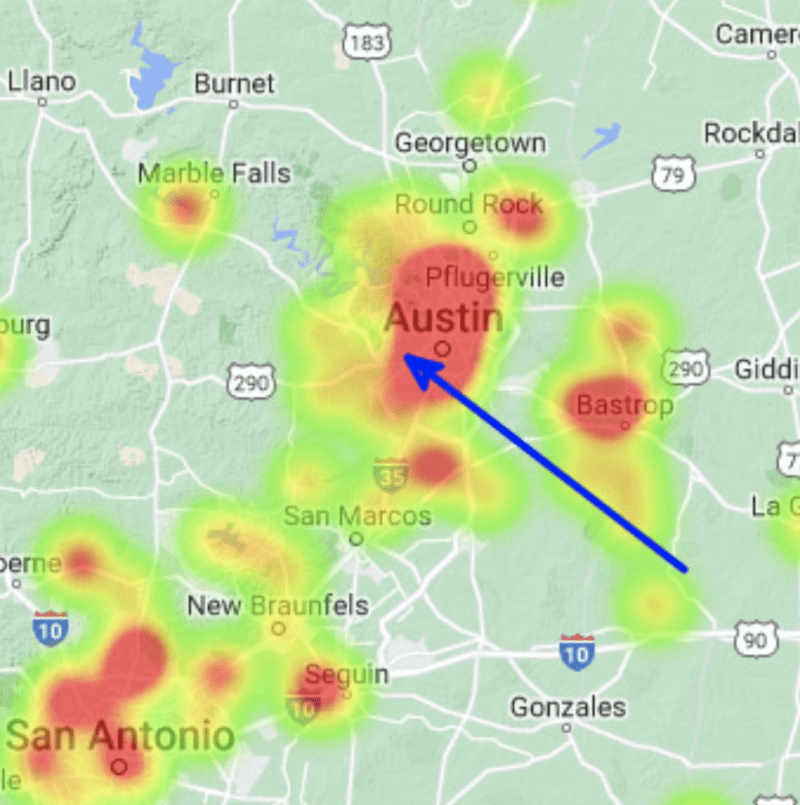
The fireball entered the atmosphere over Cistern, Texas, and its flight ended just a few miles west of Austin. Image via AMS.
Bob
Social Media