Although autumn will officially begin next Thursday, temperatures over the next week or so are going to be more typical of those we experience in June and July, rather than the start of autumn. The culprit will be an unusually strong ridge of high pressure, or heat dome, that will be spreading over the central and southern Plains states beginning early next week. Dry weather will accompany this upcoming heat spell as the atmosphere dries out and becomes quite stable.
Ahead of next week’s hot and dry weather, there will be a 40-50 percent chance for scattered rain showers and isolated thunderstorms this afternoon and Saturday afternoon across the coastal plains region as an area of enhanced moisture spreads inland from the western Gulf of Mexico. A chance for spotty showers is forecast to extend inland to around Seguin, Bastrop, and Navasota. Rain amounts both days are forecast to average close to a half inch across the coastal plains region, and total less than a quarter inch for locations further inland. Unfortunately, the moisture is not expected to push inland beyond the Interstate 35 corridor, so weather conditions are expected to stay dry across the Hill Country both days. Expect a mostly sunny to partly cloudy sky, with high temperatures in the low to mid-90s. Low temperatures will be in the low 70s with wind speeds in the range of 5-10 mph.
Forecasts call for a ridge of high pressure in the middle and upper atmosphere to begin setting up across Texas on Sunday. There will be just a slight chance for a few scattered rain showers across the coastal plains region, with sunny and dry weather expected across the Hill Country and Central Texas regions. Expect a mostly sunny sky with high temperatures in the low and mid-90s.
The ridge is predicted to expand its areal coverage to include the southern and central U.S. next Monday through Saturday. At the same time, the ridge is forecast strengthen to a level we typically see in June and July. So it should be no surprise that high temperatures next week are forecast to reach close to mid-summer levels. Sunny and dry weather will be in place throughout the week.
- High temperatures Monday are forecast to generally be in the mid-90s. A few spots across Central Texas could see mid to upper 90s.
- High temperatures Tuesday through Saturday are forecast to be in the upper 90s across Central Texas, in the mid to upper 90s across the Hill Country, and in the low to mid-90s across the coastal plains.
The ridge over Texas is forecast to weaken next Sunday. Also next Sunday, the ridge is forecast to begin shifting west to the western U.S. This should translate to less hot temperatures for the week of September 26, with high temperatures returning to the low and mid-90s. Little to no rain is showing up in the forecast for the last week of September.
Tropical Weather Outlook
As of early Friday afternoon, tropical storm Fiona was centered about 75 miles east of Guadalupe, in the Leeward Island. Top winds were near 50 mph, with higher gusts. Gradual strengthening is forecast during the next few days. A westward motion with a decrease in forward speed is expected through early Sunday, followed by a turn toward the west-northwest and northwest Sunday and Sunday night. On the forecast track, the center of Fiona is expected to move across the Leeward Islands tonight, near or just south of the Virgin Islands and Puerto Rico Saturday into Sunday, and approach the southern coast of the Dominican Republic Sunday night and early Monday.
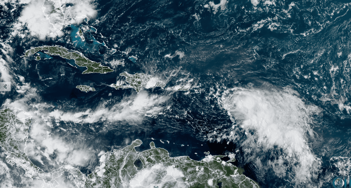
NOAA/Colorado State University/RAMMB 09/16/2022 1:50 pm CDT
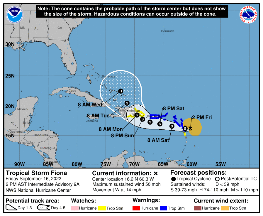
Long-range forecasts continue to call for Fiona’s track to bend to the northwest and north early next week—staying to east of the Gulf of Mexico. A path toward the Gulf of Mexico now appears unlikely. There is still much uncertainty as to whether Fiona will move close to the East Coast, or bend east into the open Atlantic next week.
The National Hurricane is monitoring a strong tropical wave that is located over the central tropical Atlantic and moving to the north. A second tropical wave is located over the western Atlantic, a few hundred miles west-northwest of Bermuda. Neither system is showing much potential for tropical development and neither pose a threat to the Gulf of Mexico.
Enjoy this last official weekend of summer!
Bob
Social Media