Welcome to the first day of astronomical summer! Summer is the longest season of the year, lasting 94 days (winter is the shortest season of the year, lasting 89 days). While astronomical summer is just getting started, summer-like temperatures arrived across Central Texas in early May this year, and they are showing no signs of backing down anytime soon. The average temperature so far through June is running between 4 and 5 degrees above normal, with the average now ranking among the hottest Junes of record—and hotter than June 2011.
Much of Texas continues to be under the influence of a powerful ridge of high pressure in the upper atmosphere that stretches from northern Mexico to the Great Lakes. The ridge is currently centered over the middle Mississippi Valley. The ridge is causing dry and very hot conditions from Texas, all the way north to the Canadian border. Forecasts call for the ridge to expand more to the west this week, while becoming more east-west oriented by late week. The center of the ridge is forecast to spread southwest to a position over Oklahoma, northern Texas, and Arkansas by the weekend. With the ridge center coming closer to our region, temperatures are forecast to rise a couple of degrees further Friday through the weekend.
In broad terms, no significant change in the weather can be expected this afternoon through Sunday. The summer doldrums will be in place, with continued sunny and dry weather. Temperatures will remain unseasonably hot, with readings each day reaching the triple digits. With a moderate pressure gradient in place this week, wind speeds are forecast to remain mostly in the range of 10-15 mph.
- This afternoon through Thursday, expect high temperatures to be near 100-103 degrees across the Hill Country and Central Texas regions, and be
- Friday through Sunday, expect high temperatures to be in the range of 101-105 degrees across the Hill Country and Central Texas regions, with highs of 100-102 degrees across the coastal plains.
Some minor changes in the weather pattern are forecast to take place early next week when the center of the ridge shifts to the central Rockies and a trough dips south across the northern Plains states. A cold front associated with the trough is forecast to sink south into North Texas late Sunday and there are indications the front may slide south through Central Texas on Tuesday before pulling up stationary. Forecasts indicate a few widely scattered rain showers may develop along the cold front. However, these showers will be struggling to develop in a fairly dry and stable atmosphere. So the probability for rain will at best be 20 percent, and rain amounts, if any, should only total around a tenth of an inch. The front is not expected to have any significant impact on the temperature.
- High temperatures next Monday and Tuesday are predicted to be in the upper 90s across the northern Hill Country and be close to 100 degrees across Central Texas and the middle Texas coast.
More dry and very hot weather is forecast for the middle and latter parts of next week as the center of the ridge shifts east to the southern Rockies.
- High temperatures next Wednesday through Friday are forecast to generally be near 100-103 degrees across the entire region.
Long-range forecasts looking out into early July are unfortunately showing little change as large ridge of high pressure remains over our region.
Tropical Weather Outlook
Weather condition across the tropical Atlantic, Caribbean Sea, and the Gulf of Mexico are currently very quiet. There are no systems in place which pose a threat for tropical development over the next 5 days.
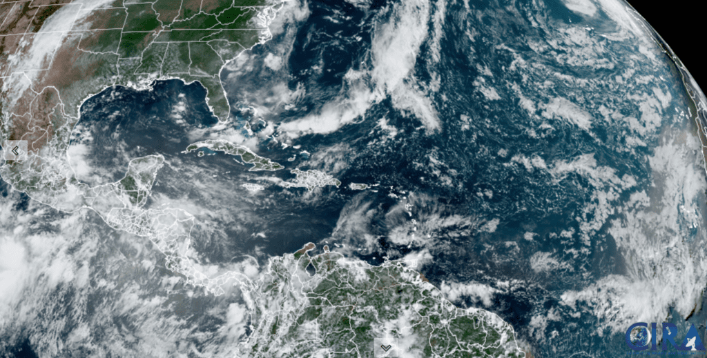
NOAA/Colorado State University/RAMMB 06/21/22 1:50 pm CDT
Interesting Note on the Summer Solstice
While the summer solstice marks the height point of the sun in our sky and the longest days, the hottest temperatures of summer typically don’t occur until a month or two later (if that’s even possible this year J). That’s because the land, oceans, and the atmosphere need those extra weeks to warm up, before the truly hot summer heat can begin. This phenomenon is called the lag of the seasons. In Austin and Central Texas, the hottest temperatures of summer typically occur in the first two weeks of August. Stay tuned; summer’s heat may get even worse.
Bob
Social Media