Data through the first half of June indicates the temperature across Central Texas and the Hill Country averaged among the hottest ever observed for June. Although parts of the area saw some rain showers on June 4th, the remainder of the month has been rain-free. So far this month, the weather has resembled what our region typically sees in the month August; much more than a typical June.
Unfortunately, the current hot and dry weather pattern is showing no signs of moderating or breaking down anytime soon. Friday morning’s weather maps showed a broad heat dome, or ridge of high pressure, covering all of the central and southern U.S., along with northern Mexico. The ridge was centered over Oklahoma and Kansas. Weather conditions underneath the ridge are quite stable and hot as most all of the active weather is currently tracking around the periphery of the high pressure ridge—well away from Texas. Forecasts call for the center of the ridge to drift east to the middle Mississippi Valley region early next week, then move back to the southern Plains states late next week into next weekend. This slight change in the position of the ridge is expected to have little to no impact on the very hot temperatures and dry weather across Texas over the next ten days.
In the near-term, the coastal plains region and the eastern counties of Central Texas could see a few isolated rain showers and thunderstorms this afternoon as a weak wave of low pressure tracks west into Southeast Texas, around the periphery of the upper ridge. This low will be fighting the stable influence of the large ridge, so only isolated activity is forecast. The probability for measurable rain will be at 20-30 percent, and rain amounts are forecast to only total around a tenth of an inch. The chance for rain is expected to diminish around sunset. Across the Hill Country and most of Central Texas, including the Austin area, no rain is forecast as the atmosphere will be too stable. Expect more sunny and very hot weather. Friday’s temperature is forecast to peak around 100-102 degrees across the Hill Country and Central Texas regions, and in the mid-90s across the coastal plains. Friday’s wind speeds are predicted to be in the range of 5-10 mph.
For the holiday weekend, continuing through the middle of next week, the weather looks to stay sunny, dry, and unseasonably hot. Expect little day-to-day change in the weather. Wind speeds are forecast to be in the range of 5-12 mph.
- High temperatures Saturday through Thursday are forecast to be near 100-103 degrees across the Hill Country and Central Texas regions, and be around 97-100 degrees across the coastal plains.
Late next week and next weekend, sunny weather and slightly hotter temperatures are forecast as center of the ridge moves closer to our area.
- High temperatures next Friday through Sunday are forecast to be near 103-106 degrees across the Hill Country and Central Texas regions, and be around 100-102 degrees across the coastal plains.
Looking out into the week of June 27th, no real change in the weather is expected as the ridge of high pressure continues over our area. Forecasts do call for the center of the ridge to slowly shift west to New Mexico and Arizona this week, which should bring our high temperature down 2-3 degrees.
Tropical Weather Update
National Hurricane Center forecasters are monitoring and area of showers and thunderstorms over the northwestern Caribbean Sea. This area of disorganized showers is associated with a trough of low pressure. Some slow development of this system is possible before the system moves inland over northern Central America and the Yucatan Peninsula Friday night or on Saturday. Regardless of development, locally heavy rainfall will be possible over Honduras, Belize, northern Guatemala, and southeastern Mexico through the weekend.
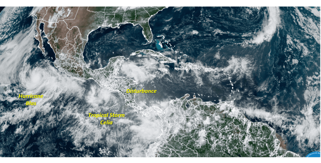
Elsewhere, conditions are quiet and tropical cyclone formation is not expected over the next five days.
Saharan Dust Update
The heavy plume of Saharan dust which moved inland off the Gulf Wednesday and Thursday is now spreading up to our north. According to the TCEQ, the density of the dust should decrease across the area today. The majority of the dust is forecast to exit our region over the weekend.
Another pulse of Saharan dust is forecast to spread into the state next Tuesday into Wednesday, but the density of this next batch of dust is not expected to be quite as heavy as we saw over the past couple of days.
Summer Solstice Happens Tuesday
The solstice will arrive Tuesday at 4:13 am CDT. The solstice is when the Sun is farthest north for the year (in Earth’s sky), and begins its six-month return southward. At this point, summer begins in the Northern Hemisphere while winter starts in the Southern Hemisphere. For people in the Northern Hemisphere, this will be the day with the most daylight of the entire year. In Austin, this day is 3 hours, 54 minutes longer than the December solstice.
The solstice is also the day when the midday Sun will pass closest it ever can to being straight overhead, and thus when your shadow becomes the shortest it can ever be. In Austin, the sun will reach a midday altitude of 83 degrees above the horizon—just 7 degrees from being directly overhead.
And if you have a good west-northwest horizon, mark carefully where the Sun sets Tuesday. In a few days you should be able to detect that the Sun is again starting to set just a little south, or to the left of that point.
Have a good weekend. Stay cool and stay hydrated. Continue to take extra precautions for the hot weather this weekend if you plan to spend any time outdoors or at the beach.
Bob
Social Media