The Weather Pattern Looks to Stay Generally Dry and Warm all Week
May 22, 2023
Monday started off somewhat cool, with temperatures in the upper 50s to low 60s across the Hill Country, and in the low to mid-60s across Central Texas. Unfortunately, this will likely be the coolest mornings our region will see until the fall. Temperatures will be trending warmer as we move through the week and the start of June, with no additional cold fronts on the horizon.
Following several weeks of wet and sometimes stormy weather, a fairly benign weather pattern is beginning to take shape across Central and South Texas. A strengthening ridge of high pressure in the middle and upper atmosphere to our west is expected to keep the weather generally dry through early next week. A couple of waves of low pressure tracking south across West Texas Tuesday and Wednesday may help to spark some scattered thunderstorms across parts of the Hill Country and the Interstate 35 corridor, but no widespread or heavy rain is expected. Memorial Day weekend weather is looing generally dry and warm.
The temperature will be trending warmer this week, with high temperatures predicted to be around 90-92 degrees this weekend and early next week.
Here is the breakdown on this week’s weather:
This Afternoon through Tonight
A mostly sunny sky is forecast this afternoon. The temperature is predicted to warm to the mid-80s across the entire region. Lows Tuesday morning will be mostly in the mid-60s. Expect a light east and northeasterly wind.
Tuesday through Wednesday
There will be a slight chance for scattered late day and evening thunderstorms across the Hill Country and Interstate 35 corridor both days. Forecasts call for a couple of waves of low pressure to track southeast out of the Panhandle Tuesday through Wednesday. These waves of low pressure are forecast to cause the development of scattered afternoon thunderstorms along the dry line across West Texas and the Rio Grande Plains. These storms are then forecast to track east across the Hill Country, possibly reaching as far east as the Interstate 35 corridor Tuesday evening and Wednesday evening. Some of these storms may be strong to severe. The primary severe weather threats will be damaging winds and large hail. The probability for rain will be 20 percent Tuesday and around 30-40 percent Wednesday. For locations that do happen to see rain and storms, rain amounts are forecast to average less than a half inch.
Expect a partly cloudy to mostly sunny sky both days, with high temperatures generally in the upper 80s. Lows Wednesday and Thursday mornings will be in the upper 60s.
Thursday through Memorial Day
Mostly sunny and generally dry weather is forecast through the holiday weekend as the ridge to our west spreads over Texas and the southern Plains states. A couple of isolated late afternoon and evening thunderstorms will be possible across the Edwards Plateau, but most areas should be dry.
High temperatures Thursday and Friday are forecast to be near 88-90 degrees. Lows will be in the upper 60s.
High temperatures Saturday through Monday are forecast to be near 90-92 degrees, with lows in the upper 60s.
Next Week
Long-range forecasts call for a slight chance for rain and thunderstorms each day next week as the ridge over Texas weakens, and small waves of low move across Texas out of northern Mexico. No widespread or heavy rain is forecast.
High temperatures next week are forecast to be in the low 90s.
Tropical Weather Update
Although the Atlantic hurricane season doesn’t officially start until June 1st, NHC forecasters are monitoring an area of disturbed weather located across the southwestern Atlantic. Satellite images show an area of disorganized showers and a few thunderstorms associated with a broad area of low pressure located a couple of hundred miles northeast of the central Bahamas. This area of thunderstorms developed Sunday, but they are now decreasing in organization. Environmental conditions Monday have become more hostile and development of this system is not expected as the system moves off to the north-northeast at 5 to 10 mph.
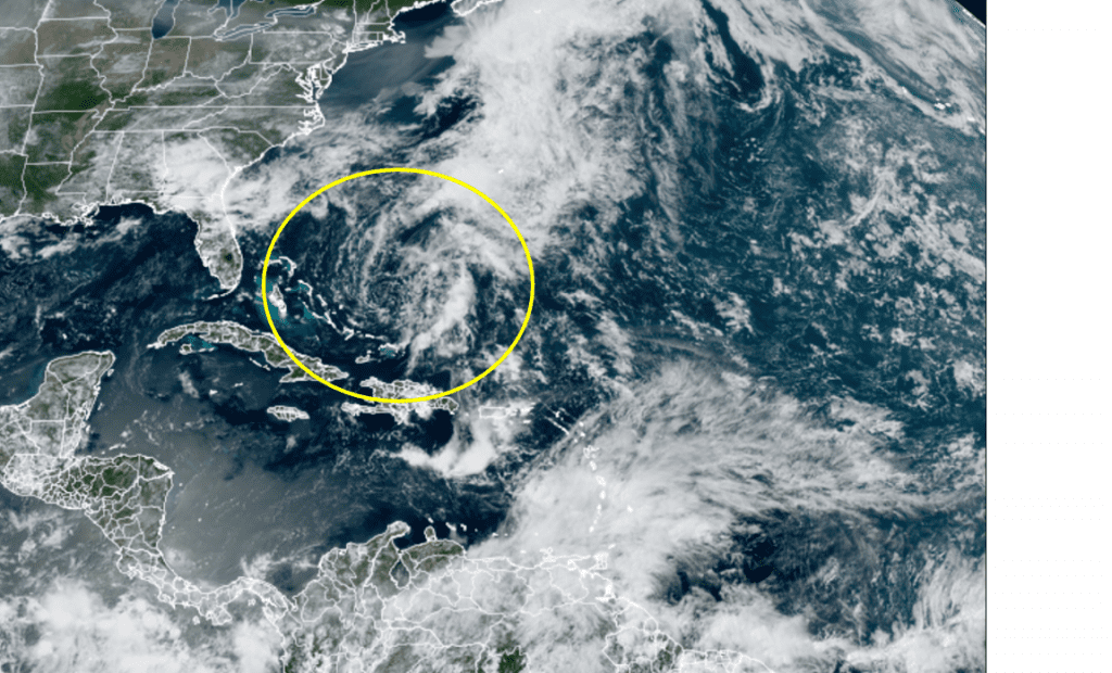
NOAA/RAMMB/CIRA 05/22/2023 1:20 pm CDT
Elsewhere, conditions are quiet and tropical cyclone development is not expected through Memorial Day.
Have a good week.
Bob
Social Media