Rain and thunderstorms spread over parts of the region beginning Thursday afternoon as a weak cold front moved to the south. Through 10 am Friday, most totals have been between a tenth and a half inch. But according to LCRA’s Hydromet, more than a dozen locations recorded totals of 1-1.5 inches. The big winner so far has been a gauge located to the west of Brady, near Melvin, in McCulloch County. This gauge has picked up 3.50 inches.
More rain showers and thunderstorms are forecast across the region this afternoon and evening. Friday’s analysis showed Thursday’s cold front has stalled out across Central Texas, with considerable moisture spreading north from the Gulf of Mexico. Today’s moist and somewhat unstable air mass is expected to cause the development of scattered rain showers and thunderstorms. The probability for rain will be near 50-60 percent across the Hill Country and Central Texas regions, and near 70-80 percent across the coastal plains. The rain is predicted to taper off shortly after sunset. The threat for strong to severe storms has eased some compared to Thursday. But a few of today’s storms could still produce strong and gusty winds. Totals through Friday evening are forecast to average between 0.25 and 0.5 inches, with isolated totals of 2-3 inches possible—especially towards the coast.
Friday’s temperature is predicted to only warm to around 90-92 degrees.
A break from the widespread, rainy pattern can be expected Saturday through Sunday afternoon as the cold front lifts back to the north and a weak ridge of high pressure temporarily spreads back across Texas. However, tropical moisture lingering across the area will lead to some scattered rain showers and thunderstorms on Saturday and Sunday afternoons. The probability for rain will be 20 percent Saturday and 30 percent Sunday. Totals on both days are forecast to average around a quarter inch or less. Expect a partly cloudy sky both days. Temperatures are predicted to reach the mid and upper 90s.
A prolonged stretch of unsettled weather, featuring periods of rain and thunderstorms is predicted for our region next week. Forecast solutions call for a large trough of low pressure in the middle atmosphere to spread south into northern and eastern Texas early next week, with the trough predicted to linger over the state through late week. Ridges of high pressure on both sides of the trough will help pull considerable moisture north from the Gulf, creating a favorable environment for the development of rain showers and thunderstorms. The most favorable period for significant rain is expected to occur between Sunday night and Wednesday night, when rounds of moderate to occasionally heavy rain are expected.
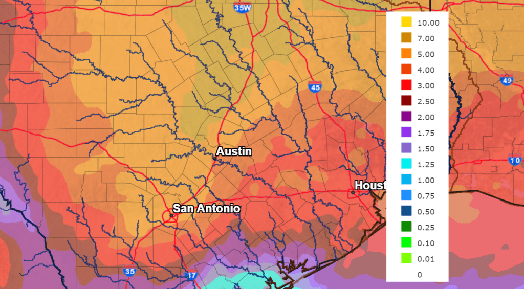
While there is still quite a bit of uncertainty in forecasted totals for next week, the latest data shows a potential for 1-2 inches of rain each day on Monday, Tuesday, and Wednesday. These totals could be enhanced further should tropical moisture from the system in the Gulf gets pulled north into our region. Next Thursday and Friday totals closer to 0.5 to 1 inch are forecast. Adding all of the daily rainfall together, the National Weather Service’s rainfall forecast through next Friday morning calls for totals to generally be in the range of 5-7 inches, with isolated totals to near 10 inches possible.
NWS Rainfall Forecast for the period 7 am Friday through 7 am next Friday:
Despite long-term drought conditions in place, slow-moving cells with intense rainfall efficiency next week may produce excessive runoff that could resulting in flooding. This flood threat will increase deeper into the event as the ground steadily saturates.
High temperatures next week are forecast to generally be in the upper 80s to low 90s.
Looking out into next weekend and the following week, forecasts call for a drier pattern, although a slight chance for scattered rain showers will continue. High temperatures are forecast to be mostly in the mid-90s.
Tropical Weather Update
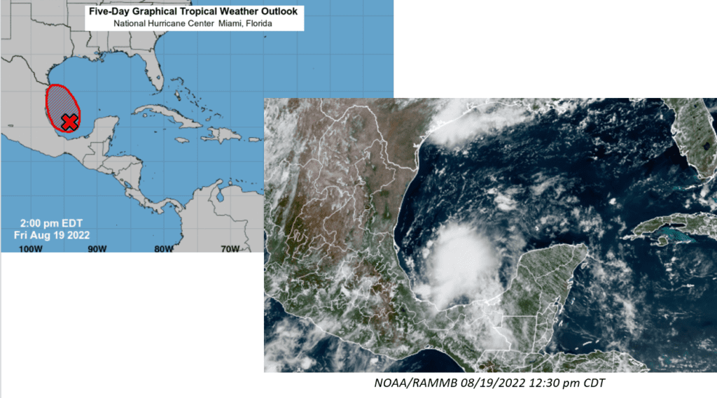
Friday’s satellite imagery showed showers and thunderstorms associated with the broad low pressure area over the southwestern Gulf of Mexico and the Bay of Campeche becoming better organized. Environmental conditions now appear favorable for additional development, and a tropical depression could form later today, tonight or on Saturday as the system moves northwestward across the southwestern and western Gulf of Mexico. NHC forecasters are giving the system a 70 percent chance for tropical development through Saturday.
However, by Saturday night, the system is expected to move inland over northeastern Mexico, which will end its chances for development. An Air Force
Reserve Hurricane Hunter aircraft is scheduled to investigate the system this afternoon.
Some of the moisture from this tropical system could spread north into South Texas by early next week, enhancing the threat for significant rain.
Have a good weekend.
Bob
Social Media