It’s been a wet week across the region, with most areas picking up some beneficial, soaking rains. This wet pattern looks to continue through the weekend, with periods of rain showers and thunderstorms—primarily in the afternoon and evening hours each day. Locally heavy rain will be possible at times. Friday’s weather maps showed Texas currently sandwiched between ridges of pressure located over the western and southeastern U.S. These two features along with a weak trough over the Plains states are funneling a considerable amount of moisture north into Texas. Small waves of low pressure sliding into Texas from the trough, a slow-moving cold front, and a nearly saturated atmosphere are predicted to be the triggers for the development of rain this afternoon, through early next week.
As or early Friday afternoon, scattered rain showers and thunderstorms have been most numerous across the northern third of the state, with only isolated activity occurring across Central Texas and the Hill Country. The rain seems to be focusing on a weak cold front draped east-west across North Texas. For Friday afternoon into Friday night, high-resolution forecasts call for the most widespread rains to continue across North Texas, the northern Hill Country and the Concho Valley regions. Across the Hill Country, Central Texas and coastal regions, scattered rain showers and thunderstorms are forecast to develop through the afternoon and evening hours, with the probability for rain near 50 percent. Rain totals through sunrise Saturday are forecast to average between 0.25 and 0.5 inches, with isolated totals up to 2 inches possible. Do note that any storms which develop will have the potential to be slow-movers, capable of producing large amounts of rain in a short period of time.
A more widespread coverage or rain and thunderstorms is forecast for the Hill Country, Central Texas, and coastal regions over the weekend and Labor Day as the weak boundary currently across North Texas, sags to the south and stalls somewhere just north of Interstate 10. Forecasts call for the coverage of rain to decrease some across the northern half of the Hill Country Sunday and Monday, while scattered to numerous showers and thunderstorms persist across the southern half of the Hill Country, Central Texas and coastal regions. This is due to the boundary sinking further to the south. The most favorable period for rain and storms is predicted to be in the afternoon and evening hours. It is not expected to be an all-day rain. There will be breaks in the precipitation from time to time.
High temperatures Saturday through Monday are forecast to generally be near 88-92 degrees.
- The probability for rain Saturday is forecast to be near 70 percent across the region.
- The probability for rain Sunday and Monday is forecast to be around 50 percent across the northern half of the Hill Country, but remain near 70 percent across the rest of the region.
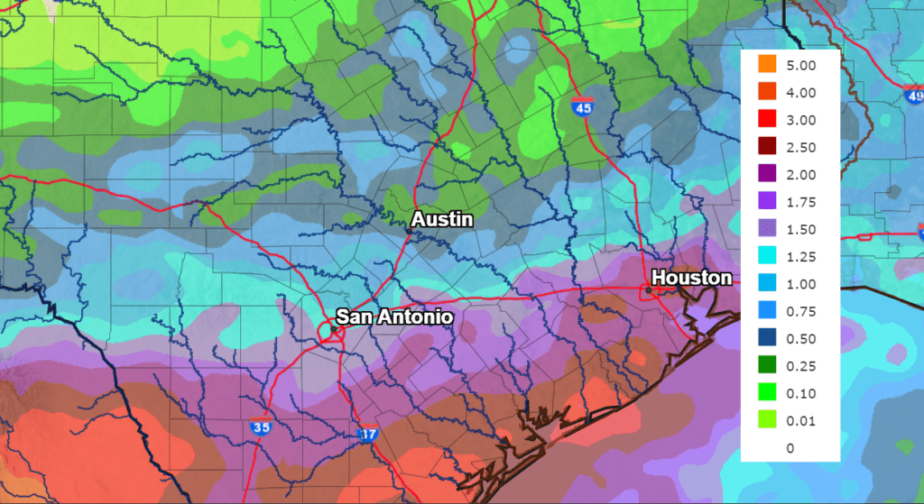
General totals through Monday evening are forecast to average between 1 and 1.5 inches across the Hill Country, between 1 and 2 inches across Central Texas, and between 2 and 4 inches across the coastal plains.
NWS Rainfall Forecast for the Period 7 pm Friday through 7 pm Monday:
Next Tuesday through Friday, forecasts call more scattered afternoon showers and thunderstorms across the region. However, the coverage and magnitude of the rain is expected to be less as a weak ridge of high pressure tries to expand east out of the Desert Southwest. The probability for rain looks to be highest towards the coast at 50-60 percent, and lowest across the Hill Country at 30-40 percent. Expect a partly to mostly cloudy sky with high temperatures generally in the low 90s.
Of possible interest to our region late next week into next weekend will be influence from a potential tropical cyclone out of the eastern Pacific. National Hurricane Center forecasters are closely monitoring an area of disorganized showers and thunderstorms extending several hundred
miles south of the coast of southern Mexico. NHC forecasters are calling for gradual development of this disturbance, and a tropical depression could form this weekend or early next week as the system moves westward and then west-northwestward near the coast of southern and southwestern Mexico. Long-range forecasts call for the system to track northwest through the Gulf of California and up to northern Mexico and southern Arizona next weekend. It is possible some of the middle and high-level moisture from this system will spread across Texas next weekend, enhancing the chance for widespread rain locally. There is much uncertainty with this scenario. Stay tuned for further updates.
Tropical Weather Update
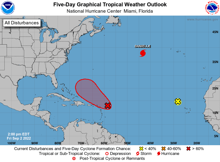
The National Hurricane Center is currently monitoring Hurricane Danielle, located about 900 miles west of the Azores, an area of disturbed weather located east of the Lesser Antilles, and another area of disturbed weather northwest of the Cabo Verde Islands. None of these system will pose a threat to the Gulf of Mexico or the Texas coast through early next week.
By the way, Hurricane Danielle is the first hurricane of the 2022 Atlantic hurricane season. Danielle ends the hurricane drought which has persisted for the past 332 days. This is the third longest gap between hurricanes in the historical record.
I hope everyone has a safe and enjoyable holiday weekend!
Bob
Social Media