…The much advertised blast of arctic air has arrived…
…A Winter Storm Warning Remains in effect for the Hill Country and Central Texas regions, including Austin, through 9 pm Thursday….
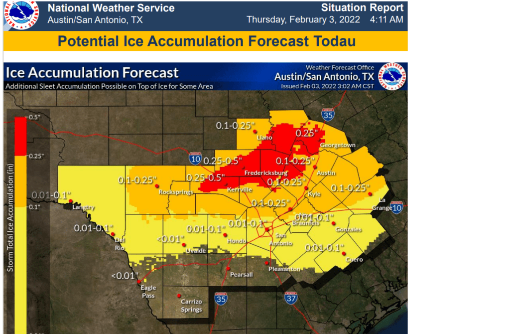
…Significant icing is expected, with a mix of freezing rain and sleet. Ice accumulations of 1/10 to 1/4 inch are on average expected, with isolated higher amounts up to 1/2 possible. Total sleet accumulations of 1/4 to 3/4 inch will be possible, especially across the Hill Country…
…A Winter Weather Advisory is in effect of Fayette County and the middle Texas coast, including Matagorda County, from 2pm Thursday, to noon Friday…
…Bitterly cold temperatures forecast Thursday Night and Friday Night….
This morning, freezing rain and sleet are ongoing across the Hill Country and across Central Texas regions. Icing impacts to roads has been reported at several locations. So far, the precipitation southeast of La Grange has been all rain as temperatures have hovered around 35-40 degrees. This is expected to change later this afternoon. Also, overnight a band of heavier rain developed along the I-35 corridor from San Antonio, to Austin. According to LCRA’s Hydromet, totals of 2-2.75 inches were recorded across Travis County. Some low water crossing were still reported flooded as of late morning, so use caution if you attempt to travel today.
As of late morning, Doppler radar showed widespread light precipitation occurring across the Hill Country and Central Texas regions. This precipitation has so far mainly been freezing rain and sleet. Confidence has increased that a changeover from freezing rain to sleet will take place from west to east late this morning through mid to late afternoon across the Winter Storm Warned area as the upper trough moves over our region. As of late morning, the back edge of the precipitation was located over the western and northern Hill Country. The precipitation is predicted end across the central and eastern Hill County early to mid-afternoon, and across the Austin/Central Texas region mid to late afternoon.
For the Hill Country and Central Texas regions, significant icing is expected this afternoon, with a mix of freezing rain and sleet occurring across the area. Ice accumulations of 1/10 to 1/4 inch are expected on average, with isolated higher amounts up to 1/2 possible. Total sleet accumulations of 1/4 to ¾ inch will be inch possible, especially across the Hill Country. Travel could be very difficult on untreated roads, especially elevated bridges, overpasses, and roadways. Sidewalks and pavement will be slippery to walk on. Significant icing could lead to tree damage and isolated to scattered power outages. In addition, winds could gust as high as 35 mph today through Friday, producing wind chill values ranging from near 0 degrees, to the teens today through Friday night.
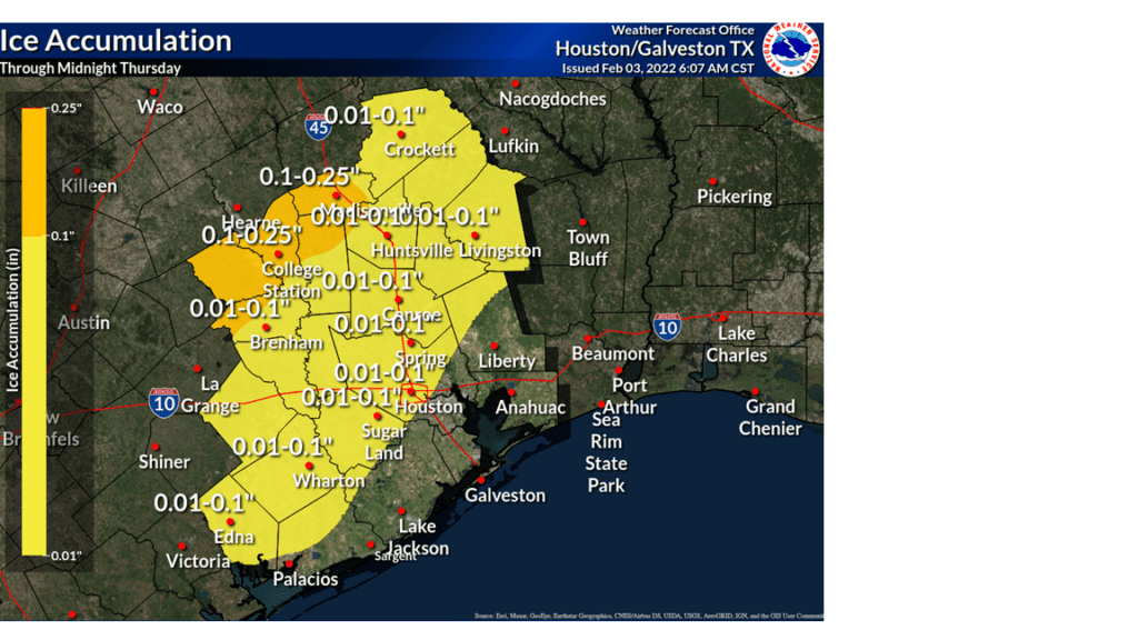
Across the coastal plains region, including Fayette County, the Winter Weather Advisory has now been expanded to inland portions of Matagorda, Brazoria, and Jackson counties this evening. With temperatures forecast to fall below freezing this afternoon and tonight, a mixture of rain, freezing rain and sleet are forecast this afternoon and tonight. Ice accumulations to around a tenth of an inch are forecast for Fayette and Colorado counites For Wharton and Matagorda counties, ice accumulations of just an icy glaze are forecast. Even this light amount of ice could cause hazardous driving conditions this evening and overnight. The precipitation is forecast to taper off here late Thursday night into early Friday morning.
We will likely see little movement in the temperature this afternoon due to the thick clouds and light precipitation. Readings are forecast to remain below freezing this afternoon—mostly in the low and mid-20s across the Hill Country. Readings look stay below freezing here till early Saturday afternoon. Across Central Texas, readings are forecast to remain around 30 degrees this afternoon, and remain below freezing till mid or late afternoon Friday. High temperatures Friday will generally be around 32-33 degrees. Across the coastal plains, readings are predicted to fall below freezing by this evening and remain below freezing till about midday Friday. A mostly sunny to partly cloudy sky is forecast Friday.
Sunny, dry and cold weather is forecast this weekend into early next week:
- Low temperatures Friday and Saturday mornings are forecast to be between 10 and 15 degrees across the Hill Country, near 18-20 degrees in the Austin/Central Texas region and be the mid-20s coastal region.
- High temperatures Friday are forecast to near 30 degrees across the Hill County ,near 32-33 degrees across Central Texas and near 40 degrees near the coast.
- High temperatures Saturday are forecast to be in the low 40s Hill Country and Central Texas regions, and the low 50s towards the coast.
- Lows Sunday morning will include the mid and upper teens across the Hill Country, the low 20s across Central Texas area, and the upper 20s near the coast.
- High temperatures Sunday and Monday are forecast to near 48-50 degrees.
- Lows Monday morning will range from the low 20s west to the mid-30s near the coast.
Bob
Social Media