Friday afternoon’s observations didn’t show a significant change in the structure of tropical depression 14, compared to Friday morning. A low-level swirl on which the Air Force reconnaissance plane made its last fix has apparently become the new center of circulation of the depression. Satellite wind measurement showed winds of 25-30 knots to the northeast of the new center, so the system remains a tropical depression.
As of 4 pm CDT, the center of Tropical Depression Fourteen was located about 255 miles southeast of Cozumel, Mexico. The depression is moving toward the northwest near 13 mph. A slower northwestward motion is expected over the next couple of days, followed by an increase in speed by Sunday and Monday. Maximum sustained winds are near 35 mph with higher gusts. Strengthening is forecast during the next couple of days, and the depression is expected to become a tropical storm sometime tonight. The system could be near hurricane strength when it reaches the Yucatan Peninsula of Mexico late Saturday. Additional strengthening is forecast Sunday and Monday as the system moves over the central Gulf of Mexico.
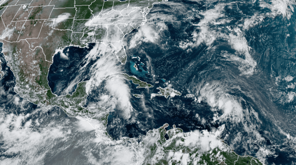
RAMMB-CIRA 08/21/2020 3:20 pm CDT
The latest forecast track calls for the center of the system will approach the east coast of the Yucatan Peninsula of Mexico on Saturday. The center will then cross the northeastern part of the Yucatan Peninsula Saturday night and move over the central Gulf of Mexico toward the northwestern Gulf on Sunday and Monday.
There has been a change in the forecast track for early next week. The National Hurricane Center noted there was a notable westward bend in several of the global forecast track solutions this afternoon, (particularly the GFS and ECMWF). Based on this and some other factors, the latest outlook calls for the tropical storm to now most likely make landfall somewhere along the middle to upper Texas coast—in the area between Sargent and Freeport Tuesday afternoon. The cone of uncertainty at landfall now stretches from about Port Mansfield, Texas to Vermillion, Louisiana. Once inland, the system is forecast to move to the northwest Tuesday night, reaching a position near Austin Wednesday afternoon at tropical depression intensity.
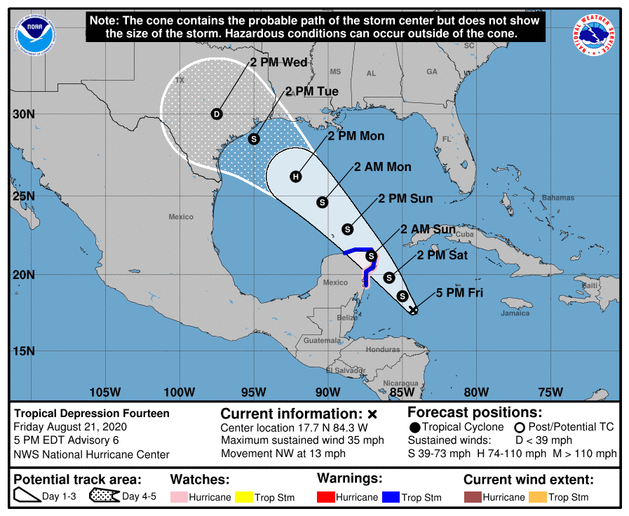
This more westward path means the middle Texas coast, the Austin/Central Texas area and the Hill Country will all likely see impacts from the tropical cyclone in the form of wind and moderate to heavy rain.
Tropical Storm force winds will be possible along the middle Texas coast as early as Monday afternoon, with the strong winds continuing into Tuesday. Tropical storm force winds are forecast to spread further inland to the Columbus/La Grange late Monday night. Strong, but weaker winds are forecast to spread into the Austin/Central Texas area Tuesday afternoon into Tuesday night.
Based on the new track, widespread and more significant rain amounts can be expected from the middle Texas coast through Central Texas and into the Hill Country beginning Monday night, continuing through Wednesday. Several inches of rain will be possible across the region if this forecast track holds into next week.
I will caution not to buy into the latest track 100 percent. There is still much uncertainty with this system and the influences that are steering it. The computer-forecast solutions should begin to converge on a more consistent solution over the weekend. Stay tuned for further updates this weekend.
Tropical Storm Laura
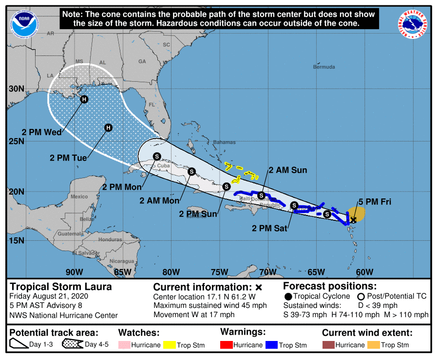
Today’s forecast data also showed a westward shift in the forecast track for Laura. As of 4 pm, the tropical storm was centered about 40 miles east of Antigua. Laura is moving toward the west near 17 mph and a general west-northwestward motion at a faster forward speed is expected over the next couple of days. On the forecast track, the center of Laura will move near or over portions of the Leeward Islands later today, near or over Puerto Rico Saturday morning, and near the northern coast of Hispaniola late Saturday and early Sunday. Maximum sustained winds are near 45 mph with higher gusts. Some slow strengthening is forecast during the next 48 hours.
The outlook for Tuesday and Wednesday now calls for Laura to move to the north central Gulf of Mexico and possibly make landfall as a hurricane somewhere over the southeastern coast of Louisiana.
Have a good weekend and be sure to stay abreast of the latest National Hurricane Center updates as we go through the weekend.
Bob
Social Media