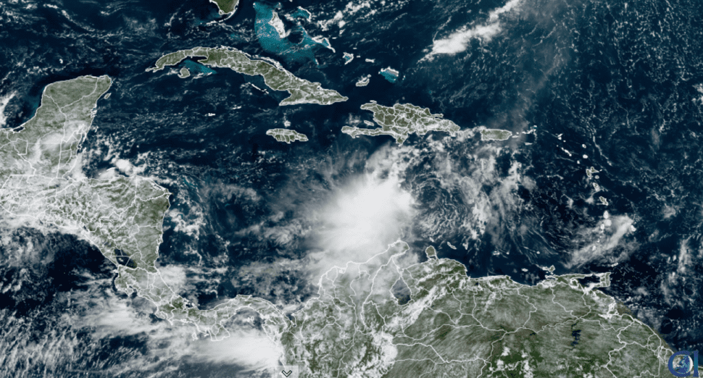
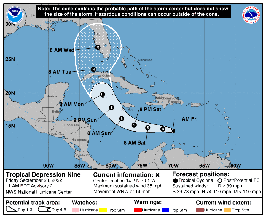
The strong tropical wave in the Caribbean Sea which forecasters have been monitoring for the past few days has strengthened into a tropical depression. The system possesses a well-defined circulation with strong thunderstorms mainly on the west side of the center. As of late Friday morning, tropical depression Nine was located over the Caribbean Sea, roughly 515 miles east-southeast of Kingston, Jamaica. Maximum sustained winds were near 35 mph with higher gusts. Some slow strengthening is forecast today through Saturday, but more significant intensification is forecast Sunday into Monday. The depression is predicted to become a tropical storm Friday night, and a hurricane sometime Sunday night.
NOAA/Colorado State University/RAMMB 09/23/2022 11:40 am CDT
The depression is currently moving toward the west-northwest near 14 mph. A more westward motion is expected to begin later today and continue through Saturday, followed by a turn toward the west-northwest and northwest Sunday and Monday. On the forecast track, the center of the cyclone is forecast to move across the central Caribbean Sea through Saturday, pass south of Jamaica Saturday night and Sunday, then approach the Cayman Islands Sunday night and early Monday.
The forecast path beyond Monday is still somewhat uncertain. However, based on the latest National Hurricane Center forecast and computer-model solutions, it appears a track toward the western Gulf of Mexico and the Texas coast is pretty remote. A trough of low pressure digging south across the eastern U.S. is predicted to pull the tropical system to the north and northeast—not allowing it to move into the western Gulf. NHC’s 5-day forecast calls for the system to make landfall somewhere along the Florida peninsula late Tuesday or Wednesday, with the highest likelihood being somewhere along the peninsula’s west coast.
Across Central Texas, weather conditions continue to be very quiet. The heat is going to be the area’s biggest weather story through the weekend. A ridge of high pressure, or heat dome, of July-like intensity is in place across much of the southern U.S. The ridge is forecast to remain in place through Saturday, then begin to weaken and shift to our west on Sunday. This will translate to more sunny, dry, and hot weather for our area through the weekend. Expect light south and southwesterly breezes at 5-10 mph.
- High temperatures Friday through Sunday are forecast to be in the mid-90s across the Hill Country, be in the range of 98-100 degrees across Central Texas, and be in the mid-90s across the coastal plains.
A trough of low pressure is forecast to dig south through the middle Mississippi Valley region late Sunday. This trough will help push a cold front southeast across Texas late Sunday into Monday. The front is forecast to push off the middle Texas coast Monday afternoon. Unfortunately, with limited moisture in place, no rain is expected with the cold front. Monday’s weather will be sunny and warm. High temperatures will range from around 90 degrees across the northern Hill Country, to the mid-90s across the coastal plains.
Sunny and dry weather will be in place next Tuesday through Friday as a very stable atmosphere sets up across Texas. Monday’s cold front will being drier and just slightly cooler air for the week. While the afternoons will still be warm, the nighttime should be noticeably cooler.
- High temperatures next Tuesday through Friday are forecast to be in the upper 80s across the Hill Country, in the low 90s across Central Texas and the middle Texas coast.
- Low temperatures Tuesday through Saturday mornings are forecast to be near 58-60 degrees across the Hill Country, and in the low 60s across Central Texas and the coastal plains.
Sunny, dry and warmer weather is forecast next weekend and the week of October 3rd as a ridge of high pressure spreads back across Texas. Expect high temperatures to be in the low to mid-90s, and lows around 70 degrees.
Tropical Weather Update
In addition to Tropical Depression Nine, National Hurricane Center forecasters are also following major hurricane Fiona, headed toward Atlantic Canada, and tropical storm Gaston located northwest of the Azores.
A broad area of low pressure is located several hundred miles west-southwest of the Cabo Verde Islands. This system continues to produce disorganized shower and thunderstorm activity. Despite marginal environmental conditions, some slow development of this system will be possible over the next several days while it drifts northwestward or northward over the central tropical Atlantic. NHC forecasters are giving this system a 30 percent chance for tropical development over the next 5 days.
Finally, shower and thunderstorm activity associated with an area of low pressure located between the Cabo Verde Islands and the west coast of Africa is showing increased signs of organization. Environmental conditions are forecast to be generally conducive for further development during the next day or so, and a tropical depression is likely to form while the system moves northward at about 10 mph, roughly parallel to the coast of west Africa. NHC forecasters are giving this system an 80 percent chance for tropical development over the next 5 days.
Mars Has Returned to the Evening/Nighttime Sky
After spending several months in the early morning sky, Mars is now joining Jupiter and Saturn in the nighttime sky. Mars, shining at magnitude –0.6 is located in Taurus. It rises between 10 and 11 pm and gains altitude for the rest of the night. Mars is four times as bright as Mars-colored Aldebaran, magnitude +0.9, sparkling to its right.
Enjoy this first weekend of autumn! (although it will feel more like the middle of summer)
Bob
Social Media