…A Tropical Storm Warning is in effect from Port Aransas, Texas to Morgan City Louisiana, including the inland counties of Matagorda and Wharton…
…A Flash Flood Watch has been posted for all of Southeast Texas, including Fayette, Colorado, Wharton and Matagorda Counties through Tuesday evening…
Discussion
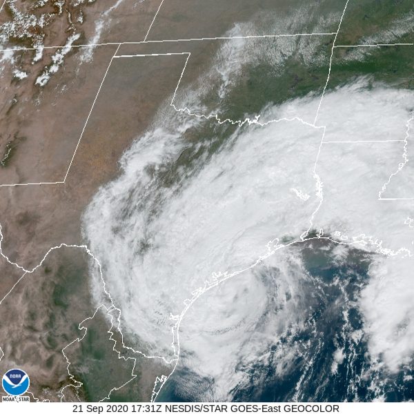
Tropical Storm Beta is expected to make landfall near Matagorda Bay, along the middle Texas coast, this evening. While there was little thunderstorm activity near the center of Beta overnight, thunderstorms have recently begun to develop near the center, but it is unlikely that Beta will intensify much before landfall. Dry air continues to work into and wrap around the large wind field of Beta, and this is producing a disorganized precipitation field around the system. After moving inland, Beta is forecast to slow down and become nearly stationary tonight through about midday Tuesday in the vicinity of Matagorda and Wharton Counties. Very heavy rain and tropical storm-force winds are expected during this time. Beta is forecast to move off to the northeast late Tuesday into Wednesday, taking most of the rain with it.
Current Situation
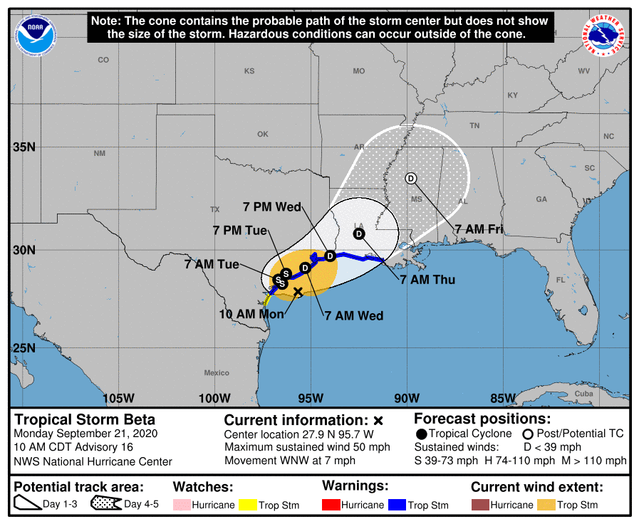
As of 10 am CDT, the center of Tropical Storm Beta was located by an Air Force Reserve reconnaissance aircraft and NOAA
Doppler weather radars about 55 miles southeast of Port O’Connor, Texas. Beta was moving toward the west-northwest near 7 mph, and this general motion is forecast to continue today. A decrease in forward speed and a sharp turn to the north and northeast is expected on Tuesday. Data from the aircraft and Doppler radars indicates that maximum sustained winds have decreased to near 50 mph with higher gusts. Little change in strength is forecast before Beta reaches the Texas coast this evening. Weakening is anticipated once Beta moves inland.
Tropical-storm-force winds extend outward up to 175 miles from the center. A Texas TCOON observing site at Port O’Connor, Texas, has recently measured a wind gust to 40 mph. A NOAA buoy located just east of Galveston, Texas, has reported a sustained wind of 39 mph and a gust to 43 mph during the past couple of hours.
As of 10 am, LCRA’s Hydromet showed several gauges across Wharton and Matagorda Counties have recorded 24-hour rain totals between 1 and 1.25 inches. Most gauges between Austin and Wharton have recorded totals between 0.5 and 1 inch. A number of gauges around the Austin area have recorded totals between 0.25 and 0.5 inches. Across the Hill Country, most totals have been near or less than a tenth of an inch.
Forecast Track
Beta is now moving to the west-northwestward at a slightly faster forward speed of about 7 mph. Forecasts call for the center of Beta to continue moving west-northwestward this afternoon, with the center predicted to move inland close to Matagorda Bay this evening. Once inland, steering currents are forecast to collapse and Beta is forecast to stall for several hours close to the middle Texas coast. Beta is expected to slowly turn to the northeast Tuesday and reach the Houston area on Wednesday.
Impacts and Rainfall
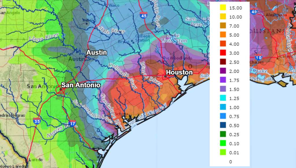
Rain bands associated with the tropical storm are forecast to spread northwest from the coast into Central Texas this afternoon through Tuesday night. However, the heaviest rains are forecast to develop across the Matagorda/Wharton/Colorado County area, close to where the center of Beta pushes inland. Periods of heavy rain are forecast to develop this afternoon and continue through Tuesday night. Rainfall will taper off across the Hill Country and most of Central Texas Tuesday night, with just a slight chance for rain lingering on Wednesday. Towards the coast, the chance for rain will decrease Wednesday morning, with just a slight chance for rain lingering late Wednesday into Thursday.
Tropical storm conditions are forecast to develop across Wharton and Matagorda Counties this afternoon and continue into Tuesday. Northeasterly winds will increase to near 25-35 mph, with occasional gust to 45/50 mph.
Due to large amount of dry air that has been drawn into the circulation of Beta, rain totals are not expected to be quite as heavy as were originally forecast. Here is a breakdown of forecasted totals through late week by region:
- For the Hill Country, totals should average around a half inch, or less
- For the Austin area, totals should average around 1-1.5 inches.
- For the area between Bastrop and La Grange, totals should average 2-3 inches.
- For the area between La Grange and Columbus, totals should average between 2 and 5 inches.
- For the area from Columbus to La Grange, most totals should average between 3 and 5 inches,
- For the area from Bay City to the coast, totals should average between 5 and 10 inches along with isolated heavier totals.
NWS Rainfall forecast for the period 7 am Monday through 7 am Thursday:
Water levels remain high along the middle and upper Texas coast. A storm surge warning remains posted for the middle Texas coast through Tuesday afternoon, where a storm surge of 2-4 feet is forecast.
Bob
Social Media