…A Tropical Storm Warning has been posted for the Texas coast from Port Aransas to High Island along with the inland counties of Matagorda and Wharton…
…A Flash Flood Watch has been posted for much of Southeast Texas, including Fayette, Colorado, Wharton and Matagorda Counties from Sunday evening through Tuesday evening…
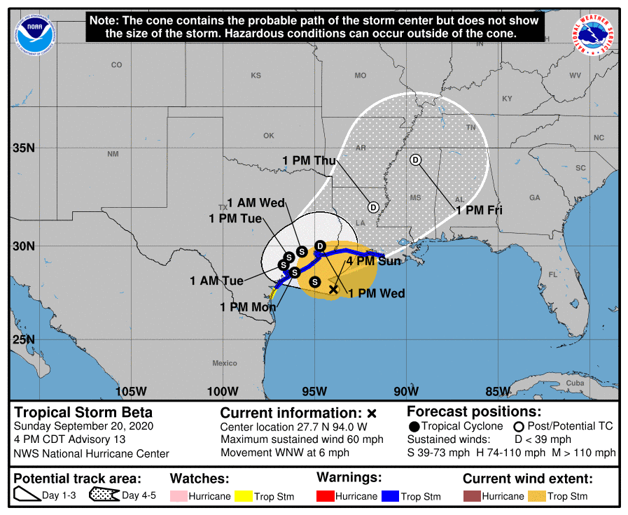
Tropical Storm Beta continues unchanged over the western Gulf of Mexico. Satellite data indicated the storm attempted to strengthen this afternoon and in the process ingested a large amount of dry air which has limited any additional strengthening. Forecasts for Beta have not changed significantly since Saturday, with the system forecast to move inland as a tropical storm near Matagorda Bay Monday evening. Beta is expected to weaken and slowly move northeast along the middle and upper Texas coast Tuesday into Wednesday. Very high totals of rain are still forecast for the coastal plains region.
As of 4 pm Sunday, the center of Tropical Storm Beta was entered in the western Gulf of Mexico, about 150 miles east-southeast of Port O’Connor, Texas. Beta was moving toward the west-northwest near 6 mph, and this general motion is forecast to continue for the next day or so. A decrease in forward speed and a sharp turn to the north and northeast is expected Monday night and Tuesday. Data from an Air Force reconnaissance aircraft indicates maximum sustained winds are near 60 mph, with higher gusts. Little change in strength is forecast during the next couple of days before Beta reaches the Texas coast. But weakening is anticipated Monday night into Tuesday once Beta moves inland.
Sunday’s forecast data and the National Hurricane Center official forecast this afternoon did not show much appreciable change with respect to the track for Beta. The system remains in an area of weak steering currents, caught between a ridge of high pressure over Florida and a weaker ridge located over the southern Plains states. The ridge of high pressure over Florida is forecast become the strongest of the two ridges and continue to nudge the tropical storm northwestward to the middle Texas coast and about 25-30 miles inland Monday night into Tuesday morning. The Florida high pressure system is forecast to turn Beta to the northeast across the coastal plains region Tuesday, followed by a faster northeastward motion Wednesday through Friday.
Based on the latest forecast, the center of Beta is forecast to track inland very close to, if not directly over Matagorda and Wharton Counties Monday night into Tuesday morning, with the center slowly tracking northeast across Fort Bend and Austin Counties on Tuesday, pushing east across the Houston/Harris County on Wednesday.
Tropical storm conditions are forecast to develop across Matagorda and Wharton counties tonight and continue Monday into Tuesday afternoon. Expect northeast winds to increase to around 35-45 mph, with occasional gusts to 55 mph through the period. Showers and thunderstorms will increase across the area Sunday night. Very heavy rain and scattered thunderstorms will develop Monday and continue through Tuesday afternoon. The rain will decrease in intensity and areal coverage on Wednesday.
For the area between La Grange and Columbus, showers and thunderstorms will spread over the area tonight. Tropical storm force conditions will be possible Monday into Tuesday. Expect northeasterly winds at 30-35 mph, with occasional gusts to 45 mph. Periods of very heavy rain are forecast Monday through Tuesday afternoon. The rain will decrease in intensity and area coverage Tuesday night through Wednesday.
From the eastern Hill Country to La Grange, showers and isolated thunderstorms will spread into the area Sunday night, with rain and thunderstorm activity increasing in areal coverage and intensity Monday through Tuesday afternoon. The rain will decrease in intensity and area coverage Tuesday night through Wednesday.
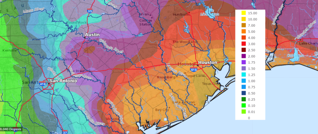
Forecasted rainfall totals between Sunday night and late week have not changed appreciably with the latest update.
- For the eastern Hill Country region, totals of 0.5-1 inch are forecast.
- For the Austin and Interstate 35 corridor, totals of 1-2 inches are forecast.
- For the area between Bastrop and La Grange, totals of 3-5 inches are forecast.
- For the area between La Grange and Columbus, totals of 5-8 inches are forecast.
- For Wharton and Matagorda Counties, totals of 8-12 inches are forecast. Isolated heavier totals will be possible.
NWS rainfall forecast for the period 7 pm Sunday through 7 pm Friday:
Bob
Social Media