Major changes were made this afternoon to the National Hurricane Center’s track for tropical storm Marco. The new NHC track forecast has been shifted significantly eastward, away from Texas, showing the center of Marco reaching southeastern Louisiana in about 2 days. This is the same scenario shown by a majority of the global forecast solutions. National Hurricane Center forecasters do caution considerable uncertainty remains in this latest outlook. Various ensemble members from some of the global models still show a potential risk to the coast anywhere from Texas to Alabama, and it’s entirely possible that the volatile shift seen in the models today could continue into Sunday.
AT 4:00 pm CDT, the center of Tropical Storm Marco was located about 50 miles west of the western tip of Cuba. Marco is moving toward the north-northwest near 13 mph. Marco is expected to continue moving toward the north-northwest across the central Gulf of Mexico on Sunday, reaching the northern Gulf coast on Monday. Maximum sustained winds were near 65 mph with higher gusts. Strengthening is forecast during the next day or two, and Marco is expected to become a hurricane tonight or on Sunday. Marco is likely to still be at or near hurricane strength when it reaches the northern Gulf coast Monday afternoon. Weakening is forecast to occur as the center moves farther inland Monday night and Tuesday.
08/22/2020 2:30 pm CDT
The updated forecast track calls for Marco to reach the southeastern coast of Louisiana, to the southeast of New Orleans, Monday afternoon. After moving inland, Marco is expected to slow down and turn toward the northwest and west-northwest Monday night and Tuesday, moving across southern Louisiana into east Texas.
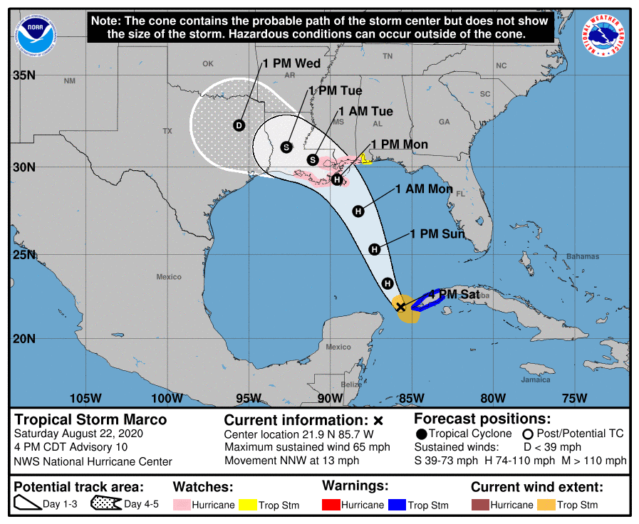
With this updated forecast track, Marco is expected to have little impact on weather conditions from the middle Texas coast into the Hill Country. Just a slight chance for rain showers is forecast across the region Tuesday through Thursday as the remnants of Marco move into Northeast Texas. Rain amounts should average around a quarter inch or less. Mostly sunny and hot weather looks to remain in place throughout the week.
Once again, I will echo the caution stated by National Hurricane Center forecasters to not get locked into the latest forecast track just yet. There is some potential the forecast track could swing back to the west in the next model runs. This is a very unusual weather situation with many competing forces on the storm that have yet to be completely resolved. Hopefully additional data from NOAA aircraft and weather balloon launches this evening will give us a more confident outlook Sunday morning.
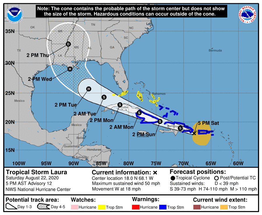
Tropical Storm Laura
Tropical Storm Laura is not expected to have any significant impact on our region’s weather. The latest forecast track calls for the system to move inland over south central Louisiana Wednesday, with the remnants lifting north into Mississippi and Arkansas on Thursday.
As of 4:00 pm CDT, the center of Tropical Storm Laura was located 100 miles west of Ponce, Puerto Rico. Laura is moving toward the west near 18 mph, and a generally west-northwestward motion is expected over the next few days. Maximum sustained winds are were 50 mph with higher gusts. No significant changes in strength are forecast during the next 48 hours while Laura moves near or over Hispaniola and Cuba. Some strengthening is forecast once Laura moves into the Gulf of Mexico Monday night and Tuesday.
The latest forecast calls for Laura to move away from Puerto Rico this evening, be near or over Hispaniola tonight, near or over Cuba Sunday and Monday, moving into the southeastern Gulf of Mexico Monday night and Tuesday. The updated track calls for Laura to make landfall along the south central coast of Louisiana Wednesday afternoon.
Bob
Social Media