A moist and unsettled weather pattern remains in place across much of Texas. Tuesday’s weather maps showed a large trough of low pressure situated over eastern New Mexico that is slowly lifting to the northeast. Smaller waves of pressure are circulating around the trough and are forecast to move across Texas this afternoon through Wednesday. Each of these waves is expected to cause the development of showers and thunderstorms that will track east across the area. While the main trough is forecast to lift north into the Plains states late Wednesday, a piece of the trough is forecast to break off and set up over South Texas late week and through the weekend. This feature is expected to pull considerable moisture north from the Gulf, causing the development of more rain showers and scattered thunderstorms.
This afternoon through Wednesday night is shaping up to be the wettest and stormiest period of the week as several waves of showers and thunderstorms develop and spread across the area. Some of the these storms may be strong to severe. Storm Prediction Center forecasters have placed the Hill Country and all of Central Texas under a Slight Risk (a 2 out of 5 risk) for severe thunderstorms through late tonight. On Wednesday, all of the region has been placed under a Marginal Risk (a 1 out of 5 risk) for severe thunderstorms. The primary severe threats will be large hail and damaging thunderstorm winds. The waves of rain and storms will also be capable of producing high totals of rain in a short period of time. Rainfall forecasts call for widespread totals of 1-3 inches this afternoon through sunrise Wednesday, and totals of 2-4 inches Wednesday through sunrise Thursday. Isolated heavier totals will not be out of the question. With the ground wet and in some cases saturated, this magnitude of rain will quickly runoff, increasing the threat for flash flooding. The National Weather Service has posted a Flash Flood Watch for the Hill Country, Central Texas and costal regions through Thursday afternoon.
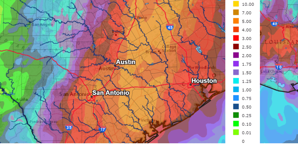
The National Weather Service’s rainfall forecast through 7 am Thursday calls for widespread totals of 3 to 4 inches from the eastern Hill Country to the middle Texas coast. Totals of 4-6 inches are forecast for the area stretching from around Victoria, to just east of Austin, to near Waco. Isolated totals of 8 inches or more will be possible.
NWS Rainfall Forecast for the Period 7 am Tuesday through 7 am Thursday:
A very unsettled weather pattern looks to continue Thursday through Saturday as that trough of low pressure sets up over South Texas, causing the potential for more periods of significant rain. Each day, waves of showers and thunderstorms are forecast to spread from the Gulf of Mexico north into Central Texas and the Hill Country. Occasional heavy downpours will be possible. Some strong to possibly severe storms will also be possible. Forecasts call for daily totals of around a half inch across the Hill Country and between 0.5 and 1 inch for areas along and east and Interstate 35. The probability for rain will be near 70 percent.
A slight chance for showers and thunderstorms is forecast Sunday through Monday. The weather pattern is expected to trend generally dry for next Tuesday and Wednesday.
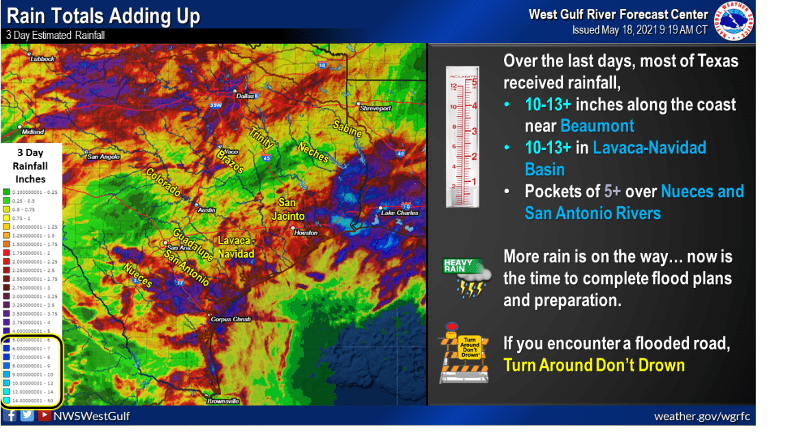
The following graphic produced by the National Weather Service West Gulf River Forecast Center shows the estimated amount of rain that has fallen across Texas over the past 3 days. Note the very high totals of rain which have fallen across northern Texas, Southeast Texas and the area between Uvalde and Corpus Christi. So far, totals haven’t been quite as heavy across the Hill Country and Central Texas, but this situation could quickly change over the next 48 hours. I urge everyone to stay weather aware and if you come across a flooded road, Turn Around, Don’t Drown.
Bob
Social Media