…A strong cold front is currently pressing south across our region. It will be bringing rain and thunderstorms, much colder temperatures, and windy conditions. Hill Country locations need to prepare for a light freeze Friday night and Saturday night…
The much anticipated cold front is currently pushing south through the state, with a 15-20 degree temperature drop occurring right along the front. At noon, the front was passing through the Austin/Interstate 35 corridor. It is forecast to reach the La Grange/Columbus area around 3-4 pm, and the coastal plains region early Friday evening.
A large area of rain and thunderstorms is occurring along and behind the cold front. Just after sunrise Friday morning , rain and storms spread over the area between San Angelo and Killeen. Some of the storms over parts of northern Burnet, Lampasas, and Bell Counties became severe, producing large hail of 1 to 2 inches in diameter and very heavy rain. LCRA’s Hydromet is showing totals of 1-2 inches across most of McCulloch and San Saba Counties, with lowers totals to the west
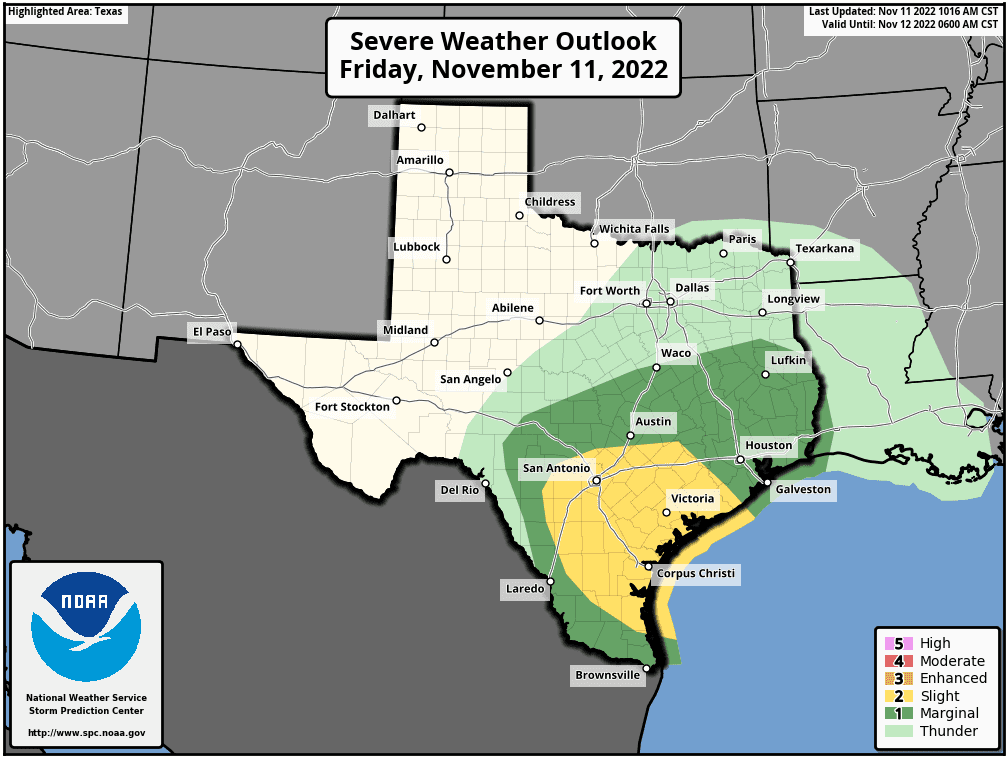
Severe Weather Threat
Additional strong to severe thunderstorms will be possible along and just behind the cold front as it pushes southeast across Central Texas and the middle Texas coast this afternoon and evening. A warm, moist, and fairly unstable atmosphere along the frontal zone may fuel the development of additional strong to severe thunderstorms. The primary severe weather threat will be large hail up to 2 inches in diameter, and strong straight-line winds. The Storm Prediction Center has placed the area southeast of a line stretching from northwest of San Antonio, to San Marcos, and Giddings under a Slight Risk (a 2 out of 5 risk) for severe thunderstorms through Friday evening. Areas north of the line have been placed under a Marginal Risk (a 1 out of 5 risk) for severe thunderstorms through Friday afternoon. The threat for severe storms should decrease about 2-3 hours behind the passage of the cold front as colder, more stable air spreads into the area.
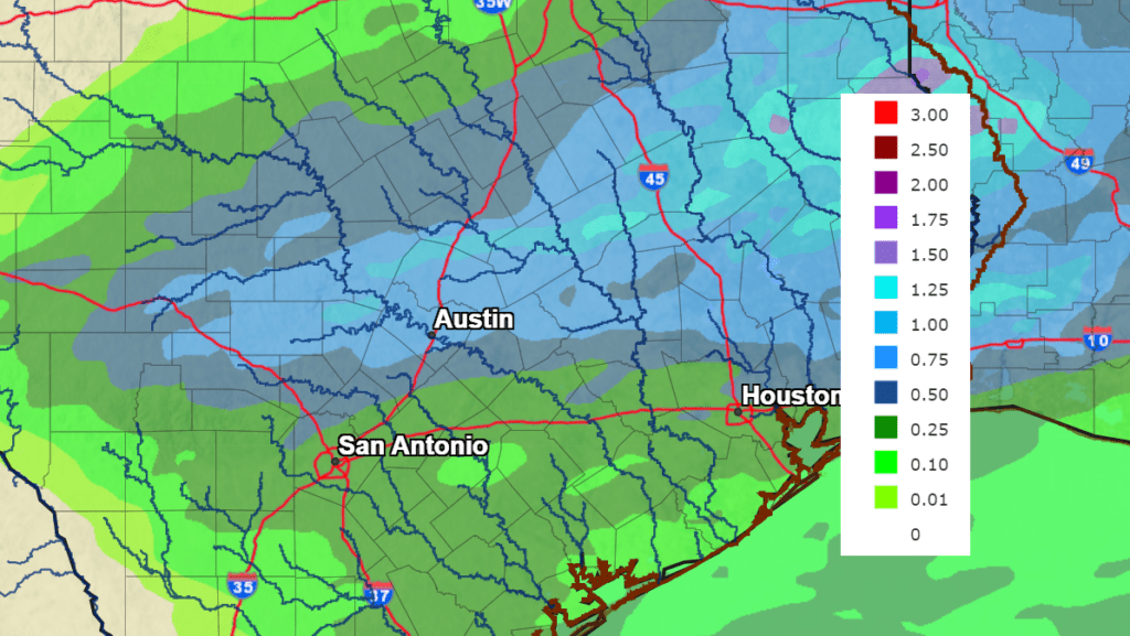
Rainfall
Widespread light to moderate rain showers and scattered thunderstorms are forecast to persist along and behind the cold front this afternoon and into tonight. High-resolution forecasts call for the rain to taper off across the Hill Country early this evening, across Central Texas late evening, and across the coastal plains region shortly after midnight. Forecasts call for rain amounts to be heaviest across the eastern Hill Country and Central Texas, where most totals will generally average between 0.5 and 1 inch. Isolated totals of 1-2 inches will be possible. Across the coastal plains region, totals are forecast to generally average between 0.25 and 0.5 inches.
NWS Rainfall Forecast for the Period 6 am Friday through 6 am Saturday:
Temperatures
Get ready for the coldest air mass so far this autumn. Ahead of the cold front, readings are predicted to warm into the 70s to low 80s. Behind the front, temperatures will quickly fall into the 50s. Readings across the Hill Country are forecast to fall into the mid and upper 40s by late afternoon. Clouds are forecast to clear from northwest to southeast after midnight Friday night, leading to a mostly clear Saturday and Saturday night. Expect a partly cloudy sky on Sunday.
The nighttime temperature forecast for the Hill Country has trended a bit lower and a light freeze is now predicted for much of the Hill Country on both Friday night and Saturday night.
- Lows Saturday morning are forecast to be in the low 30s across the Hill Country, in the upper 30s across Central Texas, and in the low and mid-40s across the coastal plains.
- High temperatures Saturday will range from the mid-50s across the Hill Country, to the low 60s near the coast.
- Low temperatures Sunday morning are forecast to be near 30-32 degrees across the Hill Country, in the mid-30s across Central Texas, and around 40-42 degrees across the coastal plains.
- High temperatures Sunday are forecast to be in the mid-50s to low 60s.
- Lows Monday morning are forecast to be in the mid-40s to around 50 degrees.
Wind
Expect strong northwesterly winds of 10-20 mph with gusts to 30 mph behind the cold front this afternoon, tonight and for much of Saturday. Wind speeds are predicted to decrease to around 5 mph Saturday night and Sunday.
Next Week
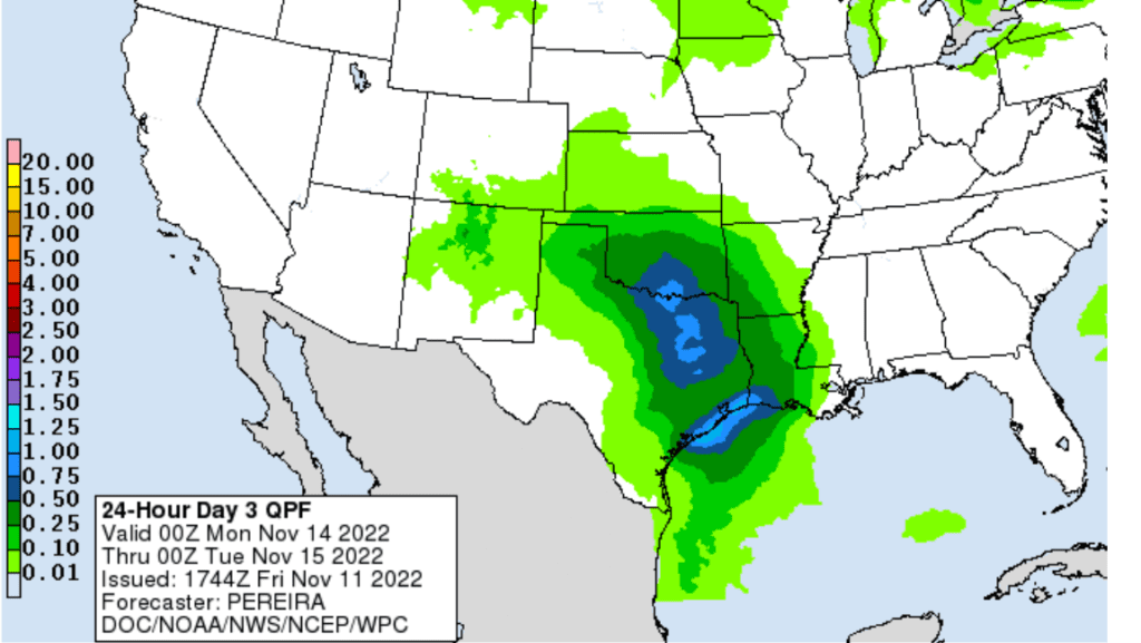
Light to moderate rain showers and isolated thunderstorms are forecast to develop across the region Monday into Monday evening as a passing trough of low pressure pulls clouds and moisture north from the Gulf of Mexico, resulting in an overrunning cloudy and wet pattern. The threat for any severe storms appears low. Rain amounts are forecast to be around a quarter inch or less across the Hill Country, and between 0.25 and 0.5 inches for areas along and east of Interstate 35. High temperatures Monday are forecast to be in the mid-50s.
NWS Rainfall Forecast for the Period 6 pm Sunday through 6 pm Monday:
A surge of cooler air will spread into the area Monday night and Tuesday in the wake of the trough of low pressure. Mostly sunny, dry, and cool weather is forecast Tuesday through Friday. Daily high temperatures are forecast to be in the low and mid-50s. Low temperatures will range from the mid-30s across the Hill Country, to the low 40s across the coastal plains.
Long-range forecasts indicate yet another surge of chilly air will push through our area next weekend that will keep temperatures below normal.
Have a good weekend!
Bob
Social Media