The weather pattern across Texas and the south central U.S. is very quiet in the wake of Tropical Storm Beta from earlier this week. A cool, fall-like air mass spread in behind the tropical storm and still remains in place. Low temperatures Friday morning dropped into the 50s across all of the Hill Country and Central Texas and reached the 60s across the coastal plains.
Sunny and dry weather is forecast to continue across our region this afternoon through Sunday. However, the temperature will be trending somewhat milder this weekend as southerly breezes make a return to the region. High temperatures are predicted to be in the mid to upper 80s this afternoon and be near 88-90 degrees on Saturday. Readings will be even warmer on Sunday, with highs ranging from the mid-90s across the Hill Country, to the low 90s across Central Texas to around 88-90 degrees towards the coast. Light wind speeds are forecast this afternoon and Saturday, with southerly winds increasing to 10-15 mph and gusting to around 25 mph Sunday.
A change in the weather pattern will be taking place early next week when a deep trough of low pressure dives into the southern Plains states out of the northern Rockies. This trough will help push a strong autumn cold front into Texas beginning late Sunday. The front is predicted to reach the northern Hill Country before sunrise Monday morning, then quickly push southeast across Central Texas between sunrise and noon. The front is forecast to push off the middle Texas coast Monday afternoon. Moisture convergence along the cold front looks to be just strong enough to produce a narrow band of light rain showers. The probability for rain will be near 20 percent across the Hill Country and Central Texas regions, and near 30-40 percent across the coastal plains. Rain amounts should average less than a tenth of an inch.
Sunny, windy and cooler conditions will follow the cold front Monday afternoon into Monday evening. Expect northerly winds at 15-25 mph, with wind speeds decreasing to 5-10 mph Monday night. High temperatures Monday will range from the mid-70s across the Hill Country to the upper 70s across Central Texas to the lower 80s near the coast. Lows Tuesday morning will include the low 50s Hill Country, mid and upper 50s Central Texas and be near 60 degrees towards the coast.
Sunny, dry and mild weather is forecast Tuesday through Friday as our region comes under the influence of a large, stable high pressure ridge to our west. A modest warm-up is expected Wednesday before a reinforcing shot of cool air spreads south across the area on Thursday. No rain is forecast with the front. Breezy and cooler weather will follow the cold front Thursday afternoon into Friday.
- High temperatures Tuesday will be around 78-80 degrees.
- Lows Wednesday morning will range from the mid-50s west to the upper 50s near the coast.
- High temperatures Wednesday will be in the mid-80s.
- Low temperatures Thursday morning will range from the mid-50s west to the low 60s near the coast.
- High temperatures Thursday will be in the low 80s.
- Lows Friday morning will range from the mid-50s west to the low 60s near the coast.
- High temperatures Friday will be near 78-80 degrees.
Sunny, dry and more fall-like weather will continue next weekend as our region remains under a stable ridge of high pressure. High temperatures are predicted to be around 80 degrees, while low temperatures will be in the upper 50s.
Looking out into the week of October 5th, more fall-like weather is expected. Forecasts call for another fairly strong cold front to move across the area early in the week. There may be a few showers along the front, but significant rain is not expected. Overall, a generally dry pattern is forecast. High temperatures are predicted to be in the low 80s, with low temperatures in the low 60s.
Tropical Weather Outlook
Weather conditions have become quiet across the tropical Atlantic, the Caribbean Sea and the Gulf of Mexico. There are no systems in place which pose a threat for tropical development over the next 5 days.
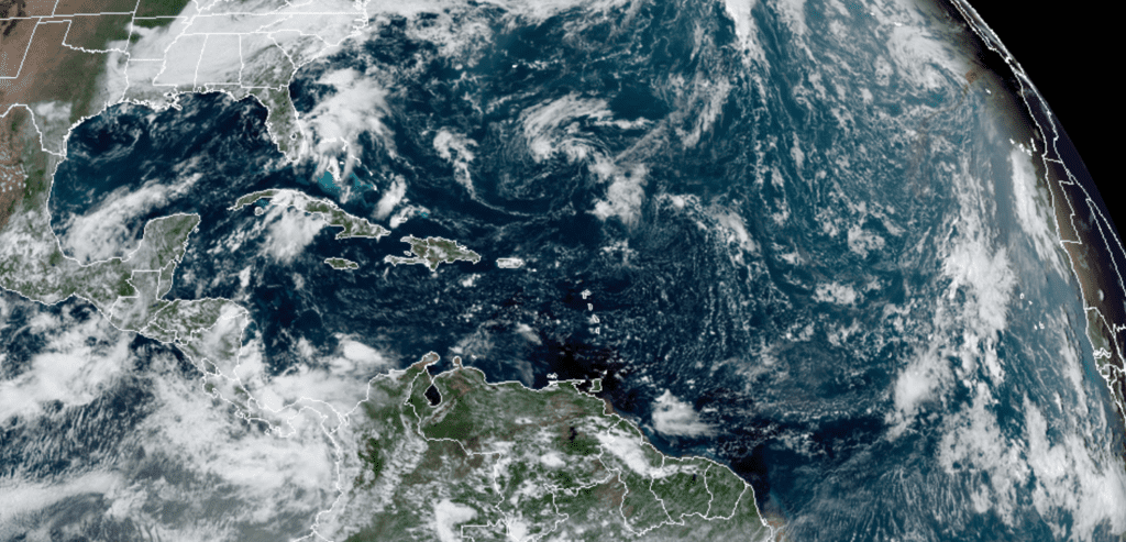
NOAA-RAMMB 09/25/2020 1:00 pm CDT
International Observe the Moon Night this Saturday
Get ready to admire our Moon! Saturday September 26th is International Observe the Moon Night. This event, which debuted in 2010, is very much the thrust of the Lunar Reconnaissance Orbiter and Lunar Crater Observation and Sensing Satellite mission teams. It’s also sponsored by other NASA institutes dedicated to increasing our understanding of and appreciation for the Moon. Their collective aim is to get people inspired by our closest cosmic neighbor, and to instill both a sense of awe in the Moon and a desire to learn more about its history and science.
Find out more and participate at https://moon.nasa.gov/observe-the-moon-night
On Saturday September 26th the Moon will be waxing gibbous, a couple of days past first quarter. Look for the planet Saturn very close to the moon Saturday night.
Have a good weekend.
Bob
Social Media