Sunny and very quiet weather conditions are in place across Texas on this Monday. The atmosphere is dry and quite stable thanks to a ridge of high pressure in the upper atmosphere covering the southwestern US and northern Mexico. At the surface, a weak cold front is pushing south out of North Texas. As of mid-afternoon, the front stretched from Longview to Austin, to Rocksprings. The front is forecast to quietly move south across Central Texas this afternoon, reaching the coastal plains this evening. No rain or clouds are forecast with the front. However, temperatures will trend slightly cooler tonight and Tuesday in its wake.
- Today’s temperature will warm to around 70 degrees across the Hill Country, reaching the low to mid-70s at most other locations.
- Lows Tuesday morning will include the mid and upper 30s across the Hill Country and Central Texas regions, with low to mid-40s towards the coast.
- High temperatures Tuesday will be in the mid-60s, and be close to 70 near the coast.
- Lows Wednesday morning will range from the low and mid-40s west to the low 50s towards the coast.
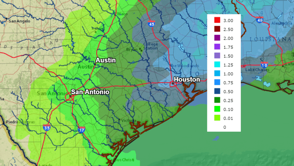
Tuesday’s weather will be mostly sunny. Southerly breezes will return Tuesday afternoon into Tuesday night ahead of a strong trough of low pressure pushing east out of the southern Rockies. Clouds and moisture look to spread north into Central Texas and the Hill Country Tuesday night in advance of the trough. A cold front connect to upper trough will push southeast across our region Wednesday afternoon into Wednesday evening. Forecasts call for a slight chance to a chance for rain showers and isolated thunderstorms to develop across the eastern Hill Country as well as Central Texas and the middle Texas coast beginning Wednesday morning, continuing through Wednesday afternoon as the front moves across the area. The rain should end from west to east late Wednesday afternoon. The most organized rain is predicted to occur over areas east of Interstate 35, where totals should average between a quarter and a half inch. For areas along and near I-35, totals should average around a quarter inch. Little to no rain is forecast across the western and central Hill Country.
NWS Rainfall forecast for the Period 6 pm Monday through 6 pm Thursday:
Sunny and cooler weather will follow the cold front Thursday and Friday. High temperatures Thursday will be around 60-62 degrees, trending down to the mid and upper 50s Friday. Lows Thursday morning range from the low and mid-30s Hill Country to the low 40s near the coast. Lows Friday morning will range from the low 30s across the Hill Country to the upper 30s near the coast.
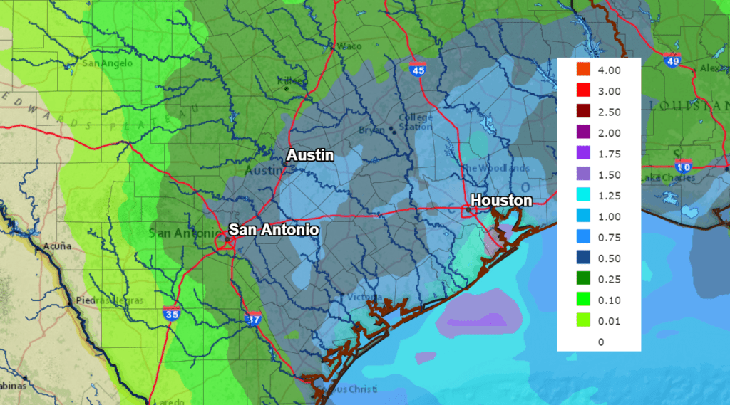
Forecasts call for another trough of low pressure to track southeast out of the southern Rockies Saturday, then move across the northern half of Texas on Sunday. With this system coming in further south compared to Wednesday’s system, forecasts show the potential for more widespread and somewhat heavier rains to develop across the region Saturday night into Sunday night. The chance for rain should diminish Sunday night. Forecasts call for totals of 0.25 to 0.5 inches across the Hill Country and totals between 0.5 and 1 inch for most other locations.
NWS Rainfall Forecast for the Period 6 pm Saturday through 6 pm Sunday:
Weekend temperatures will be cool, with highs in the low and mid-50s. Lows will be in the mid and upper 30s.
Looking out into the week of January 11th, long-range forecasts call for sunny, dry and cool weather for most of the week. There are some indications another storm system could move across the area late in the week. High temperatures will be in the upper 50s to low 60s while low temperatures will be in the 30s to low 40s.
Last Thursday’s Snow Still on the Ground Across Parts of West Texas
It’s hard to believe, but quite a bit of the snowpack received from last week`s storm system is still hanging around across parts of West Texas. The snow is still in place across portions of the eastern and southern Permian Basin, the Stockton Plateau, the higher terrain south of I-10, and portions of the Big Bend Area. According to surface observations, snow totals of 12-14 inches fell across Howard and Mitchell Counties, in the area around Big Spring and Colorado City last Thursday. The following visible satellite image from 12:20 pm Monday clearly shows the snow still in place across West Texas.
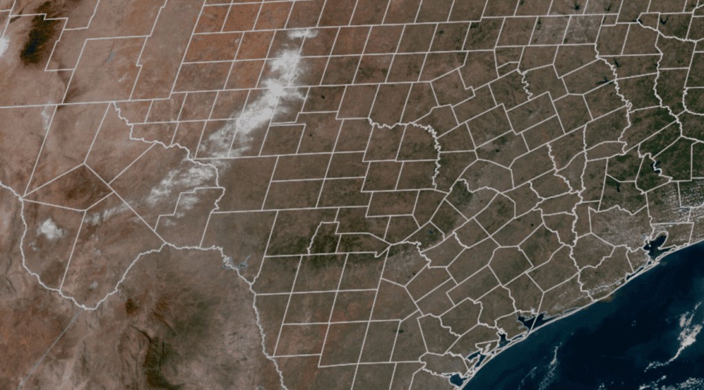
RAMMB-Colorado State University 01/04/21 2:50 pm CST
Bob
Social Media