A quiet weather pattern is in place across Texas on this All Hallows Eve. Early afternoon satellite images showed a large area of high clouds spreading east across Texas out of Mexico. These clouds are out ahead of our next weather maker—a small trough of low located over northern Mexico. The trough is forecast to track to the southeast and move across Central and South Texas tonight into Tuesday afternoon. The trough is already pulling moisture north from the Gulf of Mexico, resulting in a large overrunning low clouds across Deep South Texas and the Rio Grande Plains. High resolution forecasts call these clouds to spread north to cover Central Texas and the Hill Country regions late this afternoon and this evening. These same forecasts call for light rain showers and even a couple of isolated thunderstorms to develop across parts of the Hill Country and Central Texas beginning around midnight Monday night, continuing till about midday Tuesday. For the coastal region, light showers are predicted to begin after midnight Monday night, and continue through Tuesday afternoon.
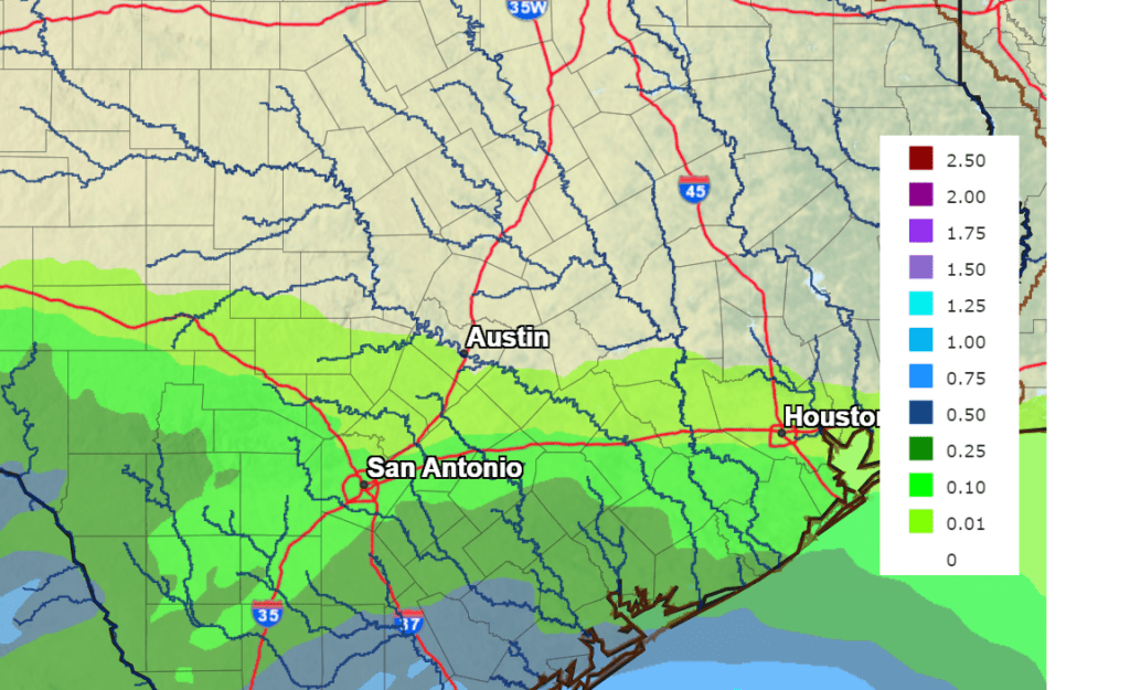
The highest probability for rain through Tuesday afternoon is forecast to be for areas generally along and south of Interstate 10, with lower probabilities to the north. Rain amounts are also forecast to be heaviest across coastal counties, where totals of 0.25 to 0.5 inches are forecast. Elsewhere, totals are predicted to average less than a quarter inch.
NWS Rainfall Forecast for the Period 7 pm Monday through 7 pm Wednesday:
All of the rain is predicted to exit the region by late Tuesday afternoon. Mostly sunny and dry weather will follow Wednesday and Thursday.
Temperatures will be mild Tuesday through Thursday. Highs in the mid-70s Tuesday, are forecast to warm to the upper 70s Wednesday, and the low 80s Thursday. Lows Wednesday morning will be in the low and mid-50s. Lows Thursday and Friday mornings are predicted to be in the mid and upper 60s.
The next change in the weather looks to take place late week through Saturday when a trough of low pressure pushes inland along the West Coast and tracks southeast to the Desert Southwest. Forecasts call for trough to lift northeast across northwestern and North Texas Friday night into Saturday. In advance of the approaching trough, forecasts call for moisture to return off the Gulf as early as Thursday evening and Thursday night, resulting in a slight chance for rain showers and isolated thunderstorms. There will be a 30-40 percent chance for showers and thunderstorms across the region on Friday. But the most favorable period for rain and thunderstorms will arrive Friday night and continue through Saturday as the upper low advances east Northwest Texas. Forecasts call for 50-60 percent chance for rain and thunderstorms across the region Friday night through Saturday with the best chance for rain occurring Saturday morning into afternoon when a Pacific cold front associated with the upper trough pushes east across the state. There are early indications some of the thunderstorms on Saturday may be strong to severe—producing large hail and damaging winds. The rain should taper off from west to east Saturday afternoon as drier and more stable air spreads in behind the cold front.
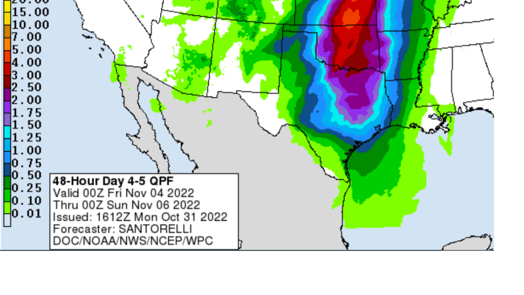
Rain amounts with the system late week are expected to be quite a bit higher, compared to the system on Tuesday. National Weather Service forecasts call for widespread totals of 0.5 to 1 inch across the Hill Country, and between 1 and 1.5 inches at most other locations.
NWS Rainfall Forecast for the Period 7 pm Thursday through 7 pm Saturday:
In the wake of Saturday’s rain and storms, sunny and dry weather will follow Sunday and all of next week. Just a minor cooldown is forecast for next week, with highs mainly in the mid and upper 70s, and lows mostly in the 50s.
Tropical Weather Outlook
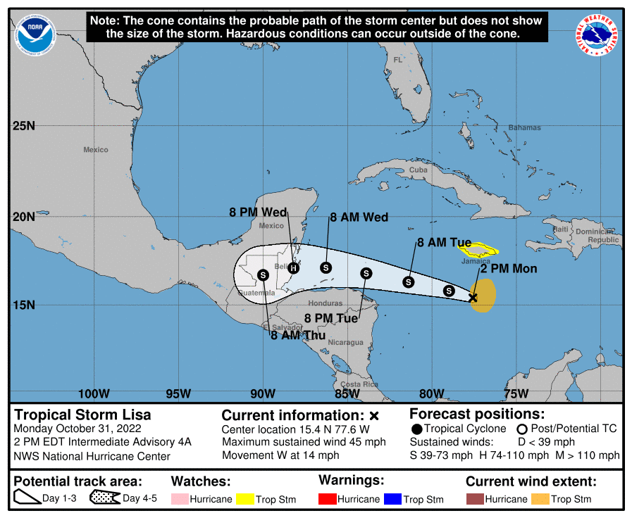
The strong tropical disturbance forecasters have been watching across the Caribbean Sea strengthened into Tropical Storm Lisa Monday morning. As of 1 pm CDT, the center of Tropical Storm Lisa was located about 185 miles southwest of Kingston, Jamaica. Lisa was moving toward the west near 14 mph, and a westward to west- northwestward motion is expected over the next few days. On the forecast track, the center will pass south of Jamaica today, south of the Cayman Islands Tuesday, and approach Central America on Wednesday. Lisa poses no threat to the western Gulf or the coast of Texas.
Data from an Air Force Reserve Hurricane Hunter aircraft indicated maximum sustained winds have increased to near 45 mph with higher gusts. Slow strengthening is forecast during the next few days, and Lisa could become a hurricane over the northwestern Caribbean Sea.
Time Change Weekend
Daylight Saving Time will come to an end this coming Sunday, November 6th, at 2:00 am. At that time, we will “fall back”, turning our clocks back one hour. Going forward, the evenings will get dark much sooner, but it will get light earlier in the mornings.
Bob
Social Media