It final started to feel like December this past weekend. The cold front early Saturday ushered in some of the coldest temperatures so far this autumn. The temperature fell well below freezing early Sunday morning across the Hill Country and much of Central Texas experienced its first freeze of the season. According to LCRA’s Hydromet, lows Sunday morning were generally in the low and mid-20s across the Hill Country, in the mid-20s to low 30s across Central Texas and in the upper 30s to low 40s across the coastal plains. Several spots across the western and northern Hill Country reported lows in the upper teens. In Austin, Sunday morning’s low temperature at Camp Mabry was 33 degrees. The low temperature at Austin-Bergstrom was 26 degrees.
As we have seen so often this autumn, this weekend’s cold air didn’t stick around for very long. Warm, southerly breezes off the Gulf of Mexico developed late Sunday and strengthened Sunday night into Monday morning. Temperatures early Monday weren’t quite as cold, with very few freezing temperatures recorded across the Hill Country.
Get ready for a mild, mostly cloudy and humid week. This afternoon, warm southerly winds flowing through and over the cool air at the surface have resulted in the development of widespread lower-level clouds over much of southern, central and eastern Texas. These clouds are forecast to remain in place this afternoon and tonight, continuing through Tuesday morning. Interestingly, early this afternoon, Doppler radar showed a few spotty light rain showers occurring across the coastal plains region where moisture return has been the greatest. Additional spotty light showers look to continue off and on across the coastal plains region this afternoon and tonight. For the rest of the region, expect an overcast sky and warmer temperatures this afternoon, with highs around 70 degrees. The western and northern Hill Country should see temperatures in the mid-70s with scattered sunshine.
This evening and overnight, clouds will persist across the region. Dense fog is predicted to develop across much of the region around midnight and continue into Tuesday morning. In addition, patchy drizzle and spotty light showers will be possible after midnight. Lows Tuesday morning will range from the mid-50s across the Hill Country to the mid-60s across the coastal plains.
On Tuesday, widespread clouds and fog are forecast through late morning. However, the clouds and fog are predicted to lift early Tuesday afternoon, resulting in a partly cloudy sky. It will be warm and humid, with a high temperatures around 78-80 degrees. Expect southerly breezes to increase to a range of 10-15 mph, with gusts to 25 mph. The sky is forecast to become cloudy Tuesday night. Lows Wednesday morning will range from the low 60s across the Hill Country to the upper 60s near the coast.
Wednesday into Thursday morning’s weather is are shaping up to be similar to Tuesday. Morning clouds will give way to partly cloudy, breezy and warm conditions in the afternoon. The high temperature Wednesday is forecast to be near 80-82 degrees. Expect a breezy south wind at 10-20 mph with gusts to 30 mph. Lows Thursday morning will be in the upper 60s.
Thursday sky is forecast to expected to remain mostly cloudy to overcast. A weak cold front is forecast to sink south out of North Texas and stall across Central Texas in the afternoon. The boundary may provide the focus for the development of a few scattered rain showers across the region. The probability for rain at any given location will only be 20 percent. Ran amounts, if any, will total less than a tenth of an inch. Despite the front, warm temperatures will continue with highs ranging from the mid-70s north, to the low 80s towards the coast. Lows Friday morning will generally be in the mid-60s.
Friday’s weather will feature morning clouds and a partly cloudy afternoon. Expect a high temperature near 78-80 degrees.
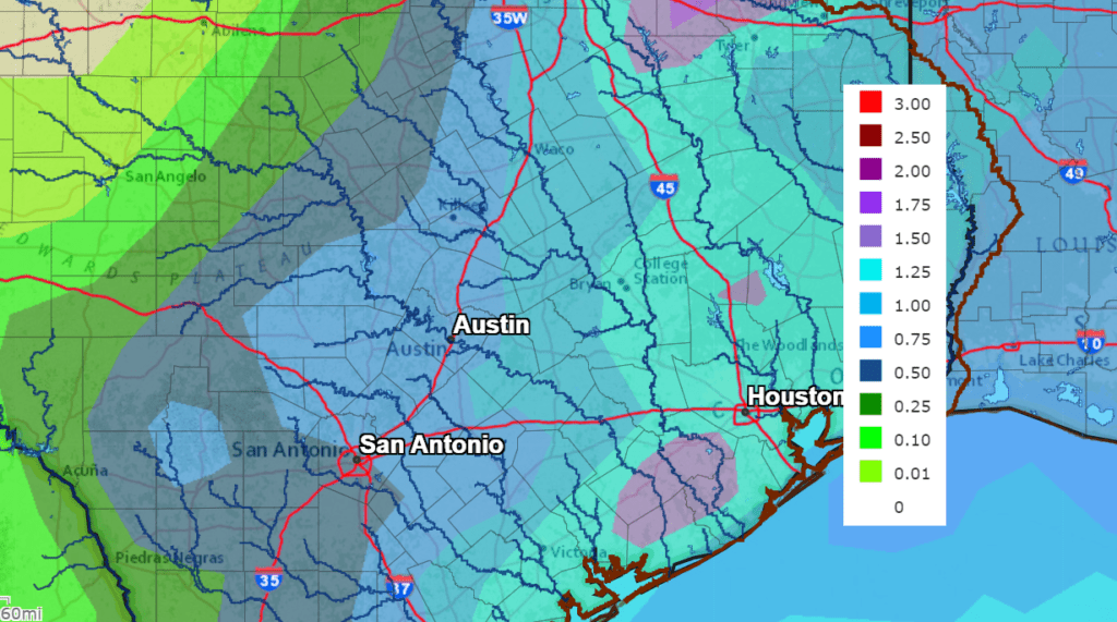
Big changes in the weather are forecast to take place this weekend. The changes will start late Friday night into Saturday morning when a strong cold front pushes south across the region. The front should move off the coast around midday Saturday. Scattered rain showers and a few thunderstorms are forecast along and behind the cold front beginning late Friday night, continuing through Sunday. Weak waves of low pressure tracking east out of Mexico over the weekend are expected to produce widespread overrunning clouds with periods of light to moderate rain. The threat for severe storms over the weekend appears to be extremely low. Rainfall from the weekend rain showers and thunderstorms is forecast to average between 0.5 and 1 inch across the Hill Country and between 1 and 1.5 inches for areas along and east of Interstate 35.
NWS Rainfall Forecast for the Period 6 pm Monday through 6 pm Next Monday:
Weekend temperatures will be noticeably cooler, with high temperatures in the low and mid-50s. Low temperatures Sunday and Monday mornings will include the mid and upper 30s across the Hill Country and Central Texas, with mid-40s near the coast.
The outlook for next week calls for mostly sunny, dry and mild weather through Christmas Eve. Cool temperatures Monday will give way to high temperatures in the 70s Tuesday through Friday. Lows temperatures are forecast to be in the upper 50s to low 60s. Not exactly Christmas type temperatures.
The Geminid Meteor Shower is Underway
Earth has entered a stream of debris from rock comet 3200 Phaethon, source of the annual Geminid meteor shower. Last night, Dec. 12-13, NASA cameras recorded 46 Geminid fireballs over the USA. Many more are coming. Forecasters expect the shower to peak the morning of Dec. 13-14 with as many as 100 meteors/hour visible from dark sky sites. Unfortunately, for Central Texas, it looks like we won’t be able to see the show due to widespread clouds.
If you plan to drive west in search of a clear sky, here is a link to some observing tips: https://www.imo.net/viewing-the-geminid-meteor-shower-in-2021
Have a good week.
Bob
Social Media