The cloudy and cool weather pattern we saw over the weekend has given way to unseasonably warmer weather as a moderate wind flow has developed off the Gulf of Mexico. However, the generally cloudy pattern we’ve been seeing lately is not expected to change significantly.
A warm front lifted north through Central Texas and the Hill Country Sunday night, taking the cool air with it. Warm and humid Gulf air has replaced the cool air, making it feel more like early fall. South and southwesterly breezes have developed in response to an area of low pressure developing across the southern Plains. Wind speeds of 10-15 mph, with occasionally gusts to 25 mph can be expected through Monday night. Some scattered sunshine will develop this afternoon, but a mostly cloudy to overcast sky looks to return by midnight Monday night.
- Monday’s temperature is forecast to warm to the mid and upper 70s. Lows Tuesday morning will range from around 60 degrees across the Hill Country, to the upper 60s near the coast.
Tuesday and Wednesday’s weather is shaping up to be similar to Monday’s. Widespread clouds and patchy fog are forecast late night and into the morning. The clouds should give way to a partly to mostly cloudy sky in the afternoon. Breezy conditions will continue, weather, with southerly winds around 10-15 mph.
- High temperatures both days are predicted to be in the upper 70s to low 80s. Lows Wednesday and Thursday mornings will range from the low 60s west, to the upper 60s near the coast.
A mostly to overcast cloudy sky is forecast across the region Thursday as considerable moisture spreads in out of the Pacific. There will be a slight chance for a few scattered, light rain showers for areas along and east of Interstate 35 Thursday through Thursday night. Rain amounts, if any, should only total a few hundredths of an inch.
- High temperatures Thursday are forecast to in the around 78-80 degrees. The low Friday morning will include the mid-50s across the Hill Country, the upper 50s across Central Texas, and the low 60s near the coast.
A weak cold front is predicted to sink south across the area Thursday night into early Friday morning, bringing with it some slightly cooler air. No rain is expected with the front. Expect a partly to mostly cloudy sky Friday.
- High temperatures Friday will range from the mid-60s across the Hill Country, to the mid-70s towards the coast. Lows Saturday morning will be in the mid and upper 50s.
For the upcoming weekend, expect a 20-30 percent chance for rain showers across the region Saturday through Sunday morning as a trough of low pressure begins to sink southeast out of the southern Rockies. Rain amounts are predicted to be low—generally around a tenth of an inch or less both days. The sky is shaping up to be mostly cloudy Saturday and partly cloudy Sunday afternoon. Forecasts call for another weak cold front to push across our are late Saturday into Sunday.
- High temperatures Saturday are forecast to be in the low and mid-70s. Highs will cool to upper 60s on Sunday.
Next week’s weather is forecast to start off mild, but trend noticeably cooler beginning Monday night as a fairly strong cold front moves across the area. Generally dry but cool weather is predicted behind the cold front Tuesday through Friday .
- High temperatures Monday are predicted to be in the mid and upper 60s.
- High temperatures Tuesday through Friday are predicted to be in the 50s.
- Low temperatures Tuesday through Friday mornings are predicted to generally be in the 40s.
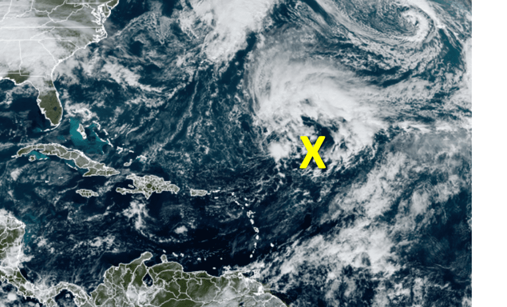
Forecasters Monitoring Possible Tropical Development in the Subtropical Atlantic
Although the hurricane season officially ended last Thursday, the tropics may not be quite done yet. National Hurricane Center forecasters indicate a large area of low pressure has developed over the central subtropical Atlantic, about 750 miles northeast of the northern Leeward Islands. This low pressure system is producing disorganized showers and thunderstorms. Environmental conditions appear conducive for this system to acquire some subtropical characteristics while it drifts northeastward during the next few days. By Thursday night or Friday, however, the low is expected to move over cooler waters, ending its chances of becoming a subtropical cyclone. NHC forecasters are giving this system a 40 percent chance for development over the next 5 days.
Have a good week.
Bob
Social Media