The heart of the hurricane season is just around the corner and according to a leading hurricane expert, we haven’t seen anything yet. On Wednesday, meteorologist Phil Klotzbach and his forecast team at Colorado State University released an updated prediction for this year’s Atlantic hurricane season.
“We have increased our forecast and now call for an extremely active 2020 Atlantic hurricane season,” Klotzbach said.
In all, Klotzbach and his team predict a total of 24 named storms in 2020. This includes the nine named storms that have already formed: Arthur, Bertha, Cristobal, Dolly, Edouard, Fay, Gonzalo, Hanna and Isaias. Of those, the team expects 12 to become hurricanes (including the two hurricanes that have already formed, Hanna and Isaias). The team predicts 2020 hurricane activity will be about 190% of average according to the new forecast. By comparison, 2019’s hurricane activity was about 120% of average and it was classified as a hyperactive season.
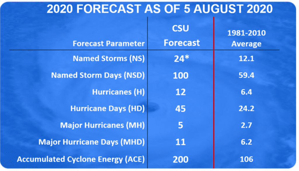
Twelve hurricanes is the most the forecast team has ever predicted in its August forecast. This updated outlook is an increase from the early July seasonal forecast which predicted 20 named storms, nine hurricanes and four major hurricanes.
Klotzbach stated there are three main reasons for his “extremely active” forecast. First, sea surface temperatures averaged across the tropical Atlantic are much warmer than normal and warmer waters mean more fuel for storms.
Another reason for the very active seasonal forecast are observations showing vertical wind shear across the Atlantic is well below average. Having less shear generally aids in tropical storm development and intensification.
Finally, neutral ENSO conditions currently in place across the Pacific may transition to weak La Niña conditions by later this summer. According to Klotzbach, La Niñas often increase hurricane numbers in the Atlantic.
Klotzbach’s updated outlook also stated an above-normal probability for major hurricanes making landfall along the continental United States coastline and in the Caribbean.
NOAA and the National Hurricane Center will release their updated outlook for the hurricane season Thursday.
Observations Wednesday afternoon showed weather conditions were generally quiet across the tropical Atlantic, the Caribbean Sea and the Gulf of Mexico. NHC forecasters are watching a small but well-defined low pressure system located a few hundred miles southwest of Bermuda. This system is producing an area of disorganized showers and a few thunderstorms. Although the low has remained nearly stationary today, NHC forecasters call for the low to drift west-southwestward during the next couple of days. Any development of this disturbance should be slow to occur due to dry air and increasing upper-level winds by the weekend. NHC forecasters giving this system just a ten percent chance for development over the next five days.
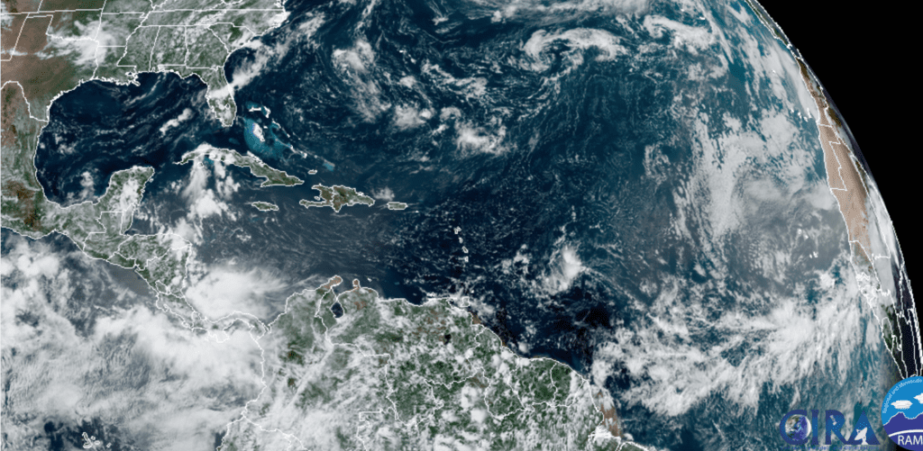
RAMMB-CIRA 08/05/2020 1:10 pm CDT
Bob
Social Media