A period of wet weather is still in the forecast for Friday and this weekend as a large trough of low pressure sinks into the Desert Southwest and then slowly lifts up to the northeast. Forecasts call for rain showers and thunderstorms to increase in coverage across our region late Thursday night into Friday morning in advance of a cold front pushing south out of the Texas Panhandle. The front is forecast to sweep across the area Friday and pull up stationary near the middle Texas coast Friday evening. Some strong thunderstorms will be possible along the frontal boundary. Widespread rain showers and isolated thunderstorms are predicted Friday night, Saturday and Saturday night as an overrunning pattern sets up behind the front. The chance for rain is predicted to end from west to east Sunday morning.
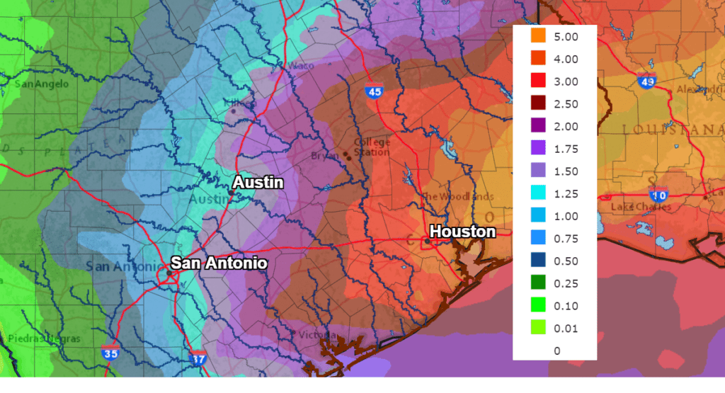
Tuesday’s forecast data calls for a widespread area of rain developing Friday through Sunday, with the heaviest rains developing over Southeast Texas. National Weather Service rainfall forecasts call for 3-day totals across the Hill Country of 0.5-1 inch. Across Central Texas, totals should average between 1 and 2 inches. Meanwhile across the middle Texas coast, totals are forecast to average between 2 and 3 inches. Isolated heavier totals will be possible.
NWS Rainfall Forecast for the Period 6 pm Tuesday through 6 pm Next Tuesday:
A reinforcing cold front is forecast to sweep across the area Sunday, bringing much colder air for Sunday night and early next week. Some of the coldest temperatures so far this season are forecast for Monday night, with a light freeze possible across the Hill Country and most of Central Texas, including the Austin area.
- Lows Sunday night will include the low and mid-30s Hill Country, the upper 30s across Central Texas and the lower 40s towards the coast.
- High temperatures Monday will be in the upper 50s.
- Lows Tuesday morning will include the upper 20s across the Hill Country, the low 30s across Central Texas and the mid-30s across the coastal plains.
- High temperatures Tuesday will again be in the upper 50s.
- Lows Tuesday night will generally be in the mid and upper 30s.
I’ll have another update on these weather changes Wednesday.
Bob
Social Media