It’s early August and we’ve reached what is typically the hottest point of summer. It’s at this time when the jet stream lifts far up to the north, causing most weather systems to slow way down. Ridges of high pressure cover much of the southern U.S., causing a persistent pattern of hot and generally dry weather.
True to form, Friday’s weather maps showed a broad area of high pressure in the middle and upper atmosphere covering the southern U.S., with the ridge being centered over West Texas, just east of Midland. Fortunately, this ridge is not quite as strong as the ridge that was in place during in the first half of July. As a result, we’re not seeing the temperatures quite as hot as they were in July. Sinking air under the ridge is causing a very stable and dry atmosphere. Weather conditions are sunny, hot and dry.
Forecasts call for the ridge to continue to be our region’s dominant weather feature this weekend, and through all of next week. The center of the ridge is predicted to remain over West Texas through the middle of the week, then shift west to northern Mexico and southern New Mexico late next week into next weekend.
With the ridge in place, sunny, dry and hot weather conditions will persist across the Hill Country and Central Texas regions through late next week. In addition, daily high and low temperatures are expected to remain quite consistent. High temperatures this afternoon through next Friday across the Hill Country and Central Texas regions are predicted to be near 100-103 degrees. Across the coastal plains, daily high temperatures will be in the mid-90s.
Across the coastal plains region, an isolated rain shower or two will be possible each afternoon through early next week where the strength of the ridge won’t be quite as strong. Forecasts call for a slight increase in the chance for scattered showers and isolated thunderstorms Wednesday through Friday as the ridge’s influence weakens further. Rain amounts through late next week are forecast to be low—generally under a quarter inch.
The center of the high pressure ridge is forecast to shift west to the Four Corners region next weekend and continue over that location through the week of August 17th. With the center of the ridge further to the west, the ridge’s grip on Texas is predicted to be weaker. Forecasts call for the development of widely scattered afternoon rain showers and isolated thunderstorms across the coastal plains region, with the activity also extending inland to the Austin/Interstate 35 corridor throughout the week of August 17th. With the tropical moisture spreading inland from the Gulf, spotty totals of around quarter inch are forecast across Central Texas. Totals between a quarter and a half inch are forecast across the coastal plains region.
With the ridge losing some of its grip, high temperatures are forecast to lower slightly beginning next weekend, continuing through the week of the 17th. High temperatures across the Hill Country and Central Texas regions are predicted to generally be near 97-100 degrees. Across the coastal plains, high temperatures are predicted to be in the low and mid-90s.
No significant change in the temperature or rainfall pattern is predicted through the fourth week of August.
Tropical Weather Outlook
Weather conditions are fairly quiet across the tropical Atlantic, the Caribbean Sea and the Gulf of Mexico.
However, National Hurricane Center forecasters are monitoring a tropical wave located in the eastern tropical Atlantic, several hundred miles west-southwest of the Cabo Verde Islands. This system is currently accompanied by minimal shower activity. Slow development of this system is possible during the next couple of days as it moves slowly westward. After that time, environmental conditions are expected to become less conducive for development. NHC forecasters only give this system a 10 percent chance for development over the next 5 days.
Elsewhere, there are no systems in place which pose a threat for development over the next 5 days.
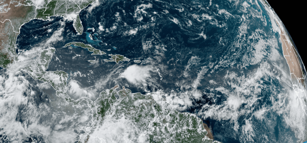
RAMMB-CIRA 08/07/20 1:00 pm CDT
The Perseid Meteor Shower
The Perseid meteor is typically one of the two best displays of “shooting stars” all year. The meteors are caused when little bits of grit, shed by a comet called Swift-Tuttle, slam into our atmosphere at 37 miles per second. Every August, like clockwork, we cross the comet’s orbit and plow right through this dusty debris. The good thing is you don’t need any special equipment to enjoy the Perseids, so this annual sky show makes a wonderful activity for the whole family.
The Perseid meteor shower should be at its strongest Tuesday night, August 11th. This year, however, the Moon rises around midnight, and its light will likely interfere somewhat during the prime meteor hours, from midnight to dawn. So you might do best watching before then, from about 11 pm through moonrise.
The best direction to look is wherever your sky is darkest, usually overhead. The shower’s radiant (the meteors’ perspective point of origin, if you could see them coming from far away in space) is in northern Perseus under Cassiopeia. But the meteors only become visible when they hit the upper atmosphere, anywhere in your sky.
While the meteor shower will peak on the night of August 11th, you may see the occasional Perseid on any night this weekend or next week. With a mostly clear sky expected this weekend, give it a shot. For more information, check out Spaceweather.com
Have a good weekend.
Bob
Social Media