The Fourth of July weekend was for the most part quiet and very hot. Some isolated rain showers and thunderstorms developed across parts of the region Saturday. The most notable totals occurred across the western Hill Country, in the area between Junction and Sonora, where three LCRA gauges recorded totals between 1 and 1.25 inches. Elsewhere, there were a few spotty totals of less than a quarter inch, with most locations staying dry.
A dry, quiet, and very hot weather pattern looks to be in store for Central and South Texas this week. Tuesday’s weather maps showed a broad, stable ridge of high pressure in the upper atmosphere, or heat dome, covering the central and southern U.S. The ridge is currently centered over Northeast Texas. This week, the center of the ridge is forecast to slowly shift to the west-northwest, arriving over the Four Corners area early next week.
Ridging over our region this week will result in sunny, dry, and very hot weather conditions. High temperatures are predicted to rise about 2-4 degrees late week and through the weekend as the center of the ridge spreads across northern Texas. Temperatures are predicted to reach their peak on Sunday and Monday. Expect a moderate southerly breeze throughout the week, with wind speeds generally in the range of 5-12 mph with occasional gusts to 20 mph.
- High temperatures this afternoon through Thursday are forecast to be around 100-103 degrees across the Hill Country and Central Texas regions, and in the upper 90s across the coastal plains.
- High temperatures Friday through Monday are forecast to be near 102-105 degrees across the Hill Country and Central Texas regions, and around 100-102 degrees across the coastal plains.
This is going to be a very hot week and weekend. The National Weather Service is advising everyone to drink plenty of fluids, stay in an air-conditioned room, stay out of the sun as much as possible, and check up on relatives and neighbors. Young children and pets should never be left unattended in vehicles under any circumstances! Take extra precautions if you work or spend time outside. When possible, reschedule strenuous activities to the early morning or evening.
Looking ahead to next week, no significant change in the pattern is forecast Monday through Thursday. Forecasts call for continued sunny and very hot weather across the region. Expect high temperatures to be in the range of 100-103 degrees across the Hill Country and Central Texas regions, and in the upper 90s across the coastal plains.
Long-range forecasts do indicate some changes in the pattern may take place late next week into the following weekend as the upper ridge shifts further to the west,, allowing a trough of low pressure to develop south through the Ohio and Tennessee Valleys. This trough will help push a weak cold front south into Texas sometime around next Friday or Saturday, possibly leading to the development of scattered rain showers and thunderstorms. Slightly lower temperatures are forecast to develop, with highs dropping to the mid and upper 90s for a three to four day period.
Unfortunately, this looks to be just a very temporary break in the ongoing very hot and dry summer pattern.
Tropical Weather Outlook
After a fairly active week last week, conditions have become quiet across the tropical Atlantic, the Caribbean Sea and the Gulf of Mexico. These quiet conditions are forecast to persist into the upcoming weekend. There are no systems in place which pose a threat for tropical development over the next 5 days.
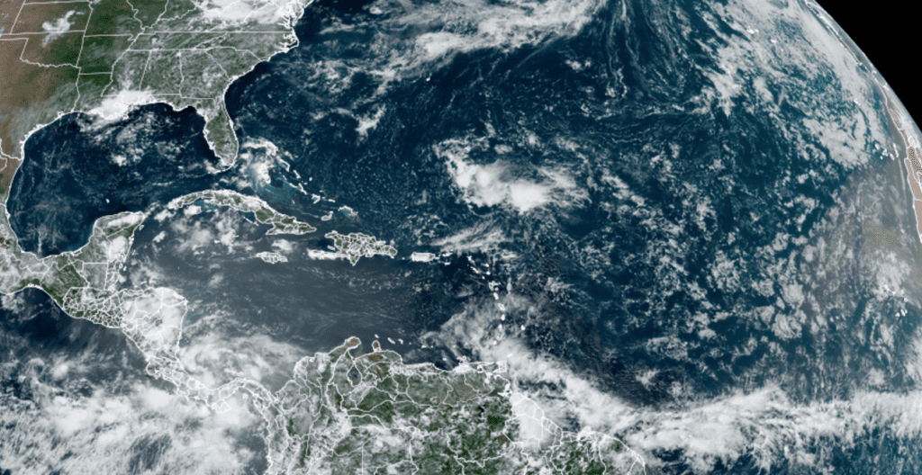
NOAA/Colorado State University/RAMMB 07/05/2022 12:40 pm CDT
The “Dog Days” of Summer Have Officially Begun
The “Dog Days” of summer are from July 3 to August 11 each year. They’re usually the hottest and most unbearable days of the season. We often hear about the “Dog Days” of summer, but few know where the expression originated. Some think it’s a reference to the hot, sultry days that are “not fit for a dog.” Others suggest it’s the time of year when the extreme heat drives dogs mad.
The phrase is a reference to Sirius, the Dog Star. During the “Dog Days” period, the Sun occupies the same region of the sky as Sirius, the brightest star visible from any part of Earth. Sirius is a part of the constellation Canis Major, the Greater Dog. In the summer, Sirius rises and sets with the Sun. On July 23rd, specifically, it is in conjunction with the Sun, and because the star is so bright, the ancient Romans believed it actually gave off heat and added to the Sun’s warmth, accounting for the long stretch of sultry weather. They referred to this time as diēs caniculārēs, or “dog days.”
Thus, the term Dog Days of Summer came to mean the 20 days before and 20 days after this alignment of Sirius with the Sun—July 3 to August 11 each year.
Widely used in northern Mexico and among Spanish-speaking Texans, “La Canícula” also refers to the dog days of summer: a forty-day period in July and August characterized by rainless, hot, and stagnant days.
Bob
Social Media