An August-like weather pattern across Texas this week has been responsible for widespread triple-digit temperatures at most locations. Unfortunately, few changes are expected as we head into the weekend. Friday’s weather maps showed a broad and strong ridge of high pressure in the middle and upper atmosphere covering the southern U.S. and northern Mexico, with the ridge being centered over west-central Texas. Forecasts call for the ridge to remain across Texas through Sunday, followed by weakening and a slow shift to the west early next week.
This afternoon through Sunday, expect continued sunny, dry and very hot weather across the entire region. There will be a south-southwesterly breeze of 10-15 mph each day.
- High temperatures Friday through Sunday are forecast to be around 100-104 degrees across the Hill Country and Central Texas regions, and be near 98-101 degrees across the coastal plains.
Changes to the ongoing weather pattern are forecast to take place beginning Monday, when a strong trough of low pressure tracking east across the northern Plains causes the ridge over Texas to weaken, pushing the center of the ridge to the Desert Southwest. All of this will allow a weak cold front to sink south across Texas. Forecasts call for the cold front to reach northern Texas Sunday evening into Sunday night, and the Central Texas region sometime Monday afternoon into Monday night. The front is predicted to stall somewhere near the middle Texas coast late Monday night into Tuesday morning and remain over the general area through about next Thursday.
One additional feature to note influencing our weather mainly for areas along and east of Interstate 35 will be a small, non-tropical area of low pressure over the Gulf of Mexico. This system is forecast to push inland along the middle and upper Texas coast Monday afternoon into Tuesday. This low is expected to push an enhanced area of tropical moisture inland to about the Interstate 35 corridor Tuesday into Wednesday.
The combination of the advancing cold front, a much weaker ridge overhead, and increasing moisture off the Gulf will cause a chance for scattered rain showers and thunderstorms beginning Monday afternoon, continuing through Tuesday night. A slight chance for a few showers will linger into Wednesday. The most favorable area for rain next week is forecast to be across the coastal plains region, where the probability for rain will be at 40 percent. The probability for rain is forecast to be near 30-40 percent across Central Texas, and 20-30 percent across the Hill Country.
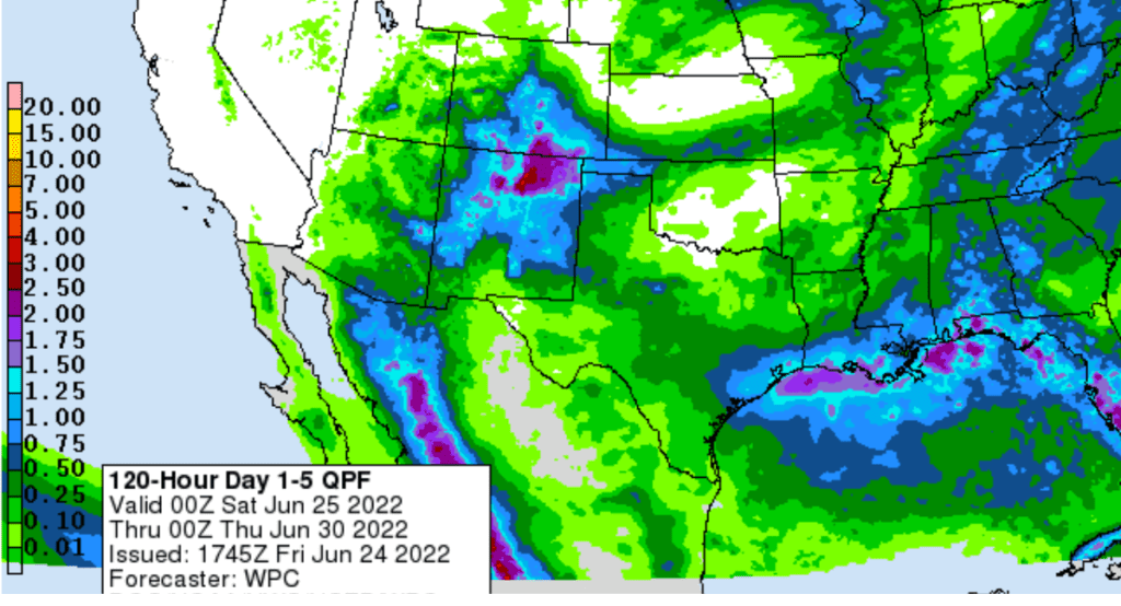
Unfortunately, a widespread or heavy rain is not expected, but a few isolated locations could see some a couple of good downpours. Expect a partly cloudy sky Monday through Wednesday. According to the National Weather Service, rain amounts are forecast to generally average between a quarter and a half inch across the Hill Country and the Interstate 35 corridor. For areas east of I-35, totals of 0.5 to 1.25 inches are forecast.
NWS Rainfall Forecast for the Period 7 pm Friday through 7 pm Wednesday:
Less hot temperatures are forecast for the first half of next week due to the weakened ridge and scattered rains. High temperatures Monday through Wednesday are forecast to generally be in the low and mid-90s across the region.
A mostly sunny, dry and hot pattern is forecast to return next Thursday as the ridge begins to reestablish itself across the south central and southeastern U.S. Long-range forecasts call for the ridge to hold over the area next weekend, continuing through the first week of July.
- High temperatures are predicted to be in the upper 90s next Thursday and Friday.
- High temperatures next weekend and the week of July 4th are forecast to be near 100-102 degrees.
Tropical Weather Outlook
Weather conditions are currently quiet across the Gulf of Mexico and the Caribbean Sea. Tropical cyclone development is not expected here over the next 5 days.
National Hurricane Center forecasters are closely monitoring a large area of disorganized showers and thunderstorms associated with a strong tropical wave located over the eastern tropical Atlantic. Environmental conditions appear conducive for development of this system over the next few days, and a tropical depression could form during the early to middle part of next week. The system is forecast to move westward at around 15 mph over the tropical Atlantic, approaching the Windward Islands around the middle of next week.
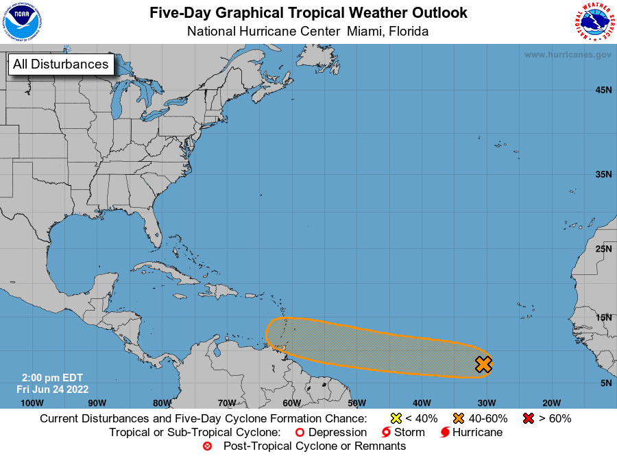
NHC forecasters are giving this system a 60 percent chance for tropical development over the next five days.
It’s too early to get a good handle on whether this system could eventually/potentially affect the Gulf of Mexico.
The Five-Planet Lineup Continues at Dawn
All five naked-eye planets remain lined up in the dawn sky for most of this week, about 45 minutes to an hour before sunrise. From Mercury through Saturn, they run from low in the east-northeastern sky, to high in the southern sky as dawn brightens. In the early dawn of Saturday June 25th, the waning crescent Moon will form a diagonal line with Venus and low Mercury. Mars, Jupiter, and Saturn are spread in a long line far to the upper right of this gathering. The planet Mercury will be leaving the special grouping late next week.
Bob
Social Media