We’ve seen a wet weather pattern for much of this week thanks to an unusual, stalled August cold front and a couple of disturbances moving northeast out of Mexico. While more scattered showers and isolated thunderstorms can be expected Friday afternoon and evening, a drier and more August-like weather pattern is forecast to begin taking hold Saturday as the front washes out and a flat ridge of high pressure starts to spread over Texas out of the western U.S.
For the weekend, expect a mostly sunny sky and warm temperatures. Weather conditions should be generally dry across the Hill Country and Central Texas regions. Across the coastal plains, moisture spreading north from the Gulf will cause a slight chance (20 to 30 percent chance) for a few scattered afternoon showers. Daily rain amounts should total less than a quarter inch.
- High temperatures both days are forecast to be in the mid-90s, with lower 90s towards the coast.
The outlook for next week calls for few changes as a flat ridge of high pressure continues across Texas and much of the southern U.S. Sunny, dry and hot weather is forecast. However, a slight chance for scattered afternoon showers will continue across the coastal plains as plumes of tropical moisture spread inland. Daily rain amounts should total less than a quarter inch.
- High temperatures next week are forecast to be in the mid and upper 90s across the Hill Country and Central Texas regions and in the lower 90s across the coastal plains.
Longer range forecasts looking out into next weekend and the week of August 16th indicate the chance for rain may increase some as the ridge of high pressure weakens and trough of low pressure develops south into the Ohio Valley. High temperatures are predicted to remain mostly in the mid to upper 90s.
Tropical Weather Outlook
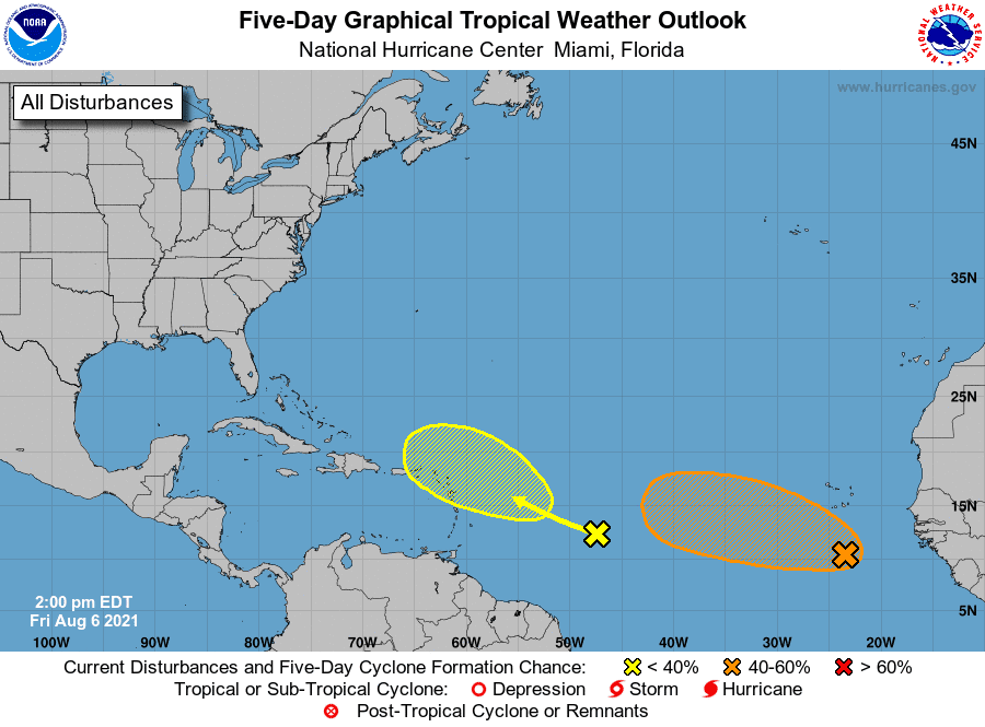
Two tropical systems over the central and eastern Atlantic are being closely monitored by National Hurricane Center meteorologists for the potential to develop into named storms. Fortunately, both systems are located well out into the Atlantic and don’t pose any concern for interests across the Gulf of Mexico at this time.
In the far eastern Atlantic, forecasters are monitoring a large area of disorganized cloudiness and showers associated with a tropical wave and a weak area of low pressure. This system is located a few hundred miles south of the Cabo Verde Islands. According to the National Hurricane Center, environmental conditions appear somewhat conducive for gradual development over the next several days, and a tropical depression could form late this weekend or early next week while the system moves generally west-northwestward across the tropical Atlantic. NHC forecasters are giving this system a medium chance (60 percent chance) for tropical development over the next 5 days.
NHC forecasters are also monitoring a tropical wave located over the west-central tropical Atlantic. This system is producing limited shower activity. Development, if any, of this system is expected to be slow to occur as it moves west-northwestward and approaches the Lesser Antilles early next week.
NHC forecasters are giving this system just a slight chance (a 20 percent chance) for development over the next 5 days.
Elsewhere, conditions are quiet and tropical storm development is not expected over the next 5 days.
Have a good weekend.
Bob
Social Media