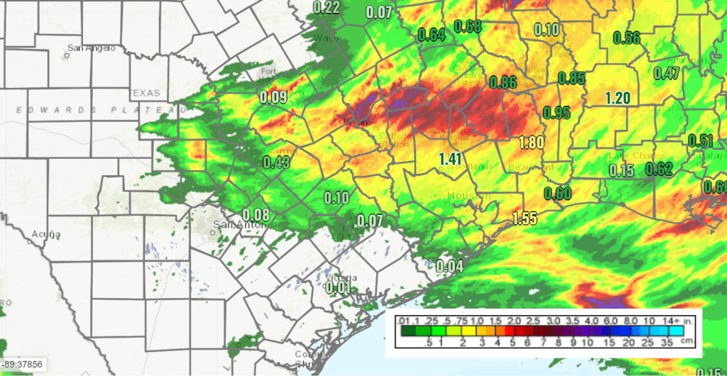
A weak cold front pushing south out of North Texas brought rain showers, scattered thunderstorms, and even some hail to parts of the region Thursday afternoon and Thursday night. LCRA’s Hydromet showed the highest totals of 1.5-1.7 inches occurred over an area just north of Lake Buchanan. Elsewhere, most totals averaged between a quarter and a half inch. A large part of the Hill Country and the middle Texas coast saw little to no rain.
The trough of low pressure and cold front responsible Thursday’s rain have exited to the northeast, taking the chance for additional rain with them. In place of the trough, a ridge of high pressure in the middle and upper atmosphere located over central and northern Mexico is quickly spreading northeast across Texas. This ridge is very similar to the kind what we see over Texas in the summer months, not in early May. As a result, our weather is expected to begin feeling very much like the middle of summer starting this weekend. And with the ridge forecast to remain over our area all of next week and into next weekend, this is going to be an extended period of generally dry and hot summer-like weather.
For Friday afternoon, expect a mostly sunny sky with high temperatures in the low and middle 90s. Winds are forecast to fairly light, mainly in the range of 5-10 mph.
Saturday through Sunday, the heat will be on as the ridge of high pressure strengthens, drawing very warm air northeast out of central Mexico.
- High temperatures are forecast to be near 100-102 degrees across the western and central Hill Country, in the upper 90s across Central Texas, and the mid-90s across the middle Texas coast.
Keep in mind, the air will be humid this weekend, which will cause the heat index to peak at around 105/106 degrees. Southerly breezes are forecast to increase to a range of 10-15 mph, with gusts to 25 mph both days. This should provide at least a little relief from the extreme heat.
The outlook for next week calls for little change as the summer-like pattern remains in place. For the eastern Hill Country, Central Texas, and coastal regions, no rain is forecast throughout the week and into next weekend. For the western and northern Hill Country regions, forecasts indicate there will be a slight chance for thunderstorms Monday and Tuesday evenings. A weak trough of low pressure tracking northeast on the backside of the upper ridge is forecast to cause the development of scattered thunderstorms along the West Texas dry line between the Concho Valley and the Rio Grande Plains. Some of these storms could track east to parts of the western Hill Country both evenings. A very stable atmosphere across Central Texas will limit the storms making it any further to the east. Rain amounts are forecast to remain under a quarter inch.
For most of the region, next week’s weather will feature a mostly sunny sky and hot temperatures. Fortunately, the breezy southerly winds look to continue.
- High temperatures Monday through Friday are predicted to be in the mid-90s across the region.
- Lows temperatures Monday through Friday are forecast to be in the upper 60s across the Hill Country and in the low 70s at most other locations.
Outside of a few hot days here and there in late March and April, our region hasn’t seen sustained high temperatures over long period since last September, so it may come as a shock to some. Prepare accordingly! If you work or have plans for any extended time outdoors, make sure you have access to shade or brief respites in air-conditioning. In addition, stay hydrated with water or water-based fluids to avoid heat exhaustion.
Long-range forecasts unfortunately don’t call for any significant change through May 20th. No rain is forecast and high temperatures look to continue in the mid-90s.
Looks like summer has arrived super early this year.
Have a good weekend and great Mother’s Day!
Bob
Social Media