After a few wet weeks where rainfall has generally averaged between 10-20 inches, a drier weather pattern is beginning to take shape. The series of low pressure troughs that moved into Texas during May and early June has come to an end. A stable ridge of high pressure in the upper atmosphere strengthening over northern Mexico and the Desert Southwest is expected to bring our region a drier pattern this week, continuing into next week.
At midday, forecasters were monitoring a large complex of rain and thunderstorms tracking east across North and North Central Texas. These storms brought very heavy rain to much of North Texas Monday morning. But further south, rain amounts between Abilene, Lampasas and Temple have averaged less than a tenth of an inch. The large complex of storms is forecast to continue moving to the east this afternoon, having no direct impact on our region’s weather. Satellite images show widespread clouds associated with the storm complex covering much of the Hill Country and Central Texas regions. These clouds will be slow to burn off and will help to keep today’s sky mostly cloudy. Despite the clouds, today’s temperature should warm to around 88-90 degrees.
High-resolution forecasts indicate another complex of rain and storms may potentially develop across West Texas this evening. This area of storms is forecast to track to the east-southeast, possibly moving over parts of the Hill Country and Central Texas after midnight. There is still much uncertainty as to whether this area of storms will develop. And if it does develop, iswill it hold together to make it into the Hill Country. Based on the latest model runs, the probability for rain and thunderstorms overnight will be near 30 percent. Rain amounts should average only between a quarter and a half inch.
No additional thunderstorm complexes are forecast for the remainder of the week as the ridge of high pressure to our west strengthens and spreads north into the central Plains states. Dry weather is forecast Tuesday through Saturday. We will likely see a pattern of widespread morning clouds, to be followed by a mostly sunny sky each afternoon. High temperatures each day are forecast to be near 90-92 degrees. Do note that with area soils quite wet from the recent rains, relative humidity levels will be high—pushing afternoon heat index readings up to between 95 and 102 degrees.
Forecasts call for a 20-30 percent chance for scattered afternoon rain showers and thunderstorms next Sunday and Monday when a weak cold front sinks south out of the Plains and stalls somewhere near or just south of the Red River. Scattered storms developing along the front will have the potential to spread south through Central Texas and down to the coast. Rain amounts appear low at this time. High temperatures will remain in the low 90s. Forecasts call for a stronger cold front to press south through Central Texas sometime in the middle of next week, bringing another chance for rain showers and thunderstorms. High temperatures look to trend down a couple of degrees to around 88-90 degrees behind the cold front next Thursday and Friday.
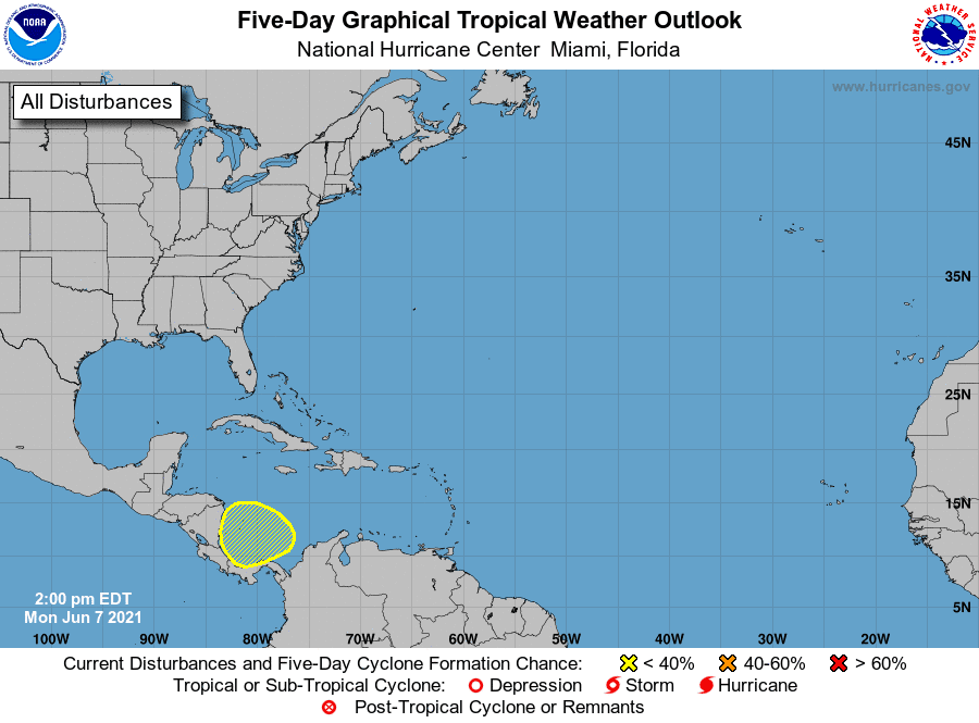
Tropical Weather Outlook
Weather conditions are currently quiet across the Atlantic, the Caribbean Sea and the Gulf of Mexico.
National Hurricane Center forecasters are closely monitoring the southwestern Caribbean Sea where an area of low pressure is expected to develop by Thursday or Friday. Some gradual development will be possible thereafter as the system moves slowly northwestward toward Central America. NHC forecasters are giving this system a 20 percent chance for tropical development over the next 5 days.
Have a good week.
Bob
Social Media