A quiet and dry weather pattern is in place as we start off the new week. A cold front pushed south through the area Sunday, allowing drier and slightly cooler air to spread into the region. In the middle and upper atmosphere, a trough of low pressure will be developing south through the middle Mississippi Valley this week, helping to pull additional dry air into Texas. A northerly wind flow on the back side of the trough is expected to keep the atmosphere dry and quite stable throughout the week. As a result, sunny and dry weather is forecast all of this week and through the upcoming weekend. Do note, a ridge of high pressure located over northern Mexico is forecast to strengthen late week and this weekend. This feature will also contribute to the dry weather pattern, while making daytime temperatures feel very summer-like. Nighttime temperatures are predicted to remain fairly comfortable.
- High temperatures this afternoon through Wednesday are forecast to be near 88-90 degrees.
- High temperatures Thursday through Sunday will include the low 90s across the Hill Country, the low to mid-90s across Central Texas and be near 90 degrees across the coastal plains.
- Low temperatures Tuesday morning through Thursday morning will include the upper 50s across the Hill Country, the upper 50s to low 60s across Central Texas and the low 60s across the coastal plains.
- Low temperatures Friday morning through Sunday morning will include the low 60s across the Hill Country, the mid-60s across Central Texas and the upper 60s across the coastal plains.
Looking ahead to next week, forecasts indicate we may see the development of a few spotty rain showers and isolated thunderstorms Sunday night into Monday morning when a weak Pacific cold front tracks southeast across the state. With little moisture in place, the rain should be quite limited. Rainfall, if any, should total less than a tenth of an inch. Monday’s weather is shaping up to be partly cloudy, with high temperatures in the low 90s.
Next Tuesday’s weather is forecast to be sunny and dry, with a high temperature in the low 90s.
There will be a slight chance for a few spotty rain showers and isolated thunderstorms next Wednesday when a another weak cold front is forecast to sweep through the area. Once again, the rain should be very limited.
Mostly sunny, dry and slightly cooler weather will follow the cold front next Thursday and Friday, with highs in the upper 80s.
Tropical Weather Update
Weather conditions continue very quiet across the Gulf of Mexico and the Caribbean Sea. There are no systems in place which pose a threat for tropical development for at least the next 5 days.
Across the remainder of the tropical Atlantic, National Hurricane Center forecasters are monitoring Hurricane Sam and an area of disturbed weather across the Bahamas and the southwestern Atlantic. Tropical Storm Victor degenerated into a trough of low pressure over the central Atlantic earlier this morning.
As of 10 am CDT, the center of Hurricane Sam was located about 460 miles southeast of Cape Race, Newfoundland. Sam was moving toward the northeast near 32 mph. A faster northeastward motion is expected through tonight. A slower east-northeastward motion is forecast to begin on Tuesday and continue through midweek. Maximum sustained winds were near 100 mph with higher gusts. Gradual weakening is forecast during the next few days, and Sam is expected to transition into a powerful post-tropical cyclone over the north Atlantic Monday night or early Tuesday.
A large area of disorganized cloudiness and showers over the southeastern Bahamas and adjacent southwestern Atlantic waters are associated with a surface trough of low pressure. Upper-level winds are not expected to be favorable for significant development of this system while it moves slowly northwestward over the next several days. By this weekend, the system is forecast to merge with a front near the coast of the southeastern United States. NHC forecasters are giving this system a low chance, a 10 percent chance, for tropical development over the next 5 days.
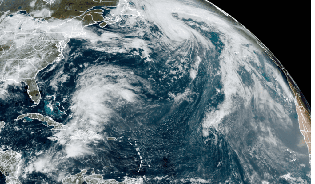
NOAA/Colorado State University/RAMMB 10/04/21 12:20 pm CDT
Have a good week.
Bob
Social Media