Very welcome rain spread across the region on Saturday. Amounts were heaviest around the Austin area where some locations saw totals of 1.5-1.8 inches. LCRA’s highest gauged total was 1.8 inches along Wilbarger Creek near Elgin, in northwestern Bastrop County. Totals were considerably lower across the Hill Country and also over the area between Bastrop and Columbus. Much of the northern and western Hill Country saw zero precipitation. Meanwhile across the coastal plains region, most totals averaged around an inch.
NWS Estimate of Rain Falling Between 9 am Friday and 9 am Monday:
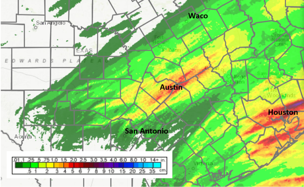
Data courtesy National Weather Service
Weather conditions are clear and quiet across Central and South Texas on this Monday. The cold dome of Canadian high pressure which spread into the area behind Saturday’s rain is moving off the east. This has brought a return of southerly breezes off the Gulf of Mexico. A very stable atmosphere is in place. This afternoon’s weather will be sunny and mild with the temperature warming to 70-73 degrees. Lows Tuesday morning will range from around 40 degrees across the Hill Country to the upper 40s near the coast.
The sky will be mostly clear Monday night but an area of fog is forecast to develop across the coastal plains and most of Central Texas late Monday night, continuing through about mid-morning Tuesday. The fog and low clouds should are expected to burn off late morning, with the sky becoming mostly sunny in the afternoon. Tuesday’s temperature should again warm to the low 70s. Southerly breezes will increase to 10-15 mph in the afternoon. The sky will become mostly cloudy Tuesday night. Lows Wednesday morning will noticeably warmer, mainly in the mid and upper 50s.
A trough of low pressure tracking east across the Plains states will help to push a cold front across Texas on Wednesday. The front is predicted to reach the northern Hill Country late Wednesday morning, the Austin area around mid-afternoon and the coastal plains region in the late afternoon. Ahead of front, the sky will be cloudy Wednesday morning, becoming partly cloudy in the afternoon. Expect gusty southwesterly breezes at 10-15 mph with gusts to 25 mph. Behind the front, the wind will shift to the northwest at similar speeds through Wednesday night. High temperatures will be around 68-72 degrees across the Hill County and Central Texas regions and in the mid to upper 70s near the coast.
A few light rain showers may accompany the cold front—mainly for areas to the east of Interstate 35. Totals should average less than a tenth of an inch.
A clear sky and colder temperatures will follow the cold front Wednesday night into Thursday.
- Lows Thursday morning will be near 28-30 degrees across the Hill Country, the low and mid-30s across Central Texas and the upper 30s towards the coast.
- High temperatures Thursday will be in the mid and upper 50s.
- Lows Friday morning will be near 30 degrees across the Hill Country, in the low 30s across Central Texas and the mid-30s across the coastal plains.
Christmas Day weather is expected to be sunny, with a high temperature in the low 60s. Lows Saturday morning will range from the mid-30s west to the mid-40s near the coast.
Forecasts call for a weak trough of low pressure to track east across North Texas on Saturday. This system is expected to bring a few light rain showers to parts of Central Texas and the coastal plains region on Saturday. Rainfall, if any, should total less than a tenth of an inch. Mostly sunny conditions look to develop Saturday afternoon and continue through Sunday. High temperatures Saturday will be in the low 60s, warming to the upper 60s on Sunday.
The outlook for next week calls for mostly sunny and dry weather for Monday and Tuesday. High temperatures will be in the 60s, with low temperatures in the 40s.
A large trough of low pressure is forecast to track from the Desert Southwest to Texas around the middle of next week. Forecasts call for an increasing chance for rain showers and isolated thunderstorms Wednesday into Thursday. Rain amounts of at least a half inch are forecast. Sunny and slightly cooler weather should follow on New Year’s Day.
Jupiter and Saturn’s great conjunction is Tonight
Just step outside about a half hour to forty five minutes after sunset tonight and look southwest. Jupiter and Saturn will be having their finest conjunction since the Middle Ages–and they’re bright. At closest approach on Dec. 21st, the two planets will lie just 0.1 degrees apart. That’s so close, some people will perceive them as a single brilliant star. Viewed through binoculars or a small telescope, Saturn will appear as close to Jupiter as some of Jupiter’s moons.
Find more information, including a sky map at spaceweather.com
Happy Holidays!
Bob
Social Media