A wet and unsettled weather pattern will continue across the region this afternoon as an area of low pressure over south Texas pulls considerable moisture inland from the Gulf of Mexico. This same low pressure system has brought very heavy rain to the Coastal Bend and the middle Texas coast for the past couple of days. It has been an unusually wet week for this area, with significant rains falling last weekend in addition to the rains over the past couple of days. Rockport recorded a total of more than 16 inches over the past 3 days alone.
The following chart shows the estimated amount of rain falling across the Coastal Bend and the middle Texas coast between 7 am last Friday and 7 am Friday morning. Note the western half of Matagorda County has seen between 10 and 15 inches, while southern Wharton County has received between 6 and 10 inches.
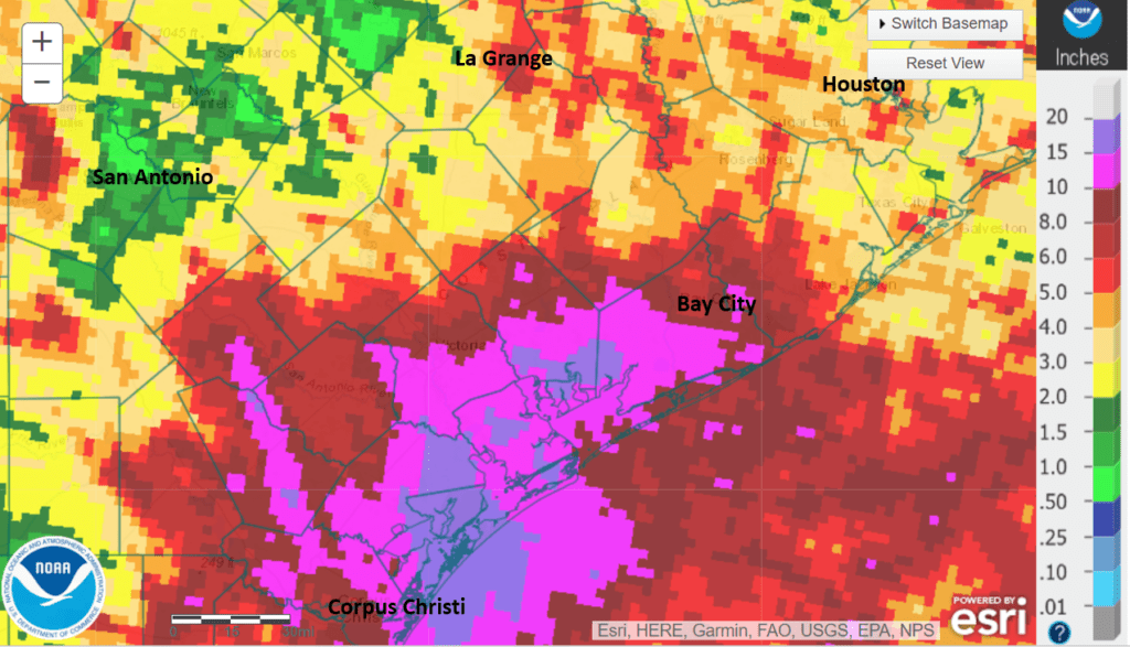
Data courtesy NWS West Gulf River Forecast Center
Friday’s weather maps showed the persistent area of low pressure centered to the west of San Antonio, near Uvalde. The low wasn’t moving very fast and appeared to be just drifting to the west. A counterclockwise wind flow around the low was pulling deep tropical moisture inland, causing the development of showers and isolated thunderstorms. As of early afternoon, the heaviest rains were falling across the middle Texas coast between Columbus and Matagorda.
This afternoon into this evening, bands of light to moderate showers and isolated thunderstorms are forecast to continue moving across much of the area. The most widespread and heaviest rains are forecast to persist along the middle Texas coast, to the south of Interstate 10. The rain is forecast to decrease in areal coverage this evening after sunset. The chance for rain looks to decrease to 20 percent after midnight across the Hill Country and Central Texas regions and to 30 percent across the coastal plains. Rain totals from this afternoon till midnight are forecast to generally average between a quarter and a half inch across the Hill Country and most of Central Texas, with isolated totals of 1-2 inches possible. For the middle Texas coast, additional totals of 2 to 4 inches are forecast, with isolated heavier totals in excess of 6 inches possible. Afternoon temperatures will be mild, with highs generally in the low and middle 80s.
A somewhat drier pattern is forecast to begin taking shape Saturday as the large area of low pressure over South Texas gets steered west into Mexico, causing the feed of tropical moisture to decrease. There will still be a 20-30 percent chance for scattered rain showers and isolated thunderstorms, but widespread or heavy rain is not expected. Rain totals Saturday are forecast to generally average around a quarter inch, or less. Morning clouds are predicted to give way to a partly cloudy to mostly sunny sky by afternoon. Saturday’s temperature is forecast to warm close to 90 degrees.
Sunday’s weather is shaping up to be mostly sunny to partly cloudy across the region. However, there will be a 30-40 percent chance for the development of scattered thunderstorms across the northern and western Hill Country Sunday afternoon and across the rest of the Hill Country and Central Texas regions Sunday evening and Sunday night as a weak cold front sags south into North Texas. Showers and thunderstorms developing along the front are forecast to track south into the Hill Country and Central Texas regions. For areas that see rain, expect totals to average between 0.25 and 0.5 inches. High temperatures Sunday are forecast to be near 90-93 degrees.
There will be a 30 percent chance for scattered showers and thunderstorms across the entire region Monday as the weak cold front stalls out near Interstate 20. Rain amounts are forecast to average around a quarter inch. Expect a partly cloudy to mostly sunny sky, with high temperatures near 90-93 degrees.
For next Tuesday through Friday, forecasts call for a fairly typical summertime pattern to develop as a weak ridge of high pressure spreads over Texas out the west. The center of the high pressure ridge is forecast to remain out west near the Four Corners region, keeping the hottest temperatures west of Texas. Areas along and east of Interstate 35 will see a slight chance for a few spotty rain showers each afternoon and evening, but rain amounts should only average around a tenth of an inch. In general, expect a most sunny sky each day, with high temperatures in the low to mid-90s.
Looking out to next weekend and the following week, forecasts call for continued summer-like conditions, with just a slight chance for a few spotty afternoon showers. Temperatures are forecast to trend warmer, with high temperatures generally in the mid-90s.
Tropical Weather Outlook
Post-Tropical Cyclone Elsa was located early Friday afternoon over southern New England, moving to the northeast.
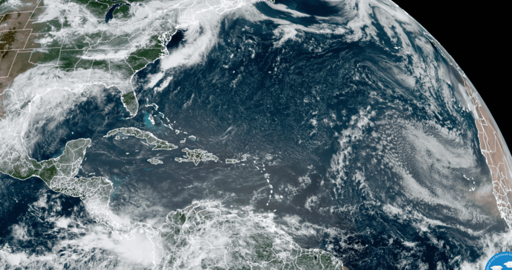
NOAA/Colorado State University/RAMMB–07/09/2021 10:30 am CDT
Weather conditions are quiet across the tropical Atlantic, the Caribbean Sea and the Gulf of Mexico. Tropical cyclone formation is not expected for at least the next five days.
New Moon and Viewing the ISS
New Moon will occur Friday evening at 8:16 pm. Saturday and Sunday evenings, watch for a thin crescent Moon in the western sky shortly after sunset. The moon will be hanging to the right of Venus Sunday evening.
Each day next week will offer two opportunities to see the International Space Station float across our summer sky. There will be two opportunities to see the ISS Monday evening. Tuesday through Friday will offer an opportunity just before sunrise with another shortly after sunset. Find out the times and locations to view the ISS for your particular location through NASA’s Spot the Station website: https://spotthestation.nasa.gov
Have a good weekend.
Bob
Social Media