A large area of rain and thunderstorms spreading across the Hill Country and Central Texas Thursday morning into Thursday afternoon. This area of rain was being generated by the latest wave of low pressure to move through a large trough of low pressure stretching from western Texas to the Great Lakes region. According to LCRA’s Hydromet, this system produced widespread totals of 1-2 inches over the area between Junction, Mason, Fredericksburg, South Austin and Bastrop. There were even a couple of reports of totals over 3 inches.
High-resolution forecasts call for the area of rain and thunderstorms to slowly exit the Hill Country and across Central Texas regions Thursday evening. Scattered showers and thunderstorms are forecast to spread persist across the middle Texas coast through late Thursday evening. While the threat for widespread severe weather is low, a couple of thunderstorms may produce small hail and gusty winds. There will be considerable, dangerous lightning. Rainfall through late evening is forecast to average around an inch, with isolated totals to near 2 inches possible.
The outlook for Thursday night calls for a 30 percent chance for scattered light showers and isolated thunderstorms. The high-resolution forecasts do not call for any widespread or heavy rainfall.
A wet and unsettled weather pattern is expected to continue Friday through the weekend as a piece of the large upper trough cuts off and sets up over south central Texas. Waves of low pressure rotating around the trough are forecast to produce periods of showers and thunderstorms. There are some indications the afternoon and evening periods will be the most favored time periods for rain and storms. Forecasts call for daily rain amounts of 0.5 to 1 inch, with isolated totals of 2-3 inches possible. The threat for widespread severe storms appears low, but a few storms may produce large hail and strong winds.
More showers and thunderstorms are forecast across the region next Monday and Tuesday. However, the upper trough is forecast to weaken and begin lifting slowly to the north. This should shift the heaviest and most widespread rain to areas along and east of Interstate 35. Daily rain amounts are forecast to generally average between a quarter and a half inch, with isolated heavier totals.
Forecasts call for the chance for widespread rain to decrease next Wednesday through Friday as the upper trough moves further to the north. Nevertheless, scattered showers and thunderstorms will likely continue, mainly in the afternoon and evening hours.
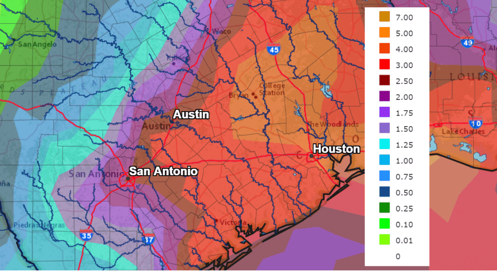
The National Weather Service’s rainfall forecast for the next 5 days calls for totals of 3-5 inches for locations along and east of Interstate 35. Totals of 1-3 inches are forecast for locations to the west of Interstate 35.
NWS Rainfall Forecast for the Period 7 pm Thursday through 7 pm Tuesday:
The ground is very wet and in some cases saturated from the recent rains. Any additional rain over the next few days will runoff quickly, increasing the threat for flash flooding. If you approach a flooded road, remember to Turn Around, Don’t Drown.
Bob
Social Media