Rain and scattered thunderstorms spread across the region Monday night into early Tuesday morning as another wave of low pressure tracked across the region out of northern Mexico and northwest Texas. This is part of the same unsettled pattern that has been in place since early last week. Early this afternoon, all of the rain had exited the region as the wave of low pressure exits to the east. A break from the widespread rain is forecast this afternoon as our region remains between waves of low pressure. There will still be a slight chance for a few brief showers and isolated thunderstorms this afternoon and tonight—mainly for areas east of Interstate 35. The probability for rain will be 20 percent this afternoon and 40 percent overnight. Today’s sky will be mostly cloudy and high temperatures only be in the low and mid-80s.
A wet and unsettled weather pattern is forecast throughout the week and the upcoming weekend. Tuesday’s weather maps showed a large trough of low pressure in the middle and upper atmosphere stretching from the Great Lakes to northwest Texas. This trough is forecast to remain essentially stationary through late week and will allow a series of small waves of low pressure to move over the area. Each wave will have the potential to cause the development of widespread showers and thunderstorms between Wednesday and Friday. The probability for rain each day will be near 70-80 percent. Despite having high-resolution forecast data, trying to time the passage of these waves of low pressure is not very clear. Rainfall forecasts call for daily totals to average between 0.5 and 1 inch, with isolated heavier totals. With the ground currently quite wet and in some cases saturated from recent rains, these additional rains will cause efficient runoff and could lead to flash flooding.
The threat for severe storms Wednesday through Friday is forecast to be low.
High temperatures Wednesday through Friday are forecast to generally be in the low and mid-80s.
The outlook for the upcoming weekend calls for more periods of rain and storms across the region as a piece of the upper trough situated over the state breaks off and very slowly meanders to the east. With the atmosphere quite moist and unstable, the probability for rain will remain near 70-80 percent. Rain amounts each day are forecast to average between 0.5 and 1 inch, with isolated heavier totals. High temperatures are forecast to be mostly in the mid-80s.
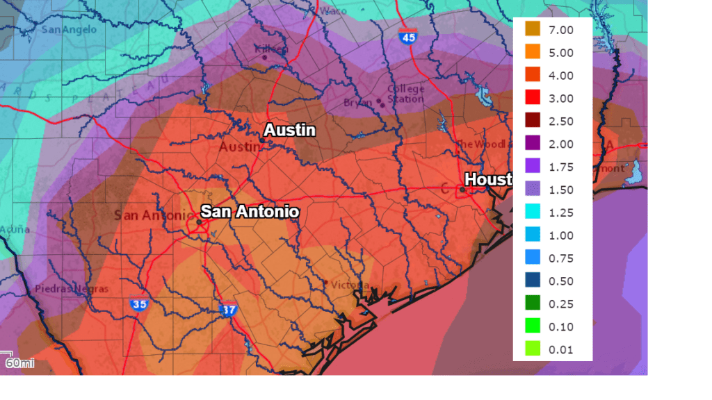
Forecast solutions are indicating it will be a very wet period over the next five days. Forecasts for the period between Tuesday evening and Sunday evening call for widespread totals of 3-5 inches for the eastern Hill Country, all of Central Texas and the middle Texas coast. Slightly lower totals are forecast across the western and northern Hill Country.
NWS Rainfall Forecast for the Period 7 pm Tuesday through 7 pm Sunday:
Looking ahead to next week, forecast solutions call for the wet and unsettled pattern to continue through at least Tuesday as more waves of low pressure continue to move over the region. Rain amounts on both Monday and Tuesday are forecast to average around a half inch. The wet pattern is forecast to ease some beginning next Wednesday as the trough of low pressure finally pushes east and a weak ridge of high pressure begins to move in from the west. However, a slight chance for mainly afternoon showers and thunderstorms will continue. Expect daily high temperatures to be in the upper 80s.
While the wet pattern is forecast to ease some next week, updated outlooks for the month of June call for it to be a wet month, with above normal rainfall and below normal temperatures.
Tropical Weather Outlook
Today marks the first day of the Atlantic hurricane season, which will run until November 30. Currently, weather conditions are very quiet across the Atlantic, the Caribbean Sea and the Gulf of Mexico and tropical storm development is not expected over the next 5 days.
NOAA’s Climate Prediction Center is predicting another above-normal Atlantic hurricane season. For 2021, NOAA is predicting a likely range of 13 to 20 named storms (winds of 39 mph or higher), of which 6 to 10 could become hurricanes (winds of 74 mph or higher), including 3 to 5 major hurricanes (category 3, 4 or 5; with winds of 111 mph or higher). NOAA provides these ranges with a 70% confidence.
Long-term averages for the number of named storms, hurricanes, and major hurricanes are 14, 7, and 3, respectively.
May Rainfall
The month of May turned out to be unusually wet across Central and South Texas. Totals generally ranged between 2 and 6 inches across the Hill Country and between 6 and 10 inches across Central Texas. Totals of 10-20 inches were recorded From Fayette County, southeast to the middle Texas coast. While this wasn’t quite as wet as May 2015, for many location it still ranked among some of the wettest Mays on record.
In Austin, Camp Mabry recorded a monthly total of 7.23 inches, which is 2.19 inches above normal. May 2021 ranks as the 26th wettest May on record. At Austin-Bergstrom, the monthly total was 12.27 inches, which is 7.27 inches above normal. May 2021 ranks as the 4th wettest May on record dating back to 1942.
Bob
Social Media