A wet and unsettled weather pattern is beginning to take shape across our region and this pattern is forecast to continue through mid-week.
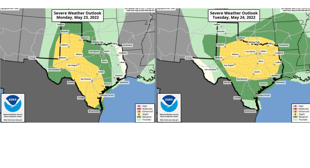
Although the weather has been quiet and dry through the morning hours, forecasts call for scattered rain showers and thunderstorms to develop across West and Southwest Texas this afternoon as a trough of low pressure begins to move northeast out of Mexico. The rain and scattered thunderstorms are predicted to track to the east-northeast, spreading across the Hill Country and the Austin/Interstate 35 corridor beginning late this afternoon and evening. Widespread rain shower and thunderstorm activity is forecast to continue across the Hill Country this evening and overnight while at the same time, the rains expand east to Central Texas and the middle Texas coast. The atmosphere across the Hill Country and Central Texas regions is forecast to be fairly unstable, allowing some of the storms to be strong to severe. The primary severe weather threats will be large hail and damaging straight-line winds. However, there will be a low chance for a couple of isolated tornadoes. The Storm Prediction Center has placed the Hill Country and all of Central Texas under a Slight Risk (a 2 out of 5 risk) for severe thunderstorms through 7 am Tuesday morning.
Forecasts call for rain and scattered thunderstorms to persist overnight, with the activity decreasing from west to east late Monday night into Tuesday morning. Totals of 1-1.5 inches, with higher totals can be expected. A mostly dry Tuesday morning can be expected.
The period of dry weather Tuesday morning is expected to be short-lived as a second, vigorous trough of low pressure begins to track into South Texas out of Mexico. Forecasts call for an increasing chance for rain showers and thunderstorms across the region Tuesday afternoon into Tuesday night. Once again, the atmosphere is forecast to structured in a way that will allow some of the storms to be strong to severe. The Storm Prediction Center has placed all of the Hill Country and all of Central Texas under a Slight Risk (a 2 out of 5 risk) for severe thunderstorms Tuesday through Tuesday night. The primary severe weather threats will be damaging straight-line winds and large hail. In addition, periods of moderate to heavy rain will also be possible Tuesday afternoon through Tuesday night.
Severe Weather Risk Tuesday and Wednesday:
The chance for rain and scattered thunderstorms is forecast to continue Tuesday night into Wednesday as a cold front slowly pushes south out of North Texas. Forecasts call for a large complex of rain and thunderstorms to develop along and behind the cold front as it slowly moves to the south. The cold front is forecast to reach the Interstate 35 corridor around sunrise Wednesday, pushing off the middle Texas coast by about mid-afternoon. Locally heavy rain will be possible with this area of rain along and behind the cold front. The rain is forecast to taper off from north to south Wednesday afternoon as a more stable atmosphere develops behind the cold front. The rains should taper off across the coastal region Wednesday evening. Totals between Tuesday and Wednesday evening are forecast to generally average between 1 and 3 inches, with isolated heavier totals.
Temperatures will trend cooler behind Wednesday’s cold front, with high temperatures forecast to be in the mid-70s across the Hill Country and Central Texas regions, and in the mid-80s across the coastal plains.
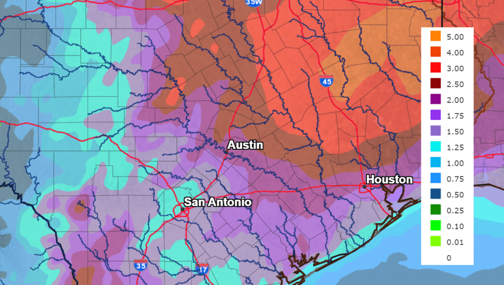
National Weather Service forecasts call for rain totals between Monday afternoon and Wednesday night to generally average between 1 and 2.5 inches across the Hill Country, and be between 2 and 4 inches across Central Texas and the middle Texas coast.
NWS Rainfall Forecast for the Period 7 am Monday through 7 am Thursday:
A sunny and dry weather pattern is forecast to resume Thursday as a stable ridge of high pressure begins spreading over Texas out of Mexico. These sunny and dry conditions are forecast to remain in place through Memorial Day and the middle of next week. High temperatures are forecast to be in the mid-80s Thursday, into the upper 80s Friday, and be in the low 90s Saturday and Sunday. High temperatures Memorial Day are forecast to be in the mid-90s.
Bob
Social Media