June has certainly started off wet across Central and South Texas. Waves of rain and thunderstorms have spread across the region, with each wave producing significant totals of rain. Forecasts call for the wet pattern to continue through the weekend and early next week, with the rain finally decreasing in areal coverage and intensity beginning next Wednesday. While the second half of next week won’t contain a totally dry forecast, the rain is expected to become more spotty in nature, with considerably lower totals.
Early Friday afternoon, scattered rain showers and isolated thunderstorms were just beginning to develop across the Hill Country and Central Texas regions. Friday’s weather maps showed a large area of low pressure in the upper atmosphere centered over west-central Texas. This feature is forecast to remain nearly stationary through the weekend, then slowly lift off to the northeast early next week. The combination of weak atmospheric lift associated with the upper low, weak waves of low pressure rotating around the low and a very moist atmosphere is expected to cause the development of numerous rain showers and scattered thunderstorms across the area today through Sunday. The wet pattern appears to be trending to one that features a build up of showers and thunderstorms in the late morning and midday hours, with rain and storms persisting through the afternoon and evening. The activity is then forecast to decrease in the late evening. A few heavy downpours will be possible. There will be some dry periods with a few peeks of sunshine from time to time over the next couple of days.
This afternoon through Sunday, the probability for rain will be near 60-70 percent during the afternoon and evening hours, with the probability for rain decreasing to 30 percent overnight. Daily high temperatures through Sunday are forecast to be in the low and middle-80s.
Daily rain amounts today through Sunday are forecast to generally average between 0.5 and 1 inch. A couple of isolated totals to around 2 inches will be possible.
Looking at next week, mainly daytime and evening rain showers and isolated thunderstorms are forecast across the area Monday and Tuesday as the upper low slowly pulls off to the northeast. The probability for rain each day will be near 40-50 percent with daily rain amounts both days forecast to be around a half inch. A few isolated heavier totals will be possible. High temperatures will be in the middle to upper 80s.
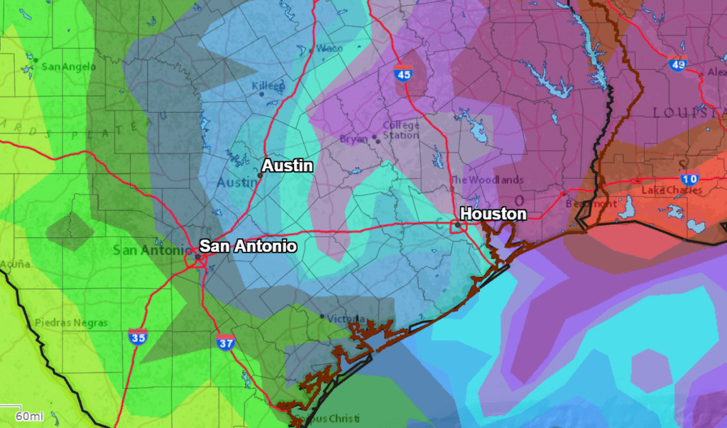
The National Weather Service’s 5-day Rainfall Forecast calls for totals to near an inch across the Hill Country and totals of 1-2 inches for locations along and east of Interstate 35.
NWS Rainfall Forecast for the Period 7 pm Friday through 7 pm Wednesday:
For next Wednesday through Friday, scattered mainly afternoon and evening showers and isolated thunderstorms are forecast as the atmosphere remains quite moist and slightly unstable. The probability for rain each day will be around 30 percent , with rain amounts averaging around a quarter inch or less. Daily high temperatures look to be in the upper 80s.
The outlook for next weekend calls for just a slight chance for showers as a weak ridge of high pressure attempts to set up across the region. Expect a partly cloudy sky with high temperatures around 88-90 degrees. Longer-range outlooks call an unsettled weather pattern returning to our area the week of June 14th as the ridge of high pressure weakens and a broad area of low pressure spreads over Texas out of the southern U.S.
Earliest Sunrise of the Year
Although the summer solstice isn’t until June 20th, the earliest sunrises of the year will be taking place beginning Saturday, continuing through next Tuesday , June 15th. In Austin, sunrise on these days will be at 6:28 am CDT. You might be interested to note the latest sunsets of the year won’t occur until late June and the first week of July.
Have a good weekend.
Bob
Social Media