A wet and unsettled weather pattern is forecast to develop across the region Friday afternoon, with the pattern continuing through the long holiday weekend. Friday’s weather maps showed an unusually strong trough of low pressure digging south into the Lower Mississippi Valley. Forecasts call for the trough to remain in nearly the same location through the middle of next. A weak cold front associated with the trough located just south of the Red River is predicted to sag south this afternoon and tonight, pulling up stationary somewhere across Central Texas this weekend and early next week. The combination of a weakened ridge, the stalled frontal boundary and waves of low pressure tracking south on the back side of the large upper trough is expected to cause periods of rain showers and thunderstorms region-wide this weekend, continuing through the first half of next week. One additional ingredient in the upcoming unsettled pattern will be an unusually moist atmosphere. Forecasts call for a plume of rich, tropical air to spread into Texas this weekend. This high moisture content will allow for the development of locally heavy downpours from time to time across the region. The threat for severe storms this weekend and next week is expected to be low, but some of the stronger storms may produce strong and gusty winds.
This afternoon and Tonight
Forecasters will be monitoring the progress of an outflow boundary pushing south out of North Texas. High-resolution forecasts call for the boundary to reach the Hill Country around mid-afternoon, the Austin area in the late afternoon/early evening and the La Grange area around mid-evening. Scattered thunderstorms are forecast to develop near and behind the boundary this afternoon and evening. For areas that see rain, totals are forecast to average between 0.25 and 0.5 inches, with isolated totals of 1-2 inches possible. Ahead of the advancing boundary, expect a partly cloudy sky and hot temperatures, with readings reaching the mid and upper 90s.
Saturday, Independence Day, Monday and Tuesday
Expect a mostly cloudy sky through the period. There will be a 60-70 percent chance for rain showers and scattered thunderstorms each day. The most favorable period for rain each day will be between late morning and early evening. On Independence Day, much of the rain activity is forecast to decrease Sunday evening, but do note there still may some showers around at fireworks time. Daily rain amounts are forecast to generally average around a half inch. Isolated heavy downpours may produce totals of 2-3 inches. Daily high temperatures are forecast to be around 88-90 degrees.
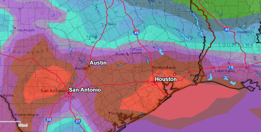
Total rainfall between this afternoon and next Wednesday morning is forecast to generally average between 2 and 3.5 inches, with isolated heavier totals
NWS Rainfall Forecast for the Period 7 pm Friday through 7 pm Wednesday:
Next Wednesday through Friday
The large upper trough is forecast to lift off to the northeast. But a piece of the trough is predicted to break off and track southwest toward the Rio Grande Plains. The circulation around upper trough will continue to pull tropical moisture inland across Central Texas and the Hill Country, resulting in more periods of showers and thunderstorms. Daily rain amounts are forecast to average around a half inch, with isolated totals of 2-3 inches possible. The probability for rain each day looks to be near 60-70 percent. Expect mostly cloudy sky with daily high temperatures near 88-90 degrees.
Next Weekend into the Early Part of the Following Week
The upper low is forecast to track west into Mexico. Lingering tropical moisture will cause a slight chance for mainly afternoon rain showers and thunderstorms. Otherwise, expect a partly cloudy sky, with high temperatures in the low and mid-90s.
Tropical Weather Outlook
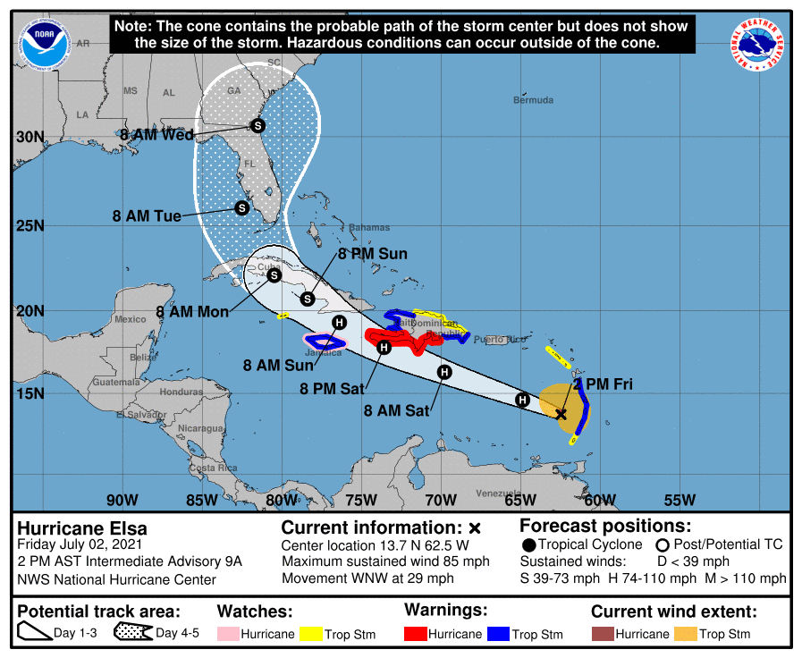
All eyes are on recently upgraded Hurricane Elsa. The majority of the forecast guidance calls for Elsa to track somewhere toward the eastern Gulf of Mexico and Florida by about Tuesday or Wednesday of next week. A track towards the western Gulf and Texas appears quite low, but the latter part of Elsa’s forecast track is still somewhat uncertain. I urge everyone to keep up with the latest advisories from the National Hurricane Center over the long weekend.
Elsewhere across the tropical Atlantic, conditions are quiet and there are no features which pose a threat for tropical development over the next 5 days.
As of 1 pm CDT, the center of Hurricane Elsa was located just west of the Windward Islands, about 95 miles west-northwest of St. Vincent. Elsa was moving toward the west-northwest near 29 mph, and this motion is expected to continue during the next couple of days, with some decrease in forward speed expected Sunday night. On the forecast track, Elsa will move away from the Windward Islands Friday afternoon, move across the eastern Caribbean Sea Friday afternoon and Friday night, and move near the southern coast of Hispaniola late Saturday or Saturday night. By Sunday, Elsa is forecast to move near Jamaica and portions of eastern Cuba, and move near portions of central and western Cuba Sunday night and early Monday.
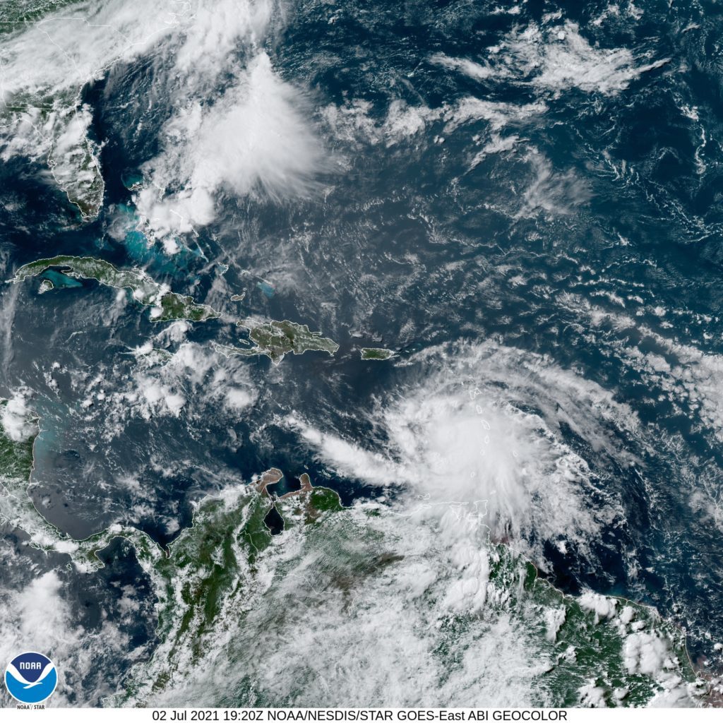
Reports from a NOAA Hurricane Hunter aircraft indicate that maximum sustained winds are now near 85 mph with higher gusts. Little change in strength is forecast during the next 48 hours. Some decrease in winds is possible on Monday as Elsa interacts with Cuba.
Wishing everyone a safe and happy Independence Day and holiday weekend!
Bob
Social Media