Isolated to scattered showers and thunderstorms can be expected Wednesday afternoon as our region remains under the influence of an unusually moist flow off the Gulf of Mexico. Expect a partly to mostly cloudy sky. The temperature should warm to the mid and upper 80s and be close to 90 degrees towards the coast.
A widespread, heavy rainfall event is expected to take shape early this evening along the Rio Grande as the remnants of eastern Pacific Hurricane Pamela begin spreading northeast out of northern Mexico. Pamela made landfall along the west coast of Mexico early Wednesday morning, just north of Mazatlan. While the mountains of western Mexico are expected to “wring out” much of the storm’s tropical moisture, the storm’s remnant low pressure center is forecast to survive the journey and reach a position just south of Del Rio by about midnight tonight. The low is forecast to track northeast across the Hill Country overnight and move into North Texas Thursday morning.
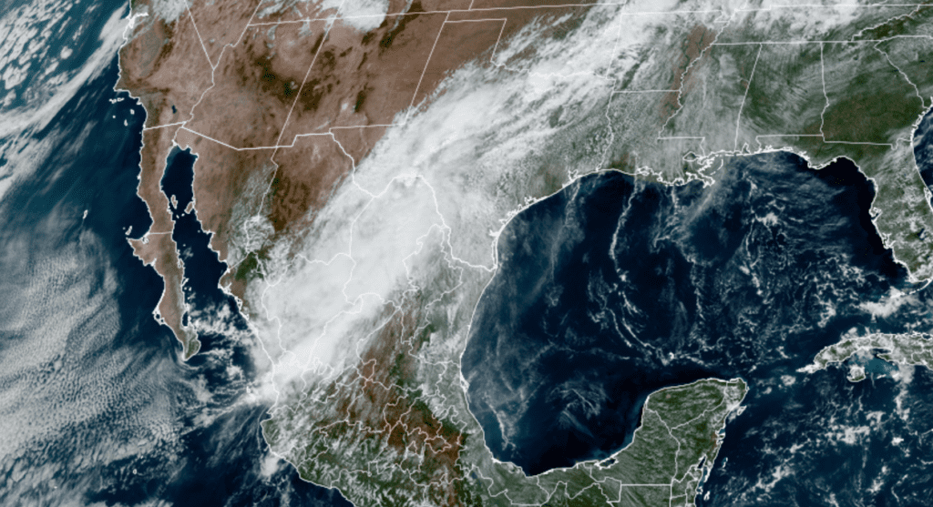
NOAA/Colorado State University/RAMMB 10/13/21 1:30 pm CDT
Pamela’s remnant low pressure area is forecast tap into the very moist atmosphere currently in place across Central and South Texas. Forecasts call for a widespread area of showers and thunderstorms to develop across the Rio Grande plains Wednesday evening, with the activity spreading northeast into the Hill Country and the Interstate 35 corridor by late evening. Widespread moderate to heavy rain and embedded scattered thunderstorms are predicted to move across both regions overnight, continuing into Thursday morning. The rain is predicted to taper off from west to east Thursday morning as the remnant low exits to the northeast. For locations east of Interstate 35, showers and thunderstorms are forecast to increase late tonight and persist through late Thursday morning, with the rain tapering off in the early afternoon.
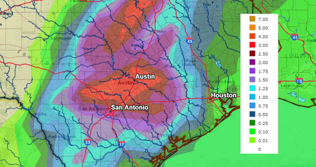
Rainfall forecasts through Thursday afternoon call for widespread totals of 2-5 inches across most of the Hill Country and the Intestate 35 corridor, including metro Austin, Georgetown, San Marcos and New Braunfels. Isolated totals of 5 to 7 inches will also be possible at a few locations. East of Interstate 35, totals of around an inch are forecast between Bastrop and La Grange. From La Grange, south to the middle Texas coast, totals are forecast to average around a half inch.
NWS Rainfall Forecast for the Period 7 pm Wednesday through 7 pm Saturday:
Due to the threat for heavy rain, the National Weather Service has posted a Flash Flood Watch through late Thursday afternoon for areas along and west of Interstate 35.
A partly cloudy sky is forecast Thursday afternoon through Thursday night.
A strong Canadian cold front is forecast to sweep southeast across the Hill Country Friday morning, reaching the Interstate 35 corridor midday. The front is forecast to continue moving southeast, pushing off the middle Texas coast by late Friday afternoon. There will be a slight chance for a few scattered rain showers and isolated thunderstorms along the cold front for locations near and southeast of La Grange. No rain is expected across the Hill Country or most of Central Texas.
Sunny, dry and fall-like weather is forecast behind the cold front this weekend and all of next week. High temperatures Saturday and Sunday look to be in the mid and upper 70s. Lows Sunday and Monday mornings will range from the low 40s across the Hill Country to the low 50s near the coast.
Bob
Social Media