Thunderstorm complexes which developed across South Texas Monday night have moved out of our area and are now tracking across the upper Texas coast. Unfortunately, Monday night’s rain and thunderstorms missed the majority of our region. An area of heavy rain and storms did move over parts of San Saba, Mills, and Lampasas Counties, producing widespread totals 0.5 to 1 inch. An LCRA gauge located along the Colorado River at San Saba recorded a 24-hour total of 2.63 inches, while another gauge in eastern Mills County recorded 2.37 inches.
In the wake of Tuesday night’s storms over South Texas, the atmosphere has temporarily stabilized across the Hill Country and Central Texas regions. Expect a partly cloudy sky with just a slight chance for a few isolated rain showers and thunderstorms around the area this afternoon. Today’s temperature looks to warm into the mid-80s.
Forecast confidence has increased for the development of widespread rain showers, thunderstorms and possible severe thunderstorms across the region Tuesday evening through Wednesday morning. A vigorous trough of low pressure tracking southeast through the Texas Panhandle this afternoon is forecast to cause the development of thunderstorms across West and Northwest Texas late this afternoon. The area of storms is predicted to evolve into a large complex of rain and thunderstorms over the Concho Valley and Big Country area early this evening. The leading edge of the storm complex is forecast to spread southeast across the Hill Country through the evening hours, reaching the Austin/Interstate 35 corridor around midnight, the La Grange area around 3 am and the coastal plains region in the hours before sunrise.
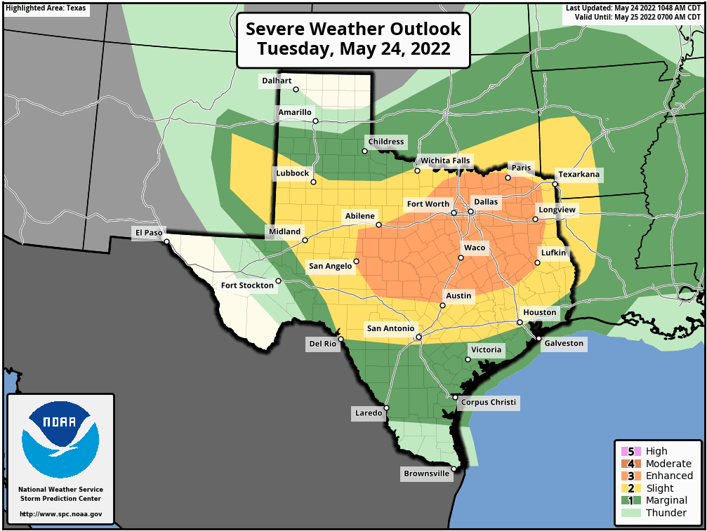
Atmospheric conditions in advance of the large storm complex are forecast to be favorable for some of the thunderstorms to become strong and severe. The Storm Prediction Center has placed the northern Hill Country and the area just to the north of Austin under an Enhanced Risk (a 3 out of 5 risk) for severe thunderstorms. Much of the rest of the region has been placed under a Slight Risk (a 2 out of 5 risk) for severe thunderstorms. Wharton and Matagorda Counties have been placed under a Marginal Risk (a 1 out of 5 risk) for severe thunderstorms) through 7 am Wednesday. The primary severe weather threat is forecast to be damaging straight-line winds, followed by large hail, and a couple of spin-up tornadoes.
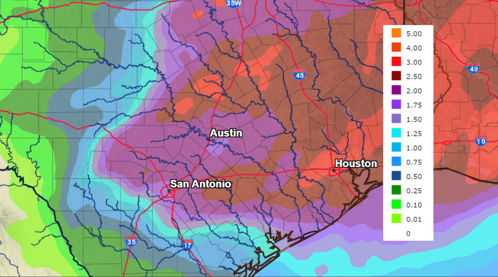
Moderate to heavy rain is forecast with the large complex of thunderstorms Tuesday night. The rain is predicted to persist overnight, tapering off from northwest to southeast late Tuesday night through Wednesday morning. Significant totals or rain are forecast. National Weather Service rainfall forecasts call for widespread totals of 1-3 inches across most of the Hill Country, Central Texas and coastal regions. Isolated totals of 3-5 inches will be possible.
NWS Rainfall Forecast for the Period 7 am Tuesday through 7 am Thursday:
The rain and thunderstorms are forecast to exit Central Texas Wednesday morning and the coastal plains region Wednesday afternoon. The sky is forecast to become mostly sunny Wednesday afternoon. A cold front is expected to follow the complex of storms Wednesday morning, bringing cooler air. High temperatures Wednesday are predicted to be around 78-80 degrees. Lows Thursday morning will include the mid-50s Hill Country, upper 50s Central Texas and the low 60s towards the coast.
Sunny, dry and warmer weather looks to follow Thursday through Memorial Day.
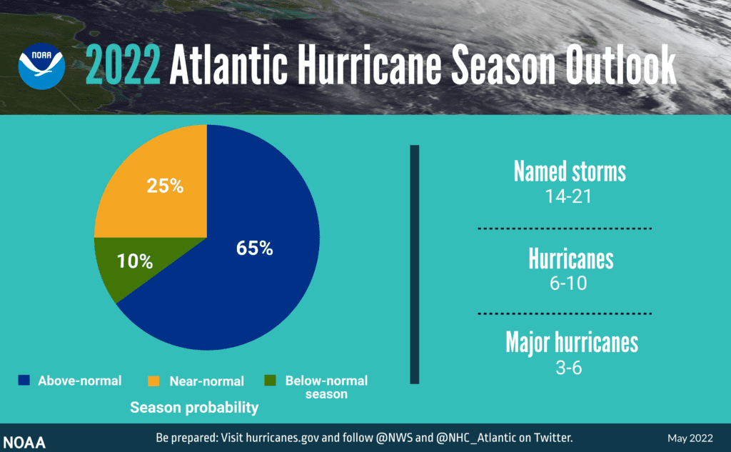
The National Hurricane Center Releases its Prediction for the 2022 Atlantic Hurricane Season
Forecasters at NOAA’s Climate Prediction Center, a division of the National Weather Service, are predicting above-average hurricane activity this year — which would make it the seventh consecutive above-average hurricane season. NOAA’s outlook for the 2022 Atlantic hurricane season, which extends from June 1 to November 30, predicts a 65% chance of an above-normal season, a 25% chance of a near-normal season and a 10% chance of a below-normal season.
For the 2022 hurricane season, NOAA is forecasting a likely range of 14 to 21 named storms (winds of 39 mph or higher), of which 6 to 10 could become hurricanes (winds of 74 mph or higher), including 3 to 6 major hurricanes (category 3, 4 or 5; with winds of 111 mph or higher). NOAA provides these ranges with a 70% confidence.
The increased activity anticipated this hurricane season is attributed to several climate factors, including the ongoing La Niña that is likely to persist throughout the hurricane season, warmer-than-average sea surface temperatures in the Atlantic Ocean and Caribbean Sea, weaker tropical Atlantic trade winds, and an enhanced west African monsoon.
Bob
Social Media