Monday started off rather chilly, with freezing temperatures reported across the Hill Country and locations south to Interstate 10. According to LCRA’s Hydromet, the temperature fell to the mid-20s to mid-30s across much of the region, with upper 30s across the coastal plains. LCRA’s lowest gauged temperature was 20 degrees, at a location a few miles northeast of Coleman, in Coleman County. In Austin, Camp Mabry recorded a low temperature of 33 degrees, while Austin-Bergstrom airport recorded 25 degrees.
As we start off the new week, all eyes are on a large trough of low pressure in the middle and upper atmosphere located over southern Arizona. The trough is forecast to sink southeast into northern Mexico tonight, track northeast across West and Northwest Texas Tuesday, and into the Middle Mississippi Valley Wednesday. Because of this more southern trajectory of the trough, it is expected to be a big weather-maker across Texas Monday night through Tuesday afternoon.
In advance of the approaching trough, clouds are quickly spreading north from the western Gulf of Mexico across South and Central Texas. Expect the sky to become mostly cloudy by late Monday afternoon. Easterly winds look to increase to 10-15 mph. Despite the clouds, Monday’s temperature is forecast to top out around 58-60 degrees.
Widespread light to moderate rain showers are forecast to develop across the region after midnight Monday night as moisture levels rapidly increase.
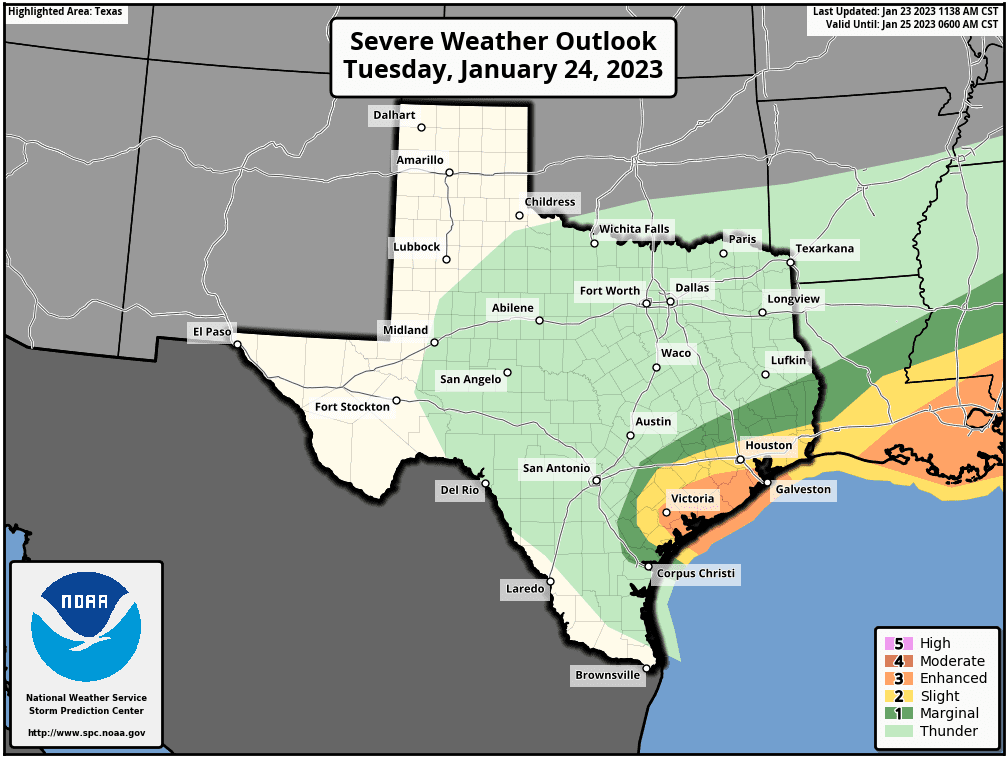
Rain showers and scattered thunderstorms are forecast region-wide Tuesday morning through Tuesday afternoon as the atmospheric lift increases ahead of the trough. At the same time, a warm front along the coast is predicted to lift north to the Interstate 10 corridor, bringing warm and unstable air. Within this zone which looks to extend into the southern counties of Central Texas, there will be a chance for strong to severe thunderstorms Tuesday morning through Tuesday afternoon. The Storm Prediction Center has placed Wharton and Matagorda Counties under an Enhanced Risk (a 3 out of 5 risk) for severe thunderstorms. Colorado County has been placed under s Slight Risk (a 2 out of 5 risk) for severe storms. Fayette County has been placed under a Marginal Risk (a 1 out of 5 risk) for severe thunderstorms. Across the Hill Country and most of Central Texas, the risk for severe storms is expected to be quite low. Severe weather threats will include large hail, damaging straight-line winds, and isolated tornadoes.
Storm Prediction Center Severe Weather Outlook 6 am Tuesday through 6 am Wednesday:
In addition to the threat for severe storms, the other big news will be the widespread soaking rain. The southerly path of the upper trough combined with considerable moisture spreading north from the Gulf is predicted to cause a widespread soaking rain. In fact, some locally heavy rain will be possible for areas along and east of Interstate 35. The rain is forecast to taper off from west to east late Tuesday afternoon as a Canadian cold front brings in drier and more stable air.
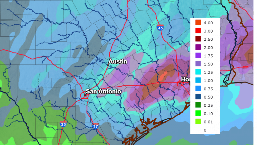
Rain amounts between Monday night and Tuesday evening are forecast to generally average between 0.5 and 1.5 inches across the Hill Country, between 1 and 2 inches across Central Texas, and between 2 and 3 inches across the coastal plains. Some isolated totals of 3-4 inches will be possible—mainly for areas along and east of Interstate 35.
NWS Rainfall Forecast for the Period 6 pm Monday through 6 pm Wednesday:
Breezy and cooler weather will following the cold front Tuesday evening and Tuesday night. Expect northwesterly winds at 10-20 mph, with gusts to near 35 mph.
Mostly sunny, dry, and cool weather is forecast Wednesday through Friday. Do note freezing temperatures will be possible across the Hill Country and Central Texas regions Wednesday, Thursday, and Friday mornings.
- High temperatures Tuesday will include the low and mid-50s across the Hill Country and Central Texas, with upper 60s across the coastal plains.
- Lows Wednesday morning are predicted to be around 30-32 degrees across the Hill Country, in the low and mid-30s across Central Texas, and the upper 30s across the coastal plains
- High temperatures Wednesday will range from the low 50s west, to the upper 50s near the coast.
- Lows Thursday and Friday mornings will include the mid and upper 20s Hill Country, the low 30s across Central Texas, and the mid-30s across the coastal plains.
- Highs Thursday and Friday are forecast to be in the upper 50s.
- Lows Saturday morning are forecast to be in the low and mid-40s.
This coming weekend, there will be a chance for scattered light rain showers to develop Saturday through midday Sunday as a weak trough of low pressure tracks east out of the southern Rockies. Clouds and moisture will return ahead of the trough Friday night. The probability for rain is forecast to be near 30 percent Saturday, 40 percent Saturday night, and 20 percent Sunday morning. Rain amounts are expected to be low—near or less than a quarter inch across the Hill Country and Central Texas regions, and between 0.25 and 0.5 inches across the coastal plains. High temperatures both days are predicted to be in the mid and upper 60s. Lows Sunday morning will be in the 50s.
A Canadian cold front is forecast to push through our area Sunday night in the wake of the upper trough. Breezy and cooler weather will follow Sunday night into Monday. Lows Monday morning are forecast to be in the mid and upper 30s. High temperatures next Monday are forecast to be around 50-52 degrees.
Forecasts call for an increasing chance for rain showers across the region next Monday afternoon through Tuesday as another trough of low pressure swings southeast out of the southern Rockies. An early look at rainfall shows amounts averaging around a half inch.
Mostly sunny, dry and cooler weather looks to follow this system next Wednesday through Friday. Expect high temperatures in the 50s to around 60s, with lows in the 30s and low 40s.
Comet ZTF Update
Multiple observers are reporting a surge in the brightness of Comet ZTF. In fact, over the past few days, the comet has crossed the threshold of naked-eye visibility. The comet is approaching Earth for a close encounter (0.28 AU) on Feb. 1st. Forecasters expected it to reach magnitude +5.5 to +5.0. It appears to have hit that mark more than a week early. The sudden brightening makes Comet ZTF a barely naked-eye object in dark-sky locations, and an easy target for backyard telescopes.
Comet ZT is currently in northern skies in the early morning hours. But it’s heading toward the north celestial pole and Polaris, which means you’ll be able to spot it in the evening hours soon. It will be in the general vicinity of Polaris – the North Star – beginning January 30.
I’ll pass along more details later this week.
Bob
Social Media