Partly cloudy and quiet weather will be in place this afternoon through Saturday afternoon. Temperatures this afternoon will warm to the low and mid-50s. Lows Saturday morning will include the upper 20s across the Hill Country, the low 30s across Central Texas and the upper 30s towards the coast. High temperatures Saturday will be in the low and mid-50s.
Big changes in the weather are forecast to take place across our region beginning Saturday night. At that time, a strong trough of low pressure in the upper atmosphere sinking south out of the southern Rockies is forecast to reach a position near the Four Corners. The trough is predicted to dive southeast across New Mexico Sunday morning, turning east-northeast across Northwest Texas Sunday afternoon into Sunday night. With the trough taking this southerly route into Texas, the system is expected to have a big impact on our region’s weather.
Widespread light rain showers are forecast to develop across the region after midnight Saturday night when Gulf moisture is pulled north up and over the cold air mass in place. A steady, widespread light to moderate rain is forecast to continue throughout the day Sunday and into Sunday evening. The precipitation is predicted to end from west to east Sunday night as trough exits off to the northeast.
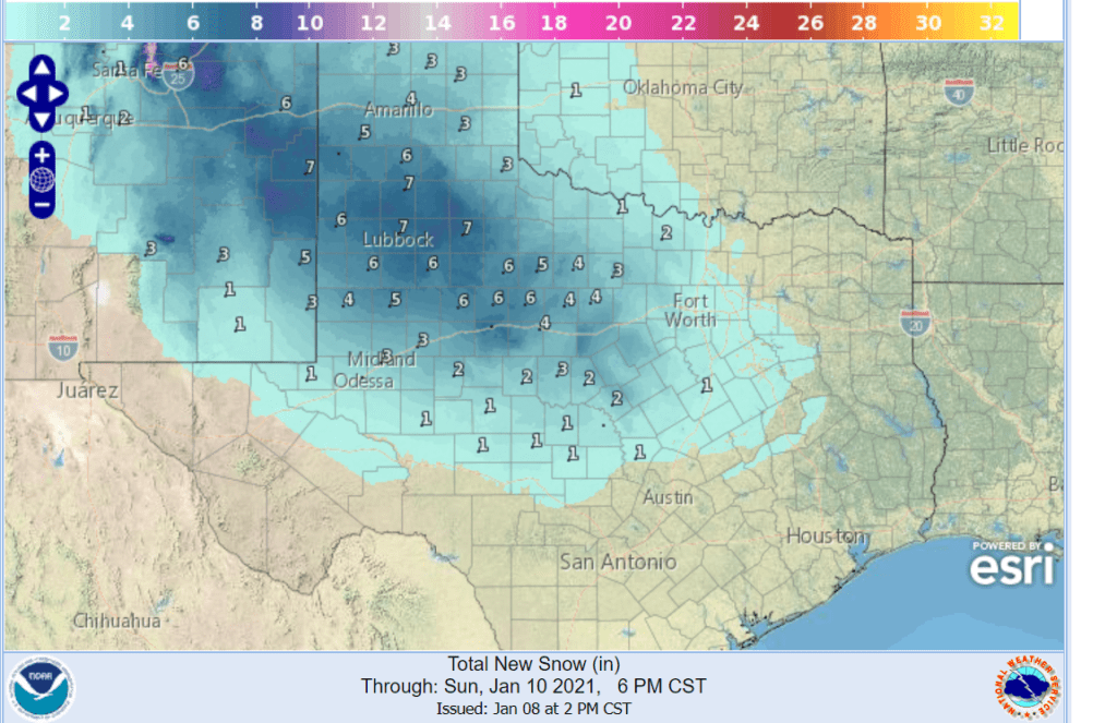
Confidence is increasing the incoming trough of low pressure will cause the development of accumulating snow across western Texas, much of the Texas Hill Country and even across parts of Central Texas. While all of the precipitation is forecast to start off as a cold rain, temperatures in the lower and middle atmosphere are predicted to fall below freezing with the approach of the upper trough, causing the rain to transition over to snow. There remains considerable uncertainty, however, as to just how far south the potential for snow will exist. Friday’s morning’s data suggests snow will be possible for areas generally north of a line stretching from Sonora to San Marcos to Hempstead. This snow potential area includes the Austin metropolitan area.
- For the Hill Country region, a mix of rain and snow is forecast to develop across the Hill Country region early Sunday afternoon, with the precipitation becoming mostly all snow late Sunday afternoon into Sunday evening. The precipitation should taper off late Sunday evening. Total snow amounts are forecast to range from around 4-6 inches in the Abilene/Brownwood area to around 2 inches in the Burnet/Llano/Junction area.
- For the Central Texas region, a cold rain is forecast Sunday morning into Sunday afternoon. A mix of rain and snow is forecast to develop mid to late Sunday afternoon, with the precipitation continuing through late evening. Total snow accumulations are forecast to be around 1 inch. The precipitation should taper off by midnight Sunday night.
- For the southern counties of Central Texas and the coastal plains region, a cold rain is forecast Sunday into Sunday night. The rain should taper off after midnight Sunday night.
Pasted below is the National Weather Service’s snowfall forecast through Monday morning. Do note the NWS forecast is not calling for the snow to develop as far south as I am predicting.
Temperatures will be cold Sunday, but are predicted to be above freezing. High temperatures will range from around 40 degrees across the northern Hill Country to the low and mid-40s across Central Texas to the upper 40s towards the coast.
Colder temperatures are forecast Sunday night as the precipitation ends and the sky clears. Lows Monday morning will include the mid-20s across the Hill Country, the upper 20s across Central Texas and the low to mid-30s near the coast.
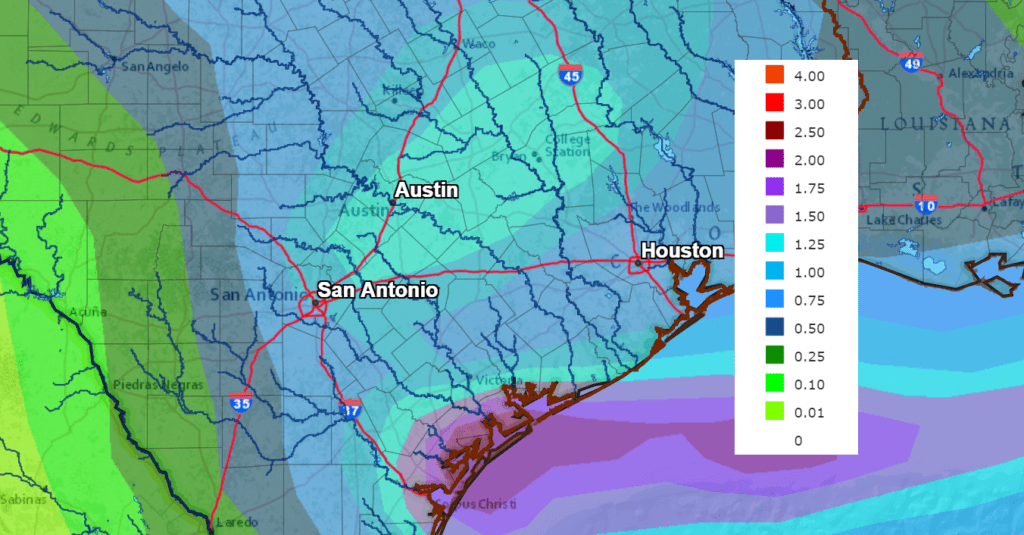
This weekend’s storm system is forecast to bring widespread precipitation to all of the region. Rainfall forecasts call for totals to average around 1 inch across the eastern Hill Country, Central Texas and the middle Texas coast. Some slightly higher totals will be possible across parts of Central Texas.
NWS Rainfall Forecast for the Period 6 pm Friday through 6 pm Monday:
The outlook for next week calls for sunny and dry weather Tuesday through Friday. High temperatures in the mid-50s Monday, will warm to the mid-60s on Thursday and Friday. Lows will be in the upper 20s to mid-30s Tuesday morning and in the 30s for the remainder of the week.
Bob
Social Media