A widespread area of rain and thunderstorms developed Thursday afternoon and evening across West Texas, the Edwards Plateau and the Rio Grande plains. The area of rain moved slowly southeast across the Hill Country, Central Texas, and coastal regions Thursday night into Friday morning. Overnight and morning totals generally ranged between 1 and 3 inches across the Hill Country, with an area of 3-6 inch totals occurring across parts of McCulloch, San Saba and Mason Counties. Across Central Texas and the middle Texas coast, most totals ranged between 0.25 and 1.5 inches.
As of midday Friday, the rain had ended across the Hill Country, Central Texas and the majority of the middle Texas coast.
A break from the widespread rain and thunderstorms is forecast to take place across the region this afternoon and evening as the atmosphere stabilizes a bit in the wake of this morning’s rain. There will still be a 30 percent chance for scattered showers and thunderstorms this afternoon and evening, but widespread or heavy rain is not expected. Expect a partly to mostly cloudy sky and a high temperature in the low to mid-80s.
Friday’s weather maps showed a large area low pressure in the middle atmosphere located over the Four Corners region. The low is forecast to track east across New Mexico this afternoon, then lift northeast across Oklahoma and into Kansas on Saturday. A weak cold front associated with the upper trough was stationary, and stretched from the DFW area, to just north of Austin, and west to Del Rio. The boundary is forecast to remain in essentially the same location through Saturday and this will help to enhance the chance for rain.
High-resolution forecasts call for an area of thunderstorms to develop across the lower Trans Pecos region of West Texas this evening as another wave of low pressure rotates around the large low over New Mexico. This activity is predicted to track east-southeast and should enter the Edwards Plateau and western Hill Country regions around midnight. The area of rain and storms is forecast to spread east across the Hill Country and to the Interstate 35 corridor region after midnight.
Saturday’s weather is shaping up to be cloudy and wet across entire region. The area of rain and thunderstorms moving out of West Texas is predicted to linger over much of the region , being enhanced by the stalled cold front and additional disturbances moving out of West Texas. A widespread light to moderate rain with embedded thunderstorms is forecast to be in place for much of the day. Expect a high temperature in the low 80s.
The rain is forecast to slowly taper off from northwest to southeast Saturday evening into Saturday night as the upper trough pulls further north, ending the parade of weak disturbances moving out of West Texas.
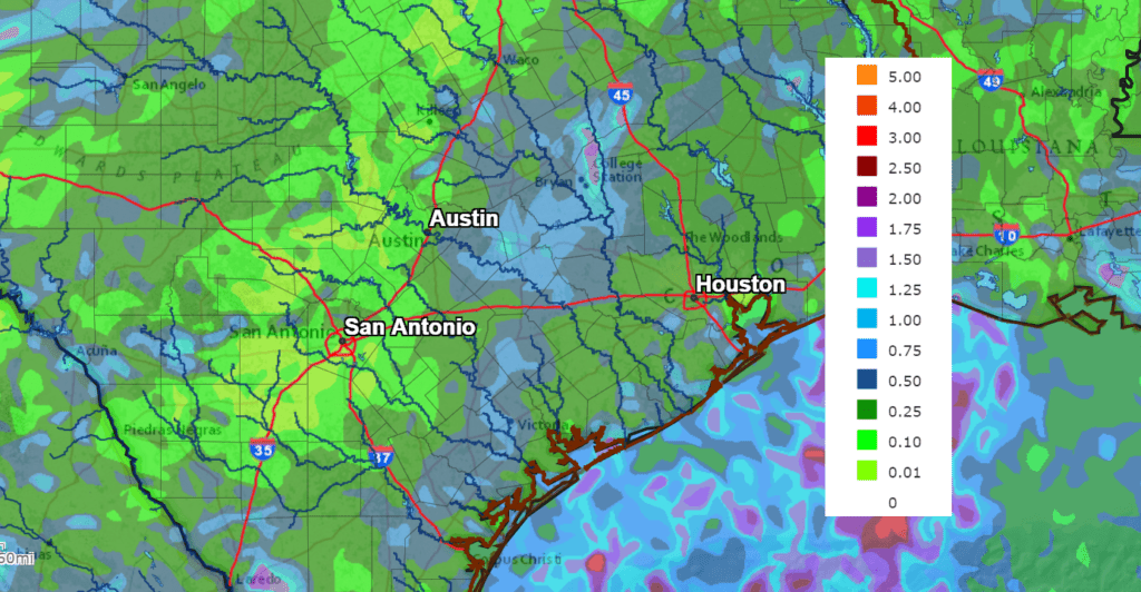
Rain amounts between Friday afternoon and early Sunday morning are forecast to generally average between 0.15 and 1 inch. A few isolated heavier totals will be possible.
NWS Rainfall Forecast for the Period 7 pm Friday through 7 pm Monday
On Sunday, the cold front is forecast to shift southeast to the coastal plains and pull up stationary. There will be a 20 percent chance for spotty rain showers across the Hill Country and the Interstate 35 corridor. Southeast of Austin between La Grange and Bay City, expect a 40-50 percent chance for showers and thunderstorms—especially Sunday afternoon. Additional totals of 0.25-0.5 inches will be possible. Expect a partly to mostly cloudy sky with temperatures warming to the upper 80s.
Sunny and dry weather is forecast Monday as the cold front finally pushes east into the Gulf of Mexico and a bubble of Canadian high pressure slides south into Texas. This sunny and dry pattern is predicted to hold through all of next week and next weekend as the storm track shifts up to the north and east. High temperatures throughout the week are forecast to be in the mid and upper 80s. Low temperatures will include the mid-50s across the Hill Country, the upper 50s to low 60s across Central Texas and the low 60s across the coastal plains.
High temperatures are predicted to warm into the low 90s next weekend.
Tropical Weather Update
Weather conditions remain quiet across the Gulf of Mexico and the Caribbean Sea. There are no systems in place which pose a threat for tropical development through late next week.
Across the tropical Atlantic, forecasters continue to monitor the progress of Hurricane Sam and Tropical Storm Victor.
Hurricane Sam remains a powerful category 4 hurricane over the central Atlantic. As of 10 am, the center of Hurricane Sam was located about 325 miles southeast of Bermuda. Sam was moving toward the north near 21 mph. A turn toward the north-northeast, at a slightly slower forward speed, is expected by tonight, followed by a northeastward motion Saturday night through Monday. On the forecast track, the center of Sam will pass well to the east of Bermuda Friday night. Maximum sustained winds remain near 150 mph, with higher gusts. Sam is a category 4 hurricane on the Saffir-Simpson Hurricane Wind Scale. Although fluctuations in intensity are still possible today, weakening is forecast during the next couple of days. However, Sam is expected to remain a major hurricane through at least Saturday night.
As of 10 am CDT, the center of Tropical Storm Victor was located over the eastern Atlantic, about 710 miles west-southwest of the Cabo Verde Islands. Victor was moving toward the west-northwest near 15 mph. The tropical storm is forecast to continue moving west-northwestward at a slightly slower forward speed today. A turn toward the northwest is anticipated over the weekend, and that motion will likely continue into early next week. Maximum sustained winds have increased to near 65 mph with higher gusts. Little change in strength is expected today. Over the weekend, Victor is forecast to slowly weaken.
The remainder of the tropical Atlantic is quiet, with no systems showing any signs of development.
Have a good weekend.
Bob
Social Media