Quiet and very fall-like weather is in place as we start off the new week. Sunday’s cold front brought in another push of cool, dry air to Central and South Texas. Monday’s temperature started off a little chilly, with 30s and 40s across the Hill Country and low to mid-50s across the rest of the region. According to LCRA’s Hydromet, 3 gauges near and west of Lake Brownwood recorded minimum temperatures at or just below freezing.
Monday’s weather maps showed a large dome of Canadian high pressure stretching from the northern Plains states to southern Texas. Cool air is spreading south into Texas with the high pressure system. This afternoon’s weather will feature a mostly sunny sky, light winds and fall-like temperatures. Highs will be in the mid-60s across the Hill Country and near 68-70 degrees at most other locations.
Expect chilly readings Monday night, but no freezing temperatures are expected as a considerable high-level clouds spread over the area. Lows will include the mid and upper 30s across the Hill Country, the low 40s across Central Texas and the low to mid-40s across the coastal plains.
Tuesday’s weather will be mostly sunny and a little warmer as the dome of high pressure shifts east, bringing a return of southerly breezes. Expect winds to pick up to 10-15 mph in the afternoon. The high temperature will generally be near 70-72 degrees. Lows clouds will increase and the sky should become cloudy Tuesday night. Lows Wednesday morning will be in the low and mid-50s.
Changes in the weather will begin to take place Wednesday when a large trough of low pressure drops southeast out of the northern Rockies. A piece of the trough is forecast to break off and sink southwest to a position over northern Baja, California through late week. More on this feature coming up. The main trough is forecast to track east-southeast across the Plains states Wednesday into Thursday, forcing a Canadian cold front south into Texas. The front is forecast to reach Northwest Texas late Wednesday evening, tracking southeast into the northern Hill Country late Wednesday night. The front is predicted to push through the Austin area near or just after sunrise Thursday, reaching the coastal plains region in the early afternoon. Conditions appear favorable for a widespread area of rain showers and scattered thunderstorms to develop along and just behind the front. The threat for severe storms appears to be quite low.
In advance of the cold front, Wednesday’s weather is shaping up to be mostly cloudy, breezy and warm as moisture streams north from the Gulf. Expect a southerly breezy at 10-20 mph, with gusts to 30 mph. High temperatures will be in the mid and upper 70s. Cloudy and breezy conditions look to continue Wednesday night. Occasional light showers are forecast to develop across Central Texas and the coastal region as the atmosphere becomes increasingly moist and unstable.
Attention will turn to the northern Hill Country Wednesday night when a large area of rain and thunderstorms spreads southeast with the cold front. The rain and storms are predicted to spread southeast across the Hill Country Wednesday night, reaching the Austin and Interstate 35 corridor around daybreak Thursday. The rain and storms are forecast to continue spreading southeast across Central Texas Thursday morning and the coastal region Thursday afternoon. Meanwhile, the rain is expected to taper off across the Hill Country and the Intestate 35 corridor Thursday morning, Central Texas Thursday afternoon and the coastal region Thursday evening.
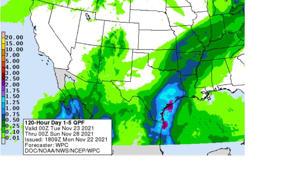
Rain amounts Wednesday night through Thursday are expected to be heaviest for areas east of Interstate 35, where totals of 1-1.5 inches are forecast. To the west of I-35, totals of 0.25-0.5 inches are forecast.
NWS Rainfall Forecast for the Period 6 pm Monday through 6 pm Saturday:
Thanksgiving Day temperatures will be noticeably cooler, with highs only in the low 60s across the Hill Country and most of Central Texas. Across the coastal plains, temperatures should reach the low 70s ahead of the front.
Lows Friday morning are predicted to be in the mid-30s across the Hill Country, be around 38-40 degrees across Central Texas and in the mid to upper 40s across the coastal plains.
Sunny and cool weather is forecast across the region Friday through Sunday. High temperatures will be around 58-62 degrees Friday, warming to the mid-60s Saturday, and the upper 60s on Sunday. Lows Saturday and Sunday mornings will be in the low and mid-40s, with upper 40s to 50 degrees near the coast.
Looking ahead to next week, a partly cloudy sky and mild temperatures is predicted for Monday and Tuesday. Expect a high temperature near 70 degrees, with a low temperature in the 50s. Forecasts call for a chance for rain to develop next Wednesday and Thursday when the stalled area of low pressure over northern Baja finally lifts northeast and moves across Texas. As of now, it appears rain amounts should average between a quarter and a half inch. No significant change in the temperature is forecast. Highs should continue around 70 degrees, with lows in the 50s.
There are no signs of any unusually cold air sinking south into Texas through the first week of December.
Tropical Weather Outlook
There will be no tropical concerns in the Pacific or Atlantic Oceans over the next 5-10 days.
I hope everyone has a safe and enjoyable Thanksgiving holiday!
Bob
Social Media