A cold front quietly tracked south across our region Thursday night, bringing with it more cool and dry air. A ridge of high pressure located to our west is going to keep weather conditions sunny and dry this afternoon, Saturday and Sunday. This latest batch of cool air is expected to hang around into Saturday, before milder readings develop Saturday afternoon through Sunday. But do note a freeze is forecast across the Hill Country both Friday night and Saturday night and across the Central Texas and the coastal regions Friday night. Northwesterly winds at 10-20 mph will be in place this afternoon. Wind speeds should become light Friday night and remain between 5 and 10 mph through the weekend. Overall, this weekend`s weather is shaping up to be about as close to picture perfect as you can get in late January.
- High temperatures Friday afternoon are forecast to be in the mid and upper 50s.
- Lows Saturday morning are predicted to be in the mid and upper 20s across the Hill Country, and in the lower 30s at most other locations.
- High temperatures Sunday are forecast to be in the mid-60s.
- Lows Sunday morning will include the low 30s across the Hill Country, and be in the mid to upper 30s elsewhere.
- High temperatures Sunday are predicted to be around 68-70 degrees.
- Lows Monday morning will range from the mid-40s across the Hill Country, to the low 50s near the coast.
A significant change in the weather is forecast to take place Sunday night into Monday when a good chance for widespread rain and thunderstorms is expected to take place. For a large part of the Hill Country, this is looking like the first widespread rain event to take place in more than 2 months. A potent trough of low pressure in the upper atmosphere currently located about 500 miles west of California, is forecast to track east over the weekend and move across Texas on Monday. The trough is expected to have an impressive amount of atmospheric lift, but limited moisture to work—especially for the area west of Interstate 35. Light rain showers and isolated thunderstorms are predicted to develop across the region after midnight Sunday night. This will be followed by widespread rain showers and isolated thunderstorms Monday. The rain is forecast to taper off across the Hill Country by about noon, with the sky then becoming mostly sunny in the afternoon. The rain is forecast taper off across Central Texas by early Monday afternoon and across the coastal region in the late afternoon. The threat for any strong to severe thunderstorms with this system will be very low.
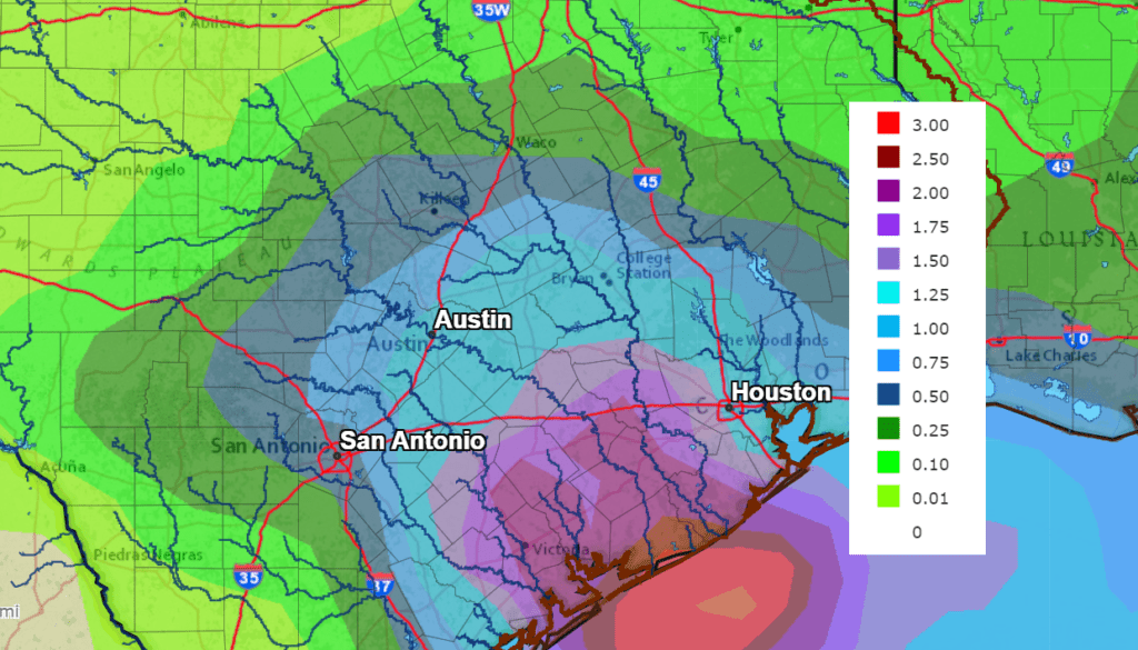
Rain amounts from the trough are forecast to be the lowest across the Hill Country, where totals should average between 0.25 and 0.5 inches. Across Central Texas, totals are forecast to average between 0.5 and 1 inch, while totals of 1-2 inches are predicted for the middle Texas coast.
NWS Rainfall Forecast for the Period 6 pm Friday through 6 pm Wednesday:
- Sunny, dry, and mild weather is forecast Tuesday into Wednesday morning in the wake of Monday’s trough of low pressure.
- Lows Tuesday morning will range from the upper 30s to low 40s west, to the low 50s near the coast.
- High temperatures Tuesday are forecast to be near 70 degrees.
- Lows Wednesday morning will range from the mid-40s Hill Country, to the mid-50s near the coast.
- High temperatures Wednesday are forecast to be around 68-72 degrees.
A change back to a much colder pattern is forecast late next week when an arctic cold front presses south into Texas. Forecasts call for a large trough of low pressure to develop south out of western Canada the middle of next week. This will allow an area of arctic air to spread south down the Plains states. The arctic front, or leading edge of the arctic air, is forecast to sweep across Central and South Texas Wednesday afternoon and Wednesday evening. Conditions appear favorable for a 40-50 percent chance for light rain showers to develop along and behind the cold front through Wednesday night. Rain amounts are predicted to average less than a quarter inch.
I will point out some of the forecast solutions are indicating a potential for some snow to develop across the Hill Country and the northern half of Central Texas Wednesday night into early Thursday morning as the arctic air quickly settles over the area. My confidence in this wintery weather developing is currently low. But it is a slight possibility. Forecasters should have a better handle on this potential threat for wintery weather early next week.
In the wake of Wednesday’s cold front, sunny, dry and very cold weather is forecast next Thursday, continuing into next weekend. Here’s rough estimate of the kind of temperatures I expect:
- Lows Thursday morning are forecast to be close to 30 degrees.
- Lows Friday and Saturday mornings are forecast to be in the mid and upper 20s.
- Lows next Saturday morning are forecast to be in the low 30s.
- High temperatures Thursday through Saturday are forecast to be around 45-50 degrees.
Long-range forecasts call for milder temperatures to develop next Sunday and continue into the first half of the following week.
Just One Planet is Visible Now in the Evening Sky
The winter stars are ablaze in the night sky right now, but only one planet, Jupiter, is visible. Look for bright Jupiter in the southwestern sky shortly after sunset through early next week. Jupiter is sinking lower each day and by February 2nd, it will be lost in the sun’s glare. All of the planetary action has shifted to the sky just before sunrise, where Venus and Mars are visible. Jupiter will be joining the morning “crew” of planets in March.
Have a good weekend.
Bob
Social Media